last update to page: December 18 2016 01:10:22 (UTC).
Magnitude 7.9 Earthquake: New Ireland Region, P.n.g.
SummaryThe red marker denotes the earthquake epicenter. On Sat Dec 17th 2016 10:51:12 (UTC) the seismic network recorded an earthquake (preliminary 7.9 mww) located in New Ireland Region, P.n.g.. Seismic region Bismarck And Solomon Islands. The epicentral distance (i.e. distance separating the location to the epicenter) to the closest station S12K in the network is 7,834.7 km. If you felt the quake, the USGS would like to know. Please add your comments to the USGS page "Did you feel it?". |
Details
Proximity to Population Centers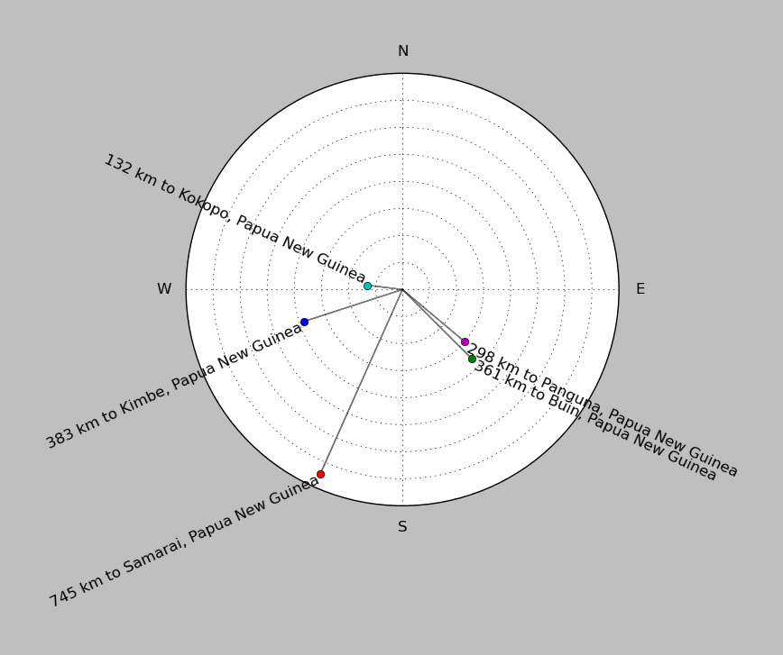
| ||||||||||||||||
Event and active stations
|
|||||||||||||||||
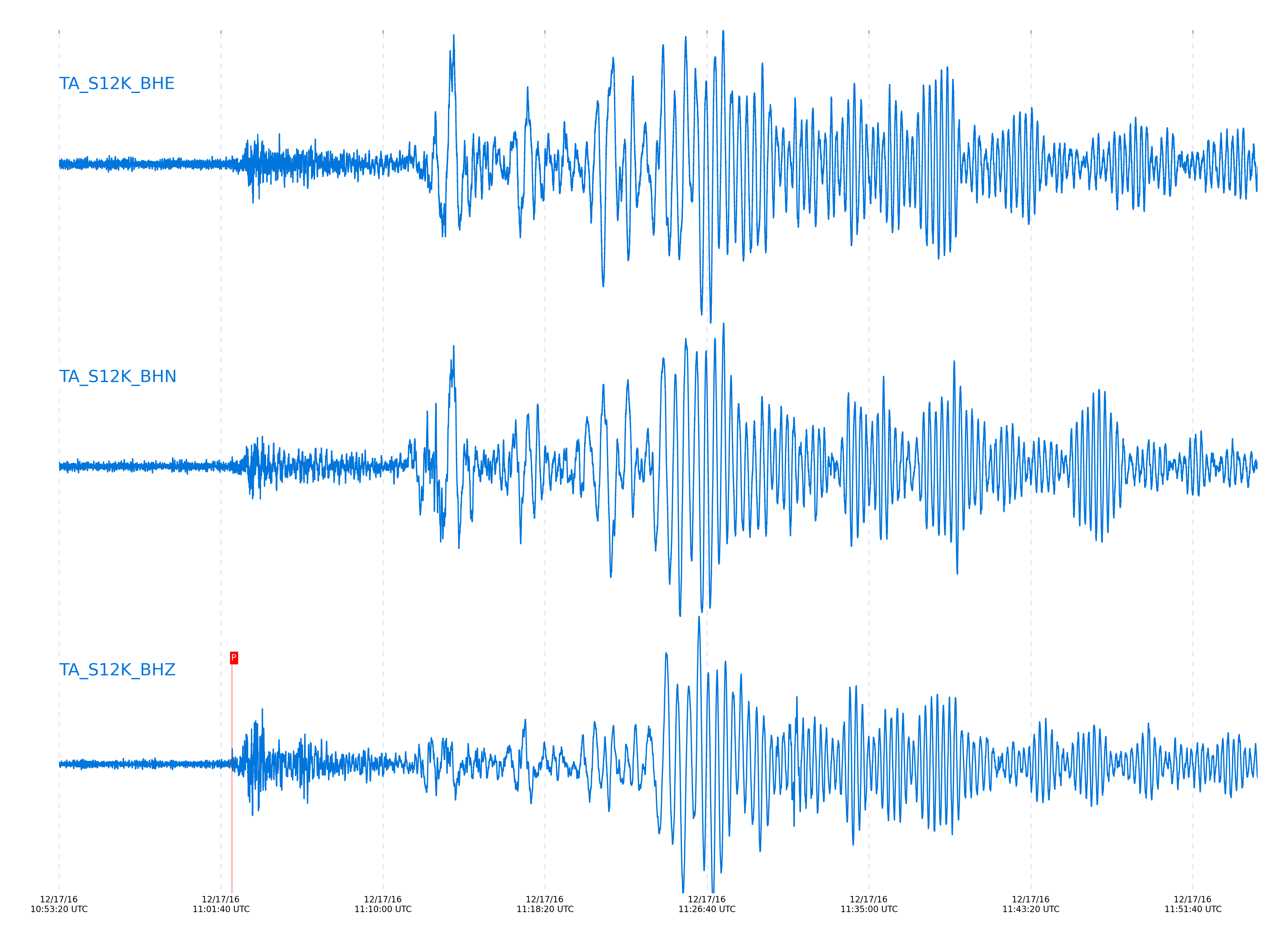
Seismic waveforms for closest station
Closest station with identified signal. Not filtered.
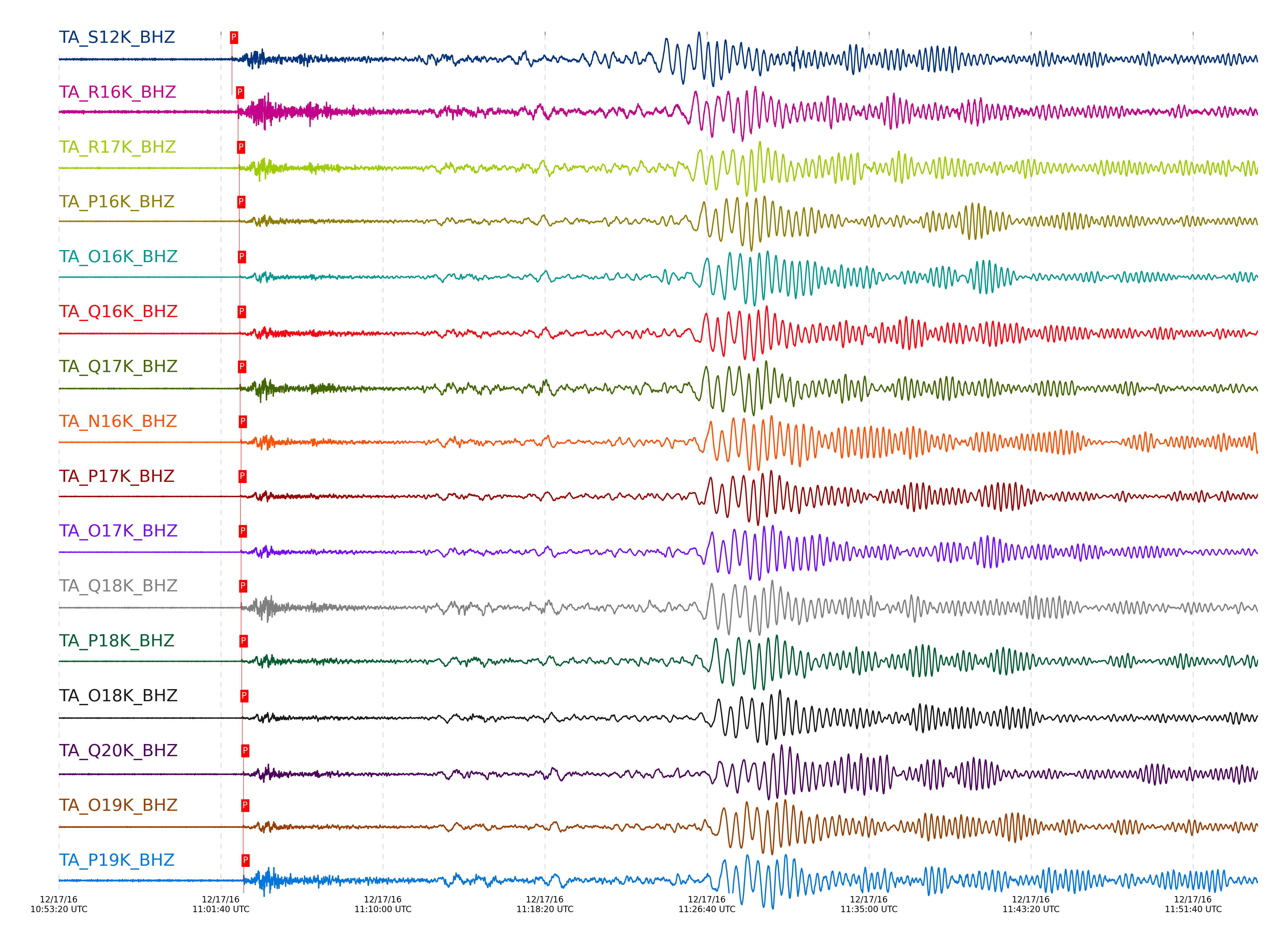
Seismic waveforms for vertical channels in network
Subset of several stations close to the event. Not filtered.
Signal description at some stations
| STA_CHAN | S-E Delta | S-E Azimuth | Phase | Time | Signal/Noise | Time Residual | V. Model | Auth | arid |
|---|---|---|---|---|---|---|---|---|---|
| S12K_BHZ | 70.38° | 227.87° | P | 2016-12-17 11:02:14.2104 UTC | 8.4669 | -1.117 | iasp91 | dbp:jtytell:163 | 3440208 |
| R16K_BHZ | 73.467° | 231.68° | P | 2016-12-17 11:02:32.9495 UTC | 9.7928 | -0.832 | iasp91 | dbp:jtytell:163 | 3440213 |
| R17K_BHZ | 74.014° | 232.78° | P | 2016-12-17 11:02:36.2125 UTC | 50.893 | -0.766 | iasp91 | dbp:jtytell:163 | 3440214 |
| P16K_BHZ | 74.211° | 230.95° | P | 2016-12-17 11:02:36.9877 UTC | 17.252 | -1.139 | iasp91 | dbp:jtytell:163 | 3439958 |
| O16K_BHZ | 74.526° | 230.73° | P | 2016-12-17 11:02:38.68 UTC | -1 | -1.27 | iasp91 | dbp:jtytell:163 | 3441078 |
| Q16K_BHZ | 74.533° | 232.29° | P | 2016-12-17 11:02:38.2824 UTC | 12.214 | -1.708 | iasp91 | dbp:jtytell:163 | 3439933 |
| Q17K_BHZ | 74.602° | 233.11° | P | 2016-12-17 11:02:39.2524 UTC | 109.78 | -1.139 | iasp91 | dbp:jtytell:163 | 3439932 |
| N16K_BHZ | 74.828° | 229.9° | P | 2016-12-17 11:02:41.7626 UTC | -1 | 0.066 | iasp91 | dbp:jtytell:163 | 3441079 |
| P17K_BHZ | 74.937° | 232.39° | P | 2016-12-17 11:02:40.4429 UTC | 16.475 | -1.884 | iasp91 | dbp:jtytell:163 | 3439959 |
| O17K_BHZ | 75.031° | 231.64° | P | 2016-12-17 11:02:41.9668 UTC | 37.801 | -0.898 | iasp91 | dbp:jtytell:163 | 3440226 |
| Q18K_BHZ | 75.2° | 233.85° | P | 2016-12-17 11:02:42.6087 UTC | 92.293 | -1.226 | iasp91 | dbp:jtytell:163 | 3439934 |
| P18K_BHZ | 75.549° | 233.48° | P | 2016-12-17 11:02:44.038 UTC | 29.009 | -1.796 | iasp91 | dbp:jtytell:163 | 3439960 |
| O18K_BHZ | 75.833° | 233.41° | P | 2016-12-17 11:02:46.1376 UTC | -1 | -1.314 | iasp91 | dbp:jtytell:163 | 3441083 |
| Q20K_BHZ | 76.293° | 236.28° | P | 2016-12-17 11:02:49.3412 UTC | 15.161 | -0.723 | iasp91 | dbp:jtytell:163 | 3440217 |
| O19K_BHZ | 76.392° | 234.17° | P | 2016-12-17 11:02:49.177 UTC | 32.944 | -1.446 | iasp91 | dbp:jtytell:163 | 3439961 |
| P19K_BHZ | 76.524° | 235.3° | P | 2016-12-17 11:02:50.3814 UTC | -1 | -0.985 | iasp91 | dbp:jtytell:163 | 3441084 |
| N19K_BHZ | 76.69° | 233.9° | P | 2016-12-17 11:02:51.6875 UTC | -1 | -0.613 | iasp91 | dbp:jtytell:163 | 3441085 |
| O20K_BHZ | 77.019° | 235.78° | P | 2016-12-17 11:02:52.9407 UTC | 17.203 | -1.205 | iasp91 | dbp:jtytell:163 | 3439962 |
| L19K_BHZ | 77.36° | 233.3° | P | 2016-12-17 11:02:56.118 UTC | 192.14 | 0.066 | iasp91 | dbp:jtytell:163 | 3439935 |
| M19K_BHZ | 77.369° | 233.78° | P | 2016-12-17 11:02:56.2577 UTC | -1 | 0.154 | iasp91 | dbp:jtytell:163 | 3441086 |
| N20K_BHZ | 77.815° | 235.96° | P | 2016-12-17 11:02:56.894 UTC | 25.203 | -1.687 | iasp91 | dbp:jtytell:163 | 3439963 |
| M20K_BHZ | 77.839° | 234.98° | P | 2016-12-17 11:02:58.4533 UTC | -1 | -0.263 | iasp91 | dbp:jtytell:163 | 3441087 |
| L20K_BHZ | 77.9° | 234.17° | P | 2016-12-17 11:02:59.0336 UTC | -1 | -0.022 | iasp91 | dbp:jtytell:163 | 3441088 |
| K20K_BHZ | 78.346° | 233.84° | P | 2016-12-17 11:03:01.649 UTC | -1 | 0.132 | iasp91 | dbp:jtytell:163 | 3441089 |
| O22K_BHZ | 78.443° | 238.4° | P | 2016-12-17 11:03:01.2573 UTC | 27.412 | -0.788 | iasp91 | dbp:jtytell:163 | 3439970 |
| J20K_BHZ | 78.804° | 233.63° | P | 2016-12-17 11:03:04.0711 UTC | 232.51 | 0.044 | iasp91 | dbp:jtytell:163 | 3440153 |
| M22K_BHZ | 78.952° | 237.81° | P | 2016-12-17 11:03:03.2794 UTC | 45.93 | -1.555 | iasp91 | dbp:jtytell:163 | 3439971 |
| P23K_BHZ | 79.19° | 240.61° | P | 2016-12-17 11:03:05.5176 UTC | 6.0402 | -0.613 | iasp91 | dbp:jtytell:163 | 3439966 |
| Q23K_BHZ | 79.385° | 241.67° | P | 2016-12-17 11:03:06.6658 UTC | -1 | -0.525 | iasp91 | dbp:jtytell:163 | 3441090 |
| M23K_BHZ | 79.942° | 240.03° | P | 2016-12-17 11:03:09.2807 UTC | 21.924 | -0.92 | iasp91 | dbp:jtytell:163 | 3439976 |
| H21K_BHZ | 80.132° | 234.68° | P | 2016-12-17 11:03:10.8259 UTC | -1 | -0.394 | iasp91 | dbp:jtytell:163 | 3441091 |
| I21K_BHZ | 80.14° | 235.53° | P | 2016-12-17 11:03:11.0432 UTC | -1 | -0.219 | iasp91 | dbp:jtytell:163 | 3441093 |
| G21K_BHZ | 80.402° | 233.9° | P | 2016-12-17 11:03:12.1866 UTC | -1 | -0.482 | iasp91 | dbp:jtytell:163 | 3441094 |
| M24K_BHZ | 80.732° | 241.41° | P | 2016-12-17 11:03:14.4261 UTC | 49.131 | 0 | iasp91 | dbp:jtytell:163 | 3439980 |
| H22K_BHZ | 80.748° | 236.01° | P | 2016-12-17 11:03:14.1409 UTC | -1 | -0.372 | iasp91 | dbp:jtytell:163 | 3441095 |
| F21K_BHZ | 80.826° | 233.82° | P | 2016-12-17 11:03:14.2048 UTC | -1 | -0.723 | iasp91 | dbp:jtytell:163 | 3441096 |
| I23K_BHZ | 81.043° | 238.02° | P | 2016-12-17 11:03:14.7431 UTC | 90.318 | -1.336 | iasp91 | dbp:jtytell:163 | 3440161 |
| N25K_BHZ | 81.156° | 242.92° | P | 2016-12-17 11:03:16.3464 UTC | 48.924 | -0.328 | iasp91 | dbp:jtytell:163 | 3439981 |
| G22K_BHZ | 81.282° | 235.75° | P | 2016-12-17 11:03:16.7264 UTC | -1 | -0.613 | iasp91 | dbp:jtytell:163 | 3441097 |
| HARP_BHZ | 81.288° | 242.3° | P | 2016-12-17 11:03:16.8671 UTC | 40.711 | -0.504 | iasp91 | dbp:jtytell:163 | 3439943 |
| H23K_BHZ | 81.339° | 237.76° | P | 2016-12-17 11:03:17.029 UTC | -1 | -0.613 | iasp91 | dbp:jtytell:163 | 3441098 |
| F22K_BHZ | 81.401° | 235.04° | P | 2016-12-17 11:03:17.6597 UTC | -1 | -0.306 | iasp91 | dbp:jtytell:163 | 3441099 |
| TCOL_BHZ | 81.442° | 239.46° | P | 2016-12-17 11:03:16.3452 UTC | 179.51 | -1.84 | iasp91 | dbp:jtytell:163 | 3440162 |
| G23K_BHZ | 81.652° | 237.19° | P | 2016-12-17 11:03:19.0492 UTC | -1 | -0.241 | iasp91 | dbp:jtytell:163 | 3441101 |
| K24K_BHZ | 81.701° | 241.54° | P | 2016-12-17 11:03:18.6903 UTC | 35.024 | -0.854 | iasp91 | dbp:jtytell:163 | 3440165 |
| POKR_BHZ | 81.721° | 239.83° | P | 2016-12-17 11:03:17.3313 UTC | 69.902 | -2.322 | iasp91 | dbp:jtytell:163 | 3440163 |
| E22K_BHZ | 81.872° | 235.31° | P | 2016-12-17 11:03:20.1784 UTC | -1 | -0.263 | iasp91 | dbp:jtytell:163 | 3441104 |
| H24K_BHZ | 81.927° | 239.33° | P | 2016-12-17 11:03:18.9548 UTC | -1 | -1.774 | iasp91 | dbp:jtytell:163 | 3441105 |
| M26K_BHZ | 82.183° | 244.28° | P | 2016-12-17 11:03:21.2115 UTC | 57.118 | -0.854 | iasp91 | dbp:jtytell:163 | 3440252 |
| J25K_BHZ | 82.241° | 241.82° | P | 2016-12-17 11:03:21.3176 UTC | -1 | -1.051 | iasp91 | dbp:jtytell:163 | 3441106 |
| L26K_BHZ | 82.311° | 243.89° | P | 2016-12-17 11:03:22.1835 UTC | 128.3 | -0.547 | iasp91 | dbp:jtytell:163 | 3439945 |
| A21K_BHZ | 82.471° | 230.31° | P | 2016-12-17 11:03:22.6665 UTC | 59.455 | -0.898 | iasp91 | dbp:jtytell:163 | 3440236 |
| G24K_BHZ | 82.505° | 239.6° | P | 2016-12-17 11:03:23.2143 UTC | -1 | -0.525 | iasp91 | dbp:jtytell:163 | 3441107 |
| E23K_BHZ | 82.512° | 237.42° | P | 2016-12-17 11:03:23.6012 UTC | -1 | -0.175 | iasp91 | dbp:jtytell:163 | 3441108 |
| M27K_BHZ | 82.634° | 245.31° | P | 2016-12-17 11:03:24.6465 UTC | 181.68 | 0.241 | iasp91 | dbp:jtytell:163 | 3440253 |
| D23K_BHZ | 82.682° | 236.3° | P | 2016-12-17 11:03:24.9385 UTC | -1 | 0.285 | iasp91 | dbp:jtytell:163 | 3441109 |
| O28M_BHZ | 82.728° | 247.02° | P | 2016-12-17 11:03:25.0674 UTC | 84.716 | 0.176 | iasp91 | dbp:jtytell:163 | 3440227 |
| F24K_BHZ | 82.784° | 239.12° | P | 2016-12-17 11:03:25.2503 UTC | -1 | 0.066 | iasp91 | dbp:jtytell:163 | 3441110 |
| TOLK_BHZ | 82.839° | 237.4° | P | 2016-12-17 11:03:25.1406 UTC | 121.86 | -0.328 | iasp91 | dbp:jtytell:163 | 3440237 |
| E24K_BHZ | 82.878° | 238.49° | P | 2016-12-17 11:03:25.1444 UTC | -1 | -0.525 | iasp91 | dbp:jtytell:163 | 3441112 |
| J26L_BHZ | 82.879° | 243.51° | P | 2016-12-17 11:03:25.1043 UTC | -1 | -0.569 | iasp91 | dbp:jtytell:163 | 3441113 |
| L27K_BHZ | 82.949° | 245.27° | P | 2016-12-17 11:03:25.7701 UTC | 173.5 | -0.263 | iasp91 | dbp:jtytell:163 | 3440254 |
| G25K_BHZ | 83.009° | 240.89° | P | 2016-12-17 11:03:25.7049 UTC | -1 | -0.635 | iasp91 | dbp:jtytell:163 | 3441114 |
| C23K_BHZ | 83.185° | 236.28° | P | 2016-12-17 11:03:26.9378 UTC | 263.94 | -0.306 | iasp91 | dbp:jtytell:163 | 3440238 |
| K27K_BHZ | 83.256° | 244.94° | P | 2016-12-17 11:03:27.6094 UTC | -1 | 0 | iasp91 | dbp:jtytell:163 | 3441115 |
| O29M_BHZ | 83.285° | 248.52° | P | 2016-12-17 11:03:28.0686 UTC | 47.044 | 0.307 | iasp91 | dbp:jtytell:163 | 3440229 |
| D24K_BHZ | 83.341° | 238.06° | P | 2016-12-17 11:03:27.9371 UTC | -1 | -0.109 | iasp91 | dbp:jtytell:163 | 3441116 |
| P29M_BHZ | 83.435° | 249.33° | P | 2016-12-17 11:03:28.5267 UTC | -1 | 0 | iasp91 | dbp:jtytell:163 | 3441117 |
| F25K_BHZ | 83.565° | 241.24° | P | 2016-12-17 11:03:29.211 UTC | -1 | 0.022 | iasp91 | dbp:jtytell:163 | 3441118 |
| S31K_BHZ | 83.6° | 250.83° | P | 2016-12-17 11:03:29.2601 UTC | 10.48 | -0.109 | iasp91 | dbp:jtytell:163 | 3440218 |
| C24K_BHZ | 83.677° | 238.12° | P | 2016-12-17 11:03:29.6088 UTC | -1 | -0.153 | iasp91 | dbp:jtytell:163 | 3441119 |
| E25K_BHZ | 83.843° | 241.26° | P | 2016-12-17 11:03:30.4965 UTC | 96.043 | -0.109 | iasp91 | dbp:jtytell:163 | 3440239 |
| P30M_BHZ | 83.972° | 249.97° | P | 2016-12-17 11:03:31.4569 UTC | -1 | 0.198 | iasp91 | dbp:jtytell:163 | 3441120 |
| R31K_BHZ | 83.992° | 251.21° | P | 2016-12-17 11:03:31.2532 UTC | -1 | -0.109 | iasp91 | dbp:jtytell:163 | 3441121 |
| I27K_BHZ | 84.097° | 245.21° | P | 2016-12-17 11:03:31.7167 UTC | -1 | -0.175 | iasp91 | dbp:jtytell:163 | 3441122 |
| F26K_BHZ | 84.115° | 242.65° | P | 2016-12-17 11:03:31.9833 UTC | -1 | 0 | iasp91 | dbp:jtytell:163 | 3441123 |
| M29M_BHZ | 84.122° | 248.4° | P | 2016-12-17 11:03:32.085 UTC | -1 | 0.066 | iasp91 | dbp:jtytell:163 | 3441124 |
| D25K_BHZ | 84.173° | 240.38° | P | 2016-12-17 11:03:31.6194 UTC | -1 | -0.657 | iasp91 | dbp:jtytell:163 | 3441125 |
| N30M_BHZ | 84.374° | 249.73° | P | 2016-12-17 11:03:33.2674 UTC | 44.849 | -0.022 | iasp91 | dbp:jtytell:163 | 3440231 |
| H27K_BHZ | 84.393° | 245.23° | P | 2016-12-17 11:03:33.4057 UTC | 173.55 | 0.022 | iasp91 | dbp:jtytell:163 | 3440132 |
| L29M_BHZ | 84.508° | 248.64° | P | 2016-12-17 11:03:34.2037 UTC | -1 | 0.241 | iasp91 | dbp:jtytell:163 | 3441127 |
| R32K_BHZ | 84.558° | 252.28° | P | 2016-12-17 11:03:34.0832 UTC | 11.479 | -0.131 | iasp91 | dbp:jtytell:163 | 3439949 |
| G27K_BHZ | 84.589° | 245.06° | P | 2016-12-17 11:03:34.2845 UTC | 106.94 | -0.087 | iasp91 | dbp:jtytell:163 | 3440240 |
| O30N_BHZ | 84.594° | 250.68° | P | 2016-12-17 11:03:34.3089 UTC | 57.259 | -0.087 | iasp91 | dbp:jtytell:163 | 3439991 |
| U33K_BHZ | 84.649° | 253.68° | P | 2016-12-17 11:03:34.5866 UTC | 7.2561 | -0.087 | iasp91 | dbp:jtytell:163 | 3440220 |
| M30M_BHZ | 84.889° | 249.89° | P | 2016-12-17 11:03:35.7869 UTC | -1 | -0.087 | iasp91 | dbp:jtytell:163 | 3441128 |
| C26K_BHZ | 84.907° | 241.73° | P | 2016-12-17 11:03:36.4453 UTC | 328.47 | 0.482 | iasp91 | dbp:jtytell:163 | 3440241 |
| T33K_BHZ | 84.935° | 253.76° | P | 2016-12-17 11:03:36.1473 UTC | 9.8087 | 0.044 | iasp91 | dbp:jtytell:163 | 3440221 |
| J29M_BHZ | 84.964° | 248.45° | P | 2016-12-17 11:03:36.553 UTC | 80.59 | 0.307 | iasp91 | dbp:jtytell:163 | 3440172 |
| N31M_BHZ | 84.971° | 250.9° | P | 2016-12-17 11:03:36.2412 UTC | 73.253 | -0.043 | iasp91 | dbp:jtytell:163 | 3439992 |
| K29M_BHZ | 85.026° | 249.13° | P | 2016-12-17 11:03:36.7976 UTC | -1 | 0.241 | iasp91 | dbp:jtytell:163 | 3441129 |
| C27K_BHZ | 85.139° | 242.9° | P | 2016-12-17 11:03:36.9899 UTC | 265.09 | -0.131 | iasp91 | dbp:jtytell:163 | 3440242 |
| E27K_BHZ | 85.191° | 245.01° | P | 2016-12-17 11:03:37.4462 UTC | -1 | 0.066 | iasp91 | dbp:jtytell:163 | 3441130 |
| V35K_BHZ | 85.254° | 255.01° | P | 2016-12-17 11:03:37.5382 UTC | 19.757 | -0.153 | iasp91 | dbp:jtytell:163 | 3440222 |
| I29M_BHZ | 85.263° | 248.29° | P | 2016-12-17 11:03:37.144 UTC | 187.04 | -0.591 | iasp91 | dbp:jtytell:163 | 3440171 |
| P32M_BHZ | 85.347° | 252.87° | P | 2016-12-17 11:03:38.1771 UTC | 30.913 | 0.022 | iasp91 | dbp:jtytell:163 | 3439994 |
| M31M_BHZ | 85.82° | 252.08° | P | 2016-12-17 11:03:39.9481 UTC | 101.54 | -0.547 | iasp91 | dbp:jtytell:163 | 3439950 |
| Q32M_BHZ | 85.877° | 254.18° | P | 2016-12-17 11:03:41.2347 UTC | -1 | 0.46 | iasp91 | dbp:jtytell:163 | 3441131 |
| P33M_BHZ | 85.957° | 253.61° | P | 2016-12-17 11:03:40.5572 UTC | 32.244 | -0.613 | iasp91 | dbp:jtytell:163 | 3439996 |
| S34M_BHZ | 86.175° | 255.23° | P | 2016-12-17 11:03:42.679 UTC | 96.57 | 0.439 | iasp91 | dbp:jtytell:163 | 3439995 |
| EPYK_BHZ | 86.23° | 249.69° | P | 2016-12-17 11:03:42.1611 UTC | 305.82 | -0.35 | iasp91 | dbp:jtytell:163 | 3440148 |
| T35M_BHZ | 86.404° | 256.04° | P | 2016-12-17 11:03:43.6218 UTC | 43.77 | 0.263 | iasp91 | dbp:jtytell:163 | 3439951 |
| G30M_BHZ | 86.625° | 250.11° | P | 2016-12-17 11:03:43.4978 UTC | -1 | -0.942 | iasp91 | dbp:jtytell:163 | 3441132 |
| R33M_BHZ | 86.635° | 255.28° | P | 2016-12-17 11:03:44.8807 UTC | -1 | 0.395 | iasp91 | dbp:jtytell:163 | 3441133 |
| F31M_BHZ | 87.683° | 252.39° | P | 2016-12-17 11:03:48.3732 UTC | 99.09 | -1.139 | iasp91 | dbp:jtytell:163 | 3440235 |
| C36M_BHZ | 91.579° | 261.38° | P | 2016-12-17 11:04:06.2331 UTC | -1 | -1.467 | iasp91 | dbp:jtytell:163 | 3441142 |
| A36M_BHZ | 91.613° | 260.34° | P | 2016-12-17 11:04:06.677 UTC | -1 | -1.183 | iasp91 | dbp:jtytell:163 | 3441143 |
| 109C_BHZ | 91.982° | 265.91° | PcP | 2016-12-17 11:04:10.5694 UTC | -1 | 0.409 | iasp91 | dbp:jtytell:163 | 3441144 |
| TPFO_BHZ | 92.574° | 266.3° | PcP | 2016-12-17 11:04:12.8988 UTC | 10.405 | 0.116 | iasp91 | dbp:jtytell:163 | 3440011 |
| R11A_BHZ | 93.552° | 267.06° | P | 2016-12-17 11:04:16.86 UTC | 35.699 | 0.088 | iasp91 | dbp:jtytell:163 | 3440018 |
| H17A_BHZ | 97.42° | 270.95° | PcP | 2016-12-17 11:04:35.7429 UTC | 10.795 | 1.46 | iasp91 | dbp:jtytell:163 | 3440151 |
| W18A_BHZ | 98.163° | 270.22° | Pdiff | 2016-12-17 11:04:38.9172 UTC | 5.509 | 1.337 | iasp91 | dbp:jtytell:163 | 3440179 |
| O20A_BHZ | 99.254° | 271.9° | Pdiff | 2016-12-17 11:04:42.4477 UTC | 7.0163 | 0.022 | iasp91 | dbp:jtytell:163 | 3440180 |
| 121A_BHZ | 99.809° | 270.9° | Pdiff | 2016-12-17 11:04:45.3686 UTC | -1 | 0.482 | iasp91 | dbp:jtytell:163 | 3441153 |
| K22A_BHZ | 100.423° | 273.48° | Pdiff | 2016-12-17 11:04:47.5062 UTC | 7.5318 | -0.109 | iasp91 | dbp:jtytell:163 | 3440182 |
| S22A_BHZ | 100.442° | 272.38° | Pdiff | 2016-12-17 11:04:48.9446 UTC | 9.5028 | 1.249 | iasp91 | dbp:jtytell:163 | 3440233 |
| N23A_BHZ | 100.963° | 273.54° | Pdiff | 2016-12-17 11:04:50.6019 UTC | 14.596 | 0.592 | iasp91 | dbp:jtytell:163 | 3440183 |
| Q24A_BHZ | 101.693° | 273.68° | Pdiff | 2016-12-17 11:04:54.6088 UTC | -1 | 1.359 | iasp91 | dbp:jtytell:163 | 3441154 |
| O48B_BHZ | 116.56° | 287.95° | PKPdf | 2016-12-17 11:09:42.966 UTC | -1 | -1.226 | iasp91 | dbp:jtytell:163 | 3441157 |
| KMSC_BHZ | 121.021° | 288.13° | PKPdf | 2016-12-17 11:09:52.3981 UTC | -1 | -0.328 | iasp91 | dbp:jtytell:163 | 3441160 |
External resources
Current seismic activity measured by the seismic network
Click the link below to observe an interactive map of earthquakes recorded by the station deployment: