last update to page: May 31 2016 18:51:32 (UTC).
Magnitude 7.2 Earthquake: South Sandwich Islands Region
SummaryThe red marker denotes the earthquake epicenter. On Sat May 28th 2016 09:46:59 (UTC) the seismic network recorded an earthquake (preliminary 7.2 mww) located in South Sandwich Islands Region. Seismic region Southern Antilles. The epicentral distance (i.e. distance separating the location to the epicenter) to the closest station TIGA in the network is 11,127.0 km. If you felt the quake, the USGS would like to know. Please add your comments to the USGS page "Did you feel it?". |
Details
Proximity to Population Centers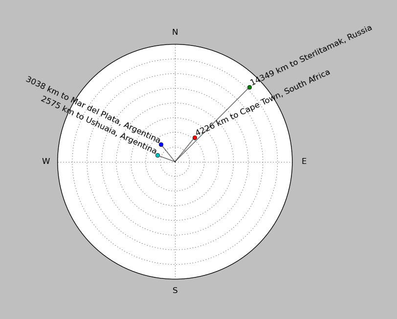
| ||||||||||||||||
Event and active stations
|
|||||||||||||||||
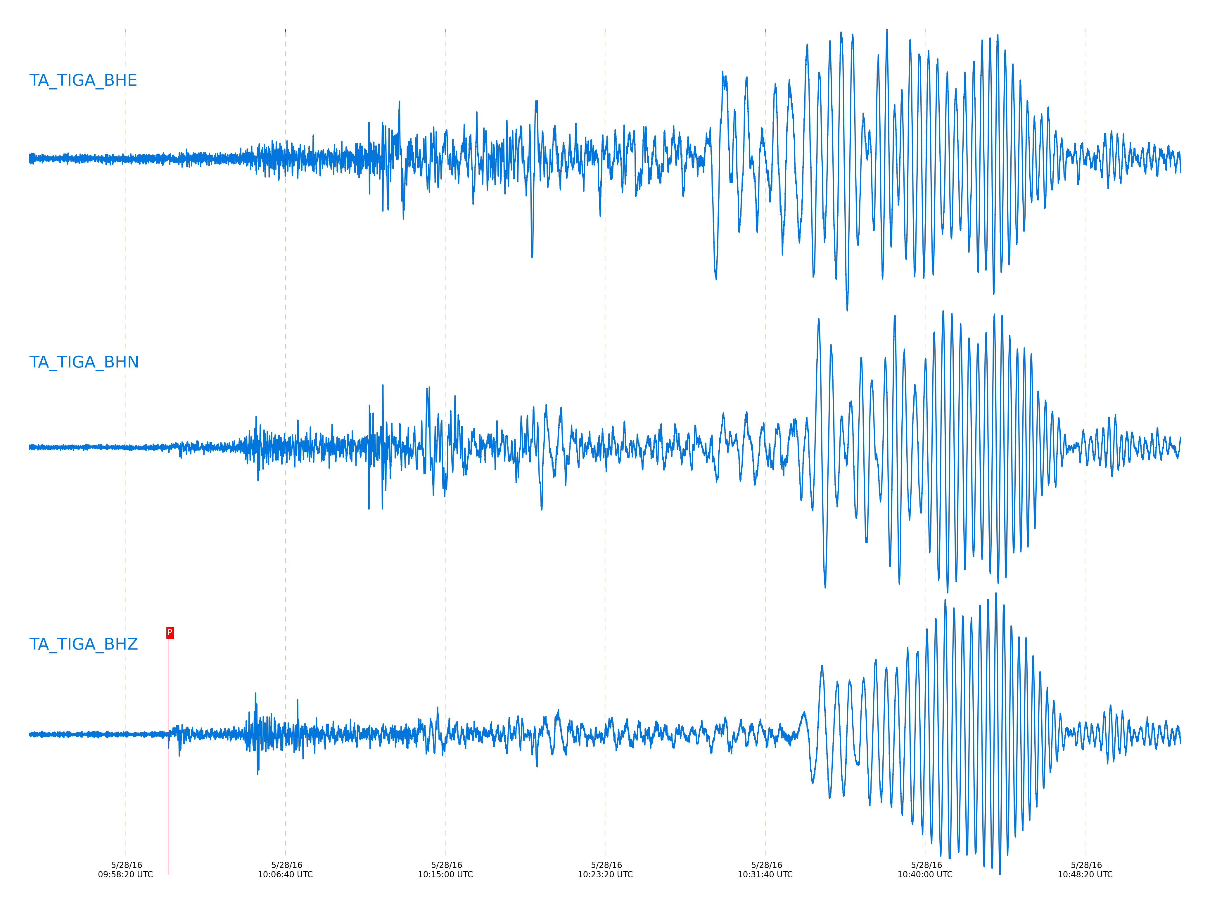
Seismic waveforms for closest station
Closest station with identified signal. Not filtered.
Seismic waveforms for vertical channels in network
Subset of several stations close to the event. Not filtered.
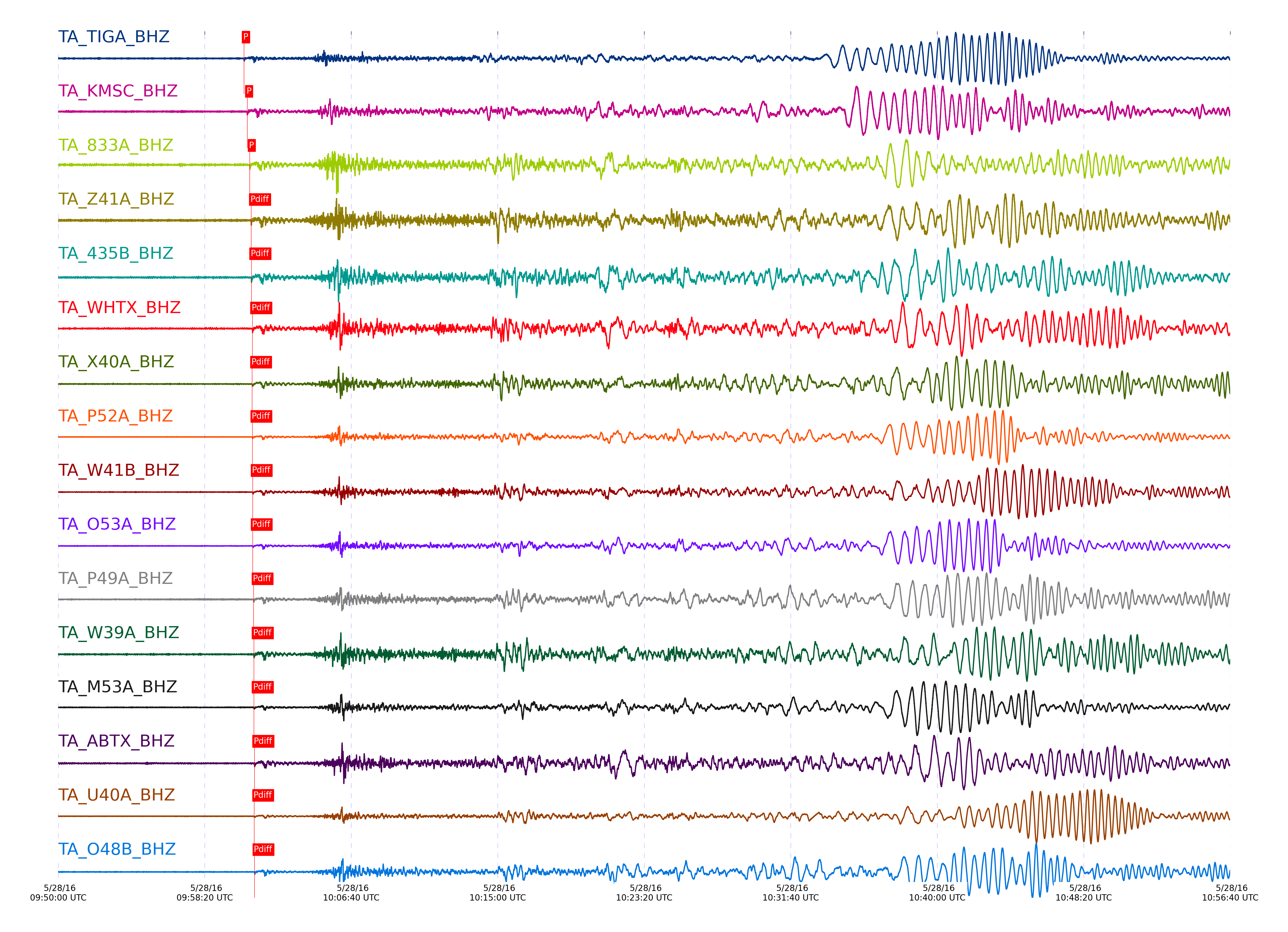
Signal description at some stations
| STA_CHAN | S-E Delta | S-E Azimuth | Phase | Time | Signal/Noise | Time Residual | V. Model | Auth | arid |
|---|---|---|---|---|---|---|---|---|---|
| TIGA_BHZ | 99.955° | 151.84° | Pdiff | 2016-05-28 10:00:34.2875 UTC | -1 | -1.602 | iasp91 | dbp:mcwhite:161 | 2992949 |
| KMSC_BHZ | 102.346° | 152.4° | Pdiff | 2016-05-28 10:00:45.0416 UTC | -1 | -1.463 | iasp91 | dbp:mcwhite:161 | 2992954 |
| 833A_BHZ | 104.303° | 146.81° | Pdiff | 2016-05-28 10:00:53.9469 UTC | -1 | -1.243 | iasp91 | dbp:mcwhite:161 | 2992962 |
| Z41A_BHZ | 105.419° | 148.21° | Pdiff | 2016-05-28 10:00:58.5544 UTC | -1 | -1.592 | iasp91 | dbp:mcwhite:161 | 2992973 |
| 435B_BHZ | 105.503° | 146.99° | Pdiff | 2016-05-28 10:00:59.3464 UTC | -1 | -1.173 | iasp91 | dbp:mcwhite:161 | 2992974 |
| WHTX_BHZ | 106.456° | 146.84° | Pdiff | 2016-05-28 10:01:02.9722 UTC | -1 | -1.776 | iasp91 | dbp:mcwhite:161 | 2992980 |
| X40A_BHZ | 106.477° | 148.02° | Pdiff | 2016-05-28 10:01:02.1885 UTC | -1 | -2.653 | iasp91 | dbp:mcwhite:161 | 2992981 |
| P52A_BHZ | 106.609° | 151.52° | Pdiff | 2016-05-28 10:01:03.1168 UTC | -1 | -2.312 | iasp91 | dbp:mcwhite:161 | 2992982 |
| W41B_BHZ | 106.805° | 148.12° | Pdiff | 2016-05-28 10:01:04.1019 UTC | -1 | -2.195 | iasp91 | dbp:mcwhite:161 | 2992984 |
| O53A_BHZ | 106.817° | 151.83° | Pdiff | 2016-05-28 10:01:04.2491 UTC | -1 | -2.101 | iasp91 | dbp:mcwhite:161 | 2992985 |
| P49A_BHZ | 107.489° | 150.42° | Pdiff | 2016-05-28 10:01:07.0728 UTC | -1 | -2.26 | iasp91 | dbp:mcwhite:161 | 2992990 |
| W39A_BHZ | 107.492° | 147.56° | Pdiff | 2016-05-28 10:01:07.5172 UTC | -1 | -1.831 | iasp91 | dbp:mcwhite:161 | 2992989 |
| M53A_BHZ | 107.674° | 151.9° | Pdiff | 2016-05-28 10:01:07.8956 UTC | -1 | -2.261 | iasp91 | dbp:mcwhite:161 | 2993000 |
| ABTX_BHZ | 108.005° | 146.04° | Pdiff | 2016-05-28 10:01:09.9455 UTC | -1 | -1.678 | iasp91 | dbp:mcwhite:161 | 2993001 |
| U40A_BHZ | 108.068° | 147.7° | Pdiff | 2016-05-28 10:01:09.3405 UTC | -1 | -2.563 | iasp91 | dbp:mcwhite:161 | 2993003 |
| O48B_BHZ | 108.284° | 150.12° | Pdiff | 2016-05-28 10:01:10.1391 UTC | -1 | -2.722 | iasp91 | dbp:mcwhite:161 | 2993004 |
| TUL1_BHZ | 108.979° | 146.72° | Pdiff | 2016-05-28 10:01:13.6438 UTC | -1 | -2.302 | iasp91 | dbp:mcwhite:161 | 2993007 |
| SFIN_BHZ | 109.136° | 149.27° | Pdiff | 2016-05-28 10:01:13.8724 UTC | -1 | -2.771 | iasp91 | dbp:mcwhite:161 | 2993008 |
| MSTX_BHZ | 110.597° | 144.81° | Pdiff | 2016-05-28 10:01:21.6046 UTC | -1 | -1.525 | iasp91 | dbp:mcwhite:161 | 2993019 |
| L44A_BHZ | 110.993° | 148.59° | Pdiff | 2016-05-28 10:01:22.7724 UTC | -1 | -2.115 | iasp91 | dbp:mcwhite:161 | 2993021 |
| 121A_BHZ | 111.88° | 143.71° | Pdiff | 2016-05-28 10:01:26.4437 UTC | -1 | -2.383 | iasp91 | dbp:mcwhite:161 | 2993022 |
| T25A_BHZ | 113.947° | 143.54° | Pdiff | 2016-05-28 10:01:37.1799 UTC | -1 | -0.819 | iasp91 | dbp:mcwhite:161 | 2993029 |
| 214A_BHZ | 113.969° | 142.61° | Pdiff | 2016-05-28 10:01:37.1959 UTC | -1 | -0.902 | iasp91 | dbp:mcwhite:161 | 2993030 |
| BGNE_BHZ | 114.557° | 144.61° | Pdiff | 2016-05-28 10:01:38.6251 UTC | -1 | -2.084 | iasp91 | dbp:mcwhite:161 | 2993031 |
| KSCO_BHZ | 114.62° | 143.63° | Pdiff | 2016-05-28 10:01:39.8786 UTC | -1 | -1.109 | iasp91 | dbp:mcwhite:161 | 2993032 |
| W18A_BHZ | 114.921° | 142.51° | Pdiff | 2016-05-28 10:01:41.1977 UTC | -1 | -1.126 | iasp91 | dbp:mcwhite:161 | 2993033 |
| SPMN_BHZ | 115.468° | 145.77° | Pdiff | 2016-05-28 10:01:42.1724 UTC | -1 | -2.58 | iasp91 | dbp:mcwhite:161 | 2993034 |
| S22A_BHZ | 115.586° | 142.61° | Pdiff | 2016-05-28 10:01:46.6874 UTC | -1 | 1.413 | iasp91 | dbp:mcwhite:161 | 2993035 |
| S22A_BHZ | 115.586° | 142.61° | PKPdf | 2016-05-28 10:05:31.5555 UTC | -1 | -1.296 | iasp91 | dbp:mcwhite:161 | 2993586 |
| Q24A_BHZ | 115.756° | 142.79° | Pdiff | 2016-05-28 10:01:44.9805 UTC | -1 | -1.051 | iasp91 | dbp:mcwhite:161 | 2993036 |
| Q24A_BHZ | 115.756° | 142.79° | PKPdf | 2016-05-28 10:05:31.3308 UTC | -1 | -1.848 | iasp91 | dbp:mcwhite:161 | 2993587 |
| 109C_BHZ | 116.935° | 141.4° | Pdiff | 2016-05-28 10:01:52.5945 UTC | -1 | 1.329 | iasp91 | dbp:mcwhite:161 | 2993336 |
| 109C_BHZ | 116.935° | 141.4° | PKPdf | 2016-05-28 10:05:34.2619 UTC | -1 | -1.174 | iasp91 | dbp:mcwhite:161 | 2993577 |
| SUSD_BHZ | 117.359° | 143.43° | Pdiff | 2016-05-28 10:01:51.069 UTC | -1 | -2.079 | iasp91 | dbp:mcwhite:161 | 2993340 |
| SUSD_BHZ | 117.359° | 143.43° | PKPdf | 2016-05-28 10:05:33.7149 UTC | -1 | -2.533 | iasp91 | dbp:mcwhite:161 | 2993582 |
| N23A_BHZ | 117.657° | 141.93° | Pdiff | 2016-05-28 10:01:54.0141 UTC | -1 | -0.456 | iasp91 | dbp:mcwhite:161 | 2993343 |
| N23A_BHZ | 117.657° | 141.93° | PKPdf | 2016-05-28 10:05:34.9726 UTC | -1 | -1.845 | iasp91 | dbp:mcwhite:161 | 2993585 |
| O20A_BHZ | 118.144° | 141.42° | Pdiff | 2016-05-28 10:01:55.4278 UTC | -1 | -1.205 | iasp91 | dbp:mcwhite:161 | 2993346 |
| O20A_BHZ | 118.144° | 141.42° | PKPdf | 2016-05-28 10:05:35.7975 UTC | -1 | -1.953 | iasp91 | dbp:mcwhite:161 | 2993567 |
| K22A_BHZ | 119.301° | 141.14° | Pdiff | 2016-05-28 10:02:00.9899 UTC | -1 | -0.778 | iasp91 | dbp:mcwhite:161 | 2993358 |
| K22A_BHZ | 119.301° | 141.14° | PKPdf | 2016-05-28 10:05:37.0877 UTC | -1 | -2.875 | iasp91 | dbp:mcwhite:161 | 2993557 |
| MDND_BHZ | 120.341° | 142.02° | Pdiff | 2016-05-28 10:02:04.6073 UTC | -1 | -1.775 | iasp91 | dbp:mcwhite:161 | 2993366 |
| MDND_BHZ | 120.341° | 142.02° | PKPdf | 2016-05-28 10:05:38.9193 UTC | -1 | -3.031 | iasp91 | dbp:mcwhite:161 | 2993547 |
| R11A_BHZ | 120.375° | 139.87° | Pdiff | 2016-05-28 10:02:04.2246 UTC | -1 | -2.307 | iasp91 | dbp:mcwhite:161 | 2993367 |
| R11A_BHZ | 120.375° | 139.87° | PKPdf | 2016-05-28 10:05:41.0748 UTC | -1 | -0.94 | iasp91 | dbp:mcwhite:161 | 2993548 |
| H17A_BHZ | 122.524° | 139.03° | Pdiff | 2016-05-28 10:02:13.8913 UTC | -1 | -2.182 | iasp91 | dbp:mcwhite:161 | 2993373 |
| H17A_BHZ | 122.524° | 139.03° | PKPdf | 2016-05-28 10:05:45.1107 UTC | -1 | -1.009 | iasp91 | dbp:mcwhite:161 | 2993533 |
| L04D_BHZ | 126.674° | 136.33° | PKPdf | 2016-05-28 10:05:52.2969 UTC | -1 | -1.719 | iasp91 | dbp:mcwhite:161 | 2993539 |
| K04D_BHZ | 126.687° | 136.28° | Pdiff | 2016-05-28 10:02:33.5726 UTC | -1 | -0.978 | iasp91 | dbp:mcwhite:161 | 2993379 |
| K04D_BHZ | 126.687° | 136.28° | PKPdf | 2016-05-28 10:05:52.6882 UTC | -1 | -1.352 | iasp91 | dbp:mcwhite:161 | 2993540 |
| J05D_BHZ | 126.9° | 136.09° | Pdiff | 2016-05-28 10:02:34.12 UTC | -1 | -1.379 | iasp91 | dbp:mcwhite:161 | 2993380 |
| J05D_BHZ | 126.9° | 136.09° | PKPdf | 2016-05-28 10:05:53.0956 UTC | -1 | -1.35 | iasp91 | dbp:mcwhite:161 | 2993541 |
| L02F_BHZ | 127.253° | 136.05° | PKPdf | 2016-05-28 10:05:53.8492 UTC | -1 | -1.265 | iasp91 | dbp:mcwhite:161 | 2993519 |
| J04D_BHZ | 127.311° | 135.86° | PKPdf | 2016-05-28 10:05:54.055 UTC | -1 | -1.169 | iasp91 | dbp:mcwhite:161 | 2993520 |
| I05D_BHZ | 127.708° | 135.49° | PKPdf | 2016-05-28 10:05:54.857 UTC | -1 | -1.119 | iasp91 | dbp:mcwhite:161 | 2993521 |
| K02D_BHZ | 127.715° | 135.71° | PKPdf | 2016-05-28 10:05:54.8152 UTC | -1 | -1.173 | iasp91 | dbp:mcwhite:161 | 2993522 |
| I04A_BHZ | 127.86° | 135.47° | PKPdf | 2016-05-28 10:05:54.275 UTC | -1 | -1.989 | iasp91 | dbp:mcwhite:161 | 2993523 |
| J01E_BHZ | 128.184° | 135.39° | PKPdf | 2016-05-28 10:05:55.0198 UTC | -1 | -1.856 | iasp91 | dbp:mcwhite:161 | 2993524 |
| I03D_BHZ | 128.267° | 135.25° | PKPdf | 2016-05-28 10:05:55.3164 UTC | -1 | -1.717 | iasp91 | dbp:mcwhite:161 | 2993525 |
| G05D_BHZ | 128.339° | 135° | PKPdf | 2016-05-28 10:05:55.7786 UTC | -1 | -1.39 | iasp91 | dbp:mcwhite:161 | 2993526 |
| H04D_BHZ | 128.543° | 134.97° | PKPdf | 2016-05-28 10:05:56.0232 UTC | -1 | -1.532 | iasp91 | dbp:mcwhite:161 | 2993528 |
| I02E_BHZ | 128.811° | 134.88° | PKPdf | 2016-05-28 10:05:56.2543 UTC | -1 | -1.808 | iasp91 | dbp:mcwhite:161 | 2993529 |
| F05D_BHZ | 128.863° | 134.59° | PKPdf | 2016-05-28 10:05:56.6337 UTC | -1 | -1.526 | iasp91 | dbp:mcwhite:161 | 2993530 |
| G03D_BHZ | 129.292° | 134.41° | PKPdf | 2016-05-28 10:05:57.7123 UTC | -1 | -1.257 | iasp91 | dbp:mcwhite:161 | 2993514 |
| F04D_BHZ | 129.772° | 133.98° | PKPdf | 2016-05-28 10:05:59.2138 UTC | -1 | -0.662 | iasp91 | dbp:mcwhite:161 | 2993515 |
| E04D_BHZ | 129.88° | 133.84° | PKPdf | 2016-05-28 10:05:58.3705 UTC | -1 | -1.708 | iasp91 | dbp:mcwhite:161 | 2993516 |
| D04E_BHZ | 130.41° | 133.39° | PKPdf | 2016-05-28 10:06:00.3728 UTC | -1 | -0.704 | iasp91 | dbp:mcwhite:161 | 2993517 |
| D03D_BHZ | 130.811° | 133.06° | Pdiff | 2016-05-28 10:02:52.3367 UTC | -1 | -0.522 | iasp91 | dbp:mcwhite:161 | 2993382 |
| D03D_BHZ | 130.811° | 133.06° | PKPdf | 2016-05-28 10:06:00.899 UTC | -1 | -0.931 | iasp91 | dbp:mcwhite:161 | 2993518 |
| T35M_BHZ | 140.069° | 122.52° | PKPdf | 2016-05-28 10:06:07.2004 UTC | -1 | -11.694 | iasp91 | dbp:mcwhite:161 | 2993512 |
| S34M_BHZ | 140.964° | 121.12° | Pdiff | 2016-05-28 10:03:39.2609 UTC | -1 | 1.335 | iasp91 | dbp:mcwhite:161 | 2993385 |
| S34M_BHZ | 140.964° | 121.12° | PKPdf | 2016-05-28 10:06:09.5225 UTC | -1 | -10.97 | iasp91 | dbp:mcwhite:161 | 2993511 |
| P33M_BHZ | 142.848° | 117.66° | Pdiff | 2016-05-28 10:03:43.5166 UTC | -1 | -2.771 | iasp91 | dbp:mcwhite:161 | 2993387 |
| P33M_BHZ | 142.848° | 117.66° | PKPdf | 2016-05-28 10:06:16.3896 UTC | -1 | -7.426 | iasp91 | dbp:mcwhite:161 | 2993506 |
| C36M_BHZ | 143.334° | 112.45° | PKPdf | 2016-05-28 10:06:16.7784 UTC | -1 | -7.884 | iasp91 | dbp:mcwhite:161 | 2993504 |
| M31M_BHZ | 144.401° | 114.31° | Pdiff | 2016-05-28 10:03:53.9755 UTC | -1 | 0.791 | iasp91 | dbp:mcwhite:161 | 2993389 |
| M31M_BHZ | 144.401° | 114.31° | PKPdf | 2016-05-28 10:06:22.7685 UTC | -1 | -3.738 | iasp91 | dbp:mcwhite:161 | 2993499 |
| O30N_BHZ | 144.54° | 115.11° | PKPbc | 2016-05-28 10:06:22.2792 UTC | -1 | -2.944 | iasp91 | dbp:mcwhite:161 | 2993498 |
| A36M_BHZ | 144.615° | 108.12° | Pdiff | 2016-05-28 10:03:54.739 UTC | -1 | 0.606 | iasp91 | dbp:mcwhite:161 | 2993390 |
| A36M_BHZ | 144.615° | 108.12° | PKPbc | 2016-05-28 10:06:23.0801 UTC | -1 | -2.396 | iasp91 | dbp:mcwhite:161 | 2993497 |
| N31M_BHZ | 144.703° | 114.38° | PKPbc | 2016-05-28 10:06:22.5452 UTC | -1 | -3.227 | iasp91 | dbp:mcwhite:161 | 2993485 |
| N30M_BHZ | 145.263° | 113.62° | PKPbc | 2016-05-28 10:06:24.5061 UTC | -1 | -3.088 | iasp91 | dbp:mcwhite:161 | 2993487 |
| M30M_BHZ | 145.572° | 112.32° | PKPdf | 2016-05-28 10:06:24.6892 UTC | -1 | -3.811 | iasp91 | dbp:mcwhite:161 | 2993489 |
| EPYK_BHZ | 146.821° | 107.03° | PKPdf | 2016-05-28 10:06:25.9306 UTC | -1 | -4.659 | iasp91 | dbp:mcwhite:161 | 2993496 |
| J29M_BHZ | 146.824° | 108.75° | PKPdf | 2016-05-28 10:06:26.6488 UTC | -1 | -3.948 | iasp91 | dbp:mcwhite:161 | 2993495 |
| I29M_BHZ | 147.142° | 107.36° | PKPdf | 2016-05-28 10:06:26.3806 UTC | -1 | -4.741 | iasp91 | dbp:mcwhite:161 | 2993476 |
| M27K_BHZ | 147.69° | 109.39° | PKPdf | 2016-05-28 10:06:27.8661 UTC | -1 | -4.156 | iasp91 | dbp:mcwhite:161 | 2993480 |
| L27K_BHZ | 147.896° | 108.36° | PKPdf | 2016-05-28 10:06:28.0847 UTC | -1 | -4.273 | iasp91 | dbp:mcwhite:161 | 2993482 |
| M26K_BHZ | 148.195° | 108.6° | PKPdf | 2016-05-28 10:06:28.5655 UTC | -1 | -4.277 | iasp91 | dbp:mcwhite:161 | 2993484 |
| K27K_BHZ | 148.293° | 106.71° | PKPdf | 2016-05-28 10:06:28.9741 UTC | -1 | -4.027 | iasp91 | dbp:mcwhite:161 | 2993461 |
| L26K_BHZ | 148.541° | 107.4° | PKPdf | 2016-05-28 10:06:29.1271 UTC | -1 | -4.274 | iasp91 | dbp:mcwhite:161 | 2993463 |
| N25K_BHZ | 148.652° | 108.8° | PKPdf | 2016-05-28 10:06:29.6599 UTC | -1 | -3.92 | iasp91 | dbp:mcwhite:161 | 2993464 |
| Q23K_BHZ | 148.715° | 111.13° | PKPdf | 2016-05-28 10:06:29.0262 UTC | -1 | -4.654 | iasp91 | dbp:mcwhite:161 | 2993465 |
| J26L_BHZ | 149.043° | 104.91° | PKPdf | 2016-05-28 10:06:29.6979 UTC | -1 | -4.508 | iasp91 | dbp:mcwhite:161 | 2993467 |
| HARP_BHZ | 149.146° | 107.19° | PKPdf | 2016-05-28 10:06:29.61 UTC | -1 | -4.76 | iasp91 | dbp:mcwhite:161 | 2993469 |
| M24K_BHZ | 149.514° | 107° | PKPdf | 2016-05-28 10:06:30.913 UTC | -1 | -4.039 | iasp91 | dbp:mcwhite:161 | 2993460 |
| K24K_BHZ | 149.8° | 104.48° | PKPdf | 2016-05-28 10:06:30.2884 UTC | -1 | -5.115 | iasp91 | dbp:mcwhite:161 | 2993458 |
| J25K_BHZ | 149.823° | 103.42° | PKPdf | 2016-05-28 10:06:30.4485 UTC | -1 | -4.99 | iasp91 | dbp:mcwhite:161 | 2993457 |
| M23K_BHZ | 150.122° | 106.51° | PKPdf | 2016-05-28 10:06:31.0212 UTC | -1 | -4.884 | iasp91 | dbp:mcwhite:161 | 2993455 |
| O22K_BHZ | 150.661° | 107.46° | PKPdf | 2016-05-28 10:06:31.9706 UTC | -1 | -4.771 | iasp91 | dbp:mcwhite:161 | 2993437 |
| POKR_BHZ | 150.786° | 101.01° | PKPdf | 2016-05-28 10:06:31.3435 UTC | -1 | -5.591 | iasp91 | dbp:mcwhite:161 | 2993440 |
| TCOL_BHZ | 150.917° | 101.12° | PKPdf | 2016-05-28 10:06:31.061 UTC | -1 | -6.074 | iasp91 | dbp:mcwhite:161 | 2993445 |
| H24K_BHZ | 151.096° | 99.39° | PKPdf | 2016-05-28 10:06:32.3022 UTC | -1 | -5.105 | iasp91 | dbp:mcwhite:161 | 2993446 |
| M22K_BHZ | 151.201° | 105.01° | PKPdf | 2016-05-28 10:06:32.5616 UTC | -1 | -5.006 | iasp91 | dbp:mcwhite:161 | 2993426 |
| Q20K_BHZ | 151.359° | 109.13° | PKPdf | 2016-05-28 10:06:32.5454 UTC | -1 | -5.263 | iasp91 | dbp:mcwhite:161 | 2993429 |
| I23K_BHZ | 151.589° | 99.47° | PKPdf | 2016-05-28 10:06:32.2035 UTC | -1 | -5.953 | iasp91 | dbp:mcwhite:161 | 2993433 |
| H23K_BHZ | 151.768° | 98.09° | PKPdf | 2016-05-28 10:06:33.1981 UTC | -1 | -5.226 | iasp91 | dbp:mcwhite:161 | 2993435 |
| O20K_BHZ | 151.92° | 106.4° | PKPdf | 2016-05-28 10:06:32.915 UTC | -1 | -5.738 | iasp91 | dbp:mcwhite:161 | 2993436 |
| TOLK_BHZ | 152.046° | 92.81° | PKPdf | 2016-05-28 10:06:34.1118 UTC | -1 | -4.73 | iasp91 | dbp:mcwhite:161 | 2993417 |
| Q19K_BHZ | 152.075° | 107.88° | PKPdf | 2016-05-28 10:06:33.6225 UTC | -1 | -5.262 | iasp91 | dbp:mcwhite:161 | 2993416 |
| M20K_BHZ | 152.612° | 102.76° | PKPdf | 2016-05-28 10:06:33.7087 UTC | -1 | -5.97 | iasp91 | dbp:mcwhite:161 | 2993423 |
| I21K_BHZ | 152.683° | 97.34° | PKPdf | 2016-05-28 10:06:34.0709 UTC | -1 | -5.712 | iasp91 | dbp:mcwhite:161 | 2993425 |
| O19K_BHZ | 152.764° | 105.16° | PKPdf | 2016-05-28 10:06:33.6811 UTC | -1 | -6.22 | iasp91 | dbp:mcwhite:161 | 2993403 |
| P18K_BHZ | 152.988° | 106.13° | PKPdf | 2016-05-28 10:06:34.0038 UTC | -1 | -6.224 | iasp91 | dbp:mcwhite:161 | 2993404 |
| N19K_BHZ | 152.997° | 103.89° | PKPdf | 2016-05-28 10:06:32.5783 UTC | -1 | -7.663 | iasp91 | dbp:mcwhite:161 | 2993405 |
| L20K_BHZ | 153.077° | 101.1° | PKPdf | 2016-05-28 10:06:33.7879 UTC | -1 | -6.57 | iasp91 | dbp:mcwhite:161 | 2993406 |
| H21K_BHZ | 153.078° | 95.74° | PKPdf | 2016-05-28 10:06:34.1228 UTC | -1 | -6.236 | iasp91 | dbp:mcwhite:161 | 2993407 |
| M19K_BHZ | 153.197° | 101.86° | PKPdf | 2016-05-28 10:06:34.2757 UTC | -1 | -6.255 | iasp91 | dbp:mcwhite:161 | 2993408 |
| K20K_BHZ | 153.318° | 99.25° | PKPdf | 2016-05-28 10:06:34.4577 UTC | -1 | -6.248 | iasp91 | dbp:mcwhite:161 | 2993409 |
| L19K_BHZ | 153.464° | 100.99° | PKPdf | 2016-05-28 10:06:34.874 UTC | -1 | -6.043 | iasp91 | dbp:mcwhite:161 | 2993410 |
| J20K_BHZ | 153.471° | 97.58° | PKPdf | 2016-05-28 10:06:35.1051 UTC | -1 | -5.821 | iasp91 | dbp:mcwhite:161 | 2993411 |
| N18K_BHZ | 153.633° | 103.24° | PKPdf | 2016-05-28 10:06:34.8972 UTC | -1 | -6.262 | iasp91 | dbp:mcwhite:161 | 2993413 |
| A21K_BHZ | 154.303° | 80.62° | PKPdf | 2016-05-28 10:06:36.5512 UTC | -1 | -5.555 | iasp91 | dbp:mcwhite:161 | 2993392 |
External resources
Current seismic activity measured by the seismic network
Click the link below to observe an interactive map of earthquakes recorded by the station deployment: