last update to page: April 25 2017 16:49:59 (UTC).
Magnitude 6.9 Earthquake: Off Coast Of Central Chile
SummaryThe red marker denotes the earthquake epicenter. On Mon Apr 24th 2017 21:38:26 (UTC) the seismic network recorded an earthquake (preliminary 6.9 mww) located in Off Coast Of Central Chile. Seismic region Andean South America. The epicentral distance (i.e. distance separating the location to the epicenter) to the closest station TIGA in the network is 7,283.2 km. If you felt the quake, the USGS would like to know. Please add your comments to the USGS page "Did you feel it?". |
Details
Proximity to Population Centers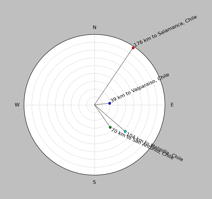
| ||||||||||||||||
Event and active stations
|
|||||||||||||||||
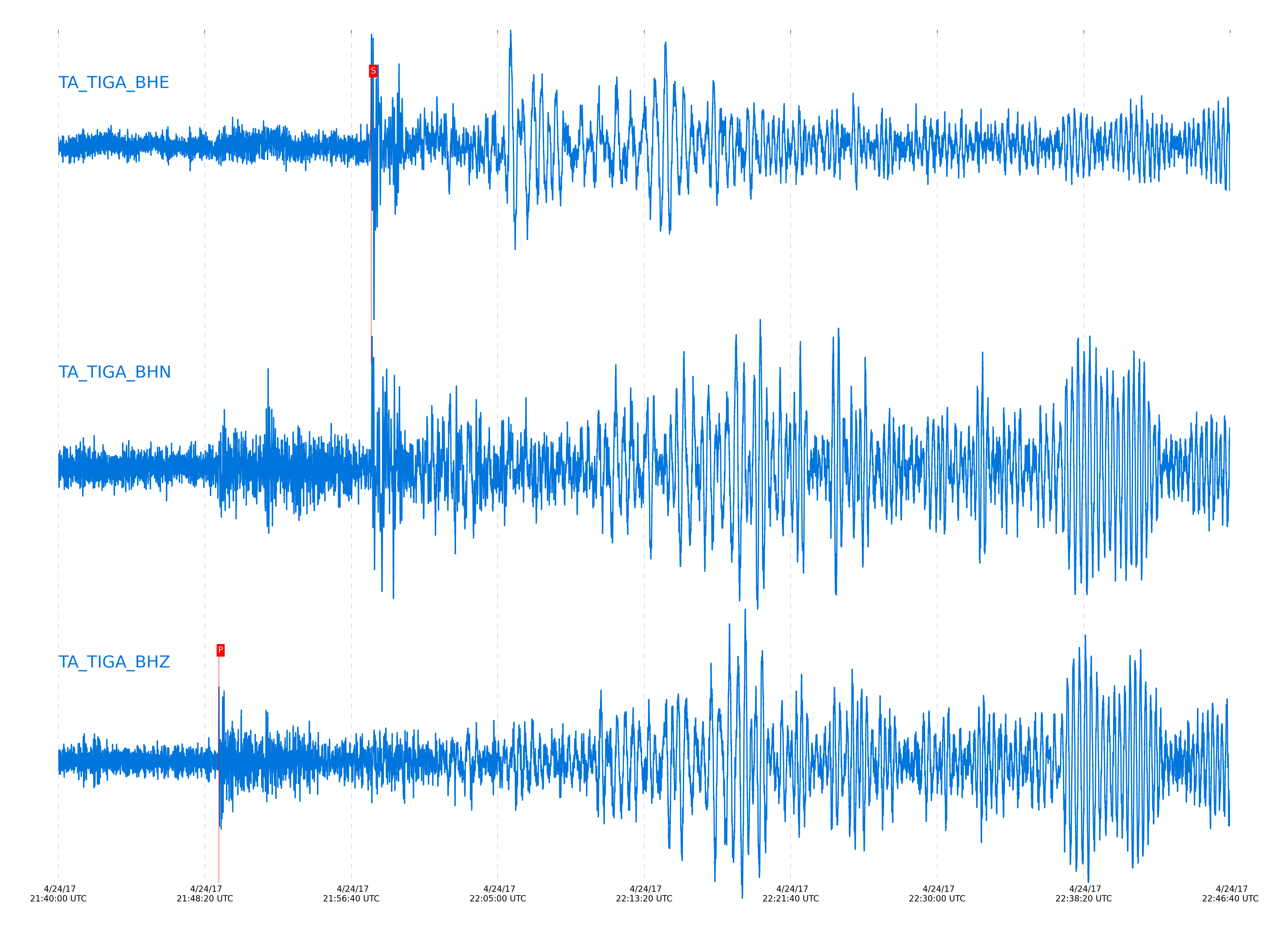
Seismic waveforms for closest station
Closest station with identified signal. Not filtered.
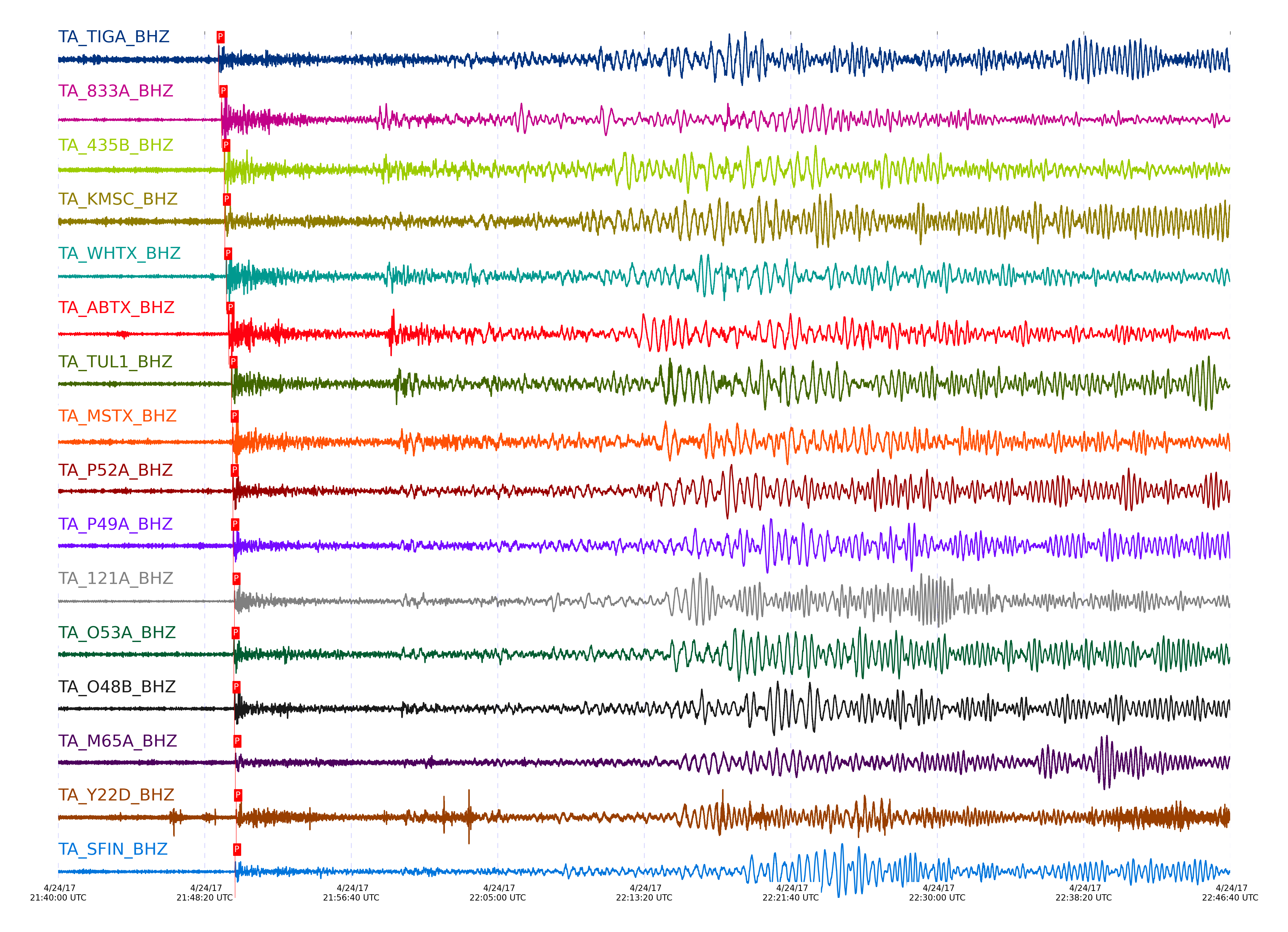
Seismic waveforms for vertical channels in network
Subset of several stations close to the event. Not filtered.
Signal description at some stations
| STA_CHAN | S-E Delta | S-E Azimuth | Phase | Time | Signal/Noise | Time Residual | V. Model | Auth | arid |
|---|---|---|---|---|---|---|---|---|---|
| TIGA_BHZ | 65.425° | 169.38° | P | 2017-04-24 21:49:07.7898 UTC | -1 | 1.078 | iasp91 | dbp:jtytell:171 | 3687124 |
| 833A_BHZ | 66.651° | 155.21° | P | 2017-04-24 21:49:17.5966 UTC | 17.652 | 3.001 | iasp91 | dbp:jtytell:171 | 3686732 |
| 435B_BHZ | 68.265° | 157.12° | P | 2017-04-24 21:49:27.2598 UTC | -1 | 2.452 | iasp91 | dbp:jtytell:171 | 3687129 |
| KMSC_BHZ | 68.767° | 171.66° | P | 2017-04-24 21:49:29.1225 UTC | 11.661 | 1.17 | iasp91 | dbp:jtytell:171 | 3686736 |
| WHTX_BHZ | 69.337° | 157.4° | P | 2017-04-24 21:49:33.629 UTC | 12.751 | 2.139 | iasp91 | dbp:jtytell:171 | 3686737 |
| ABTX_BHZ | 70.652° | 155.71° | P | 2017-04-24 21:49:41.9582 UTC | 18.81 | 2.385 | iasp91 | dbp:jtytell:171 | 3686744 |
| TUL1_BHZ | 72.47° | 159.28° | P | 2017-04-24 21:49:51.8132 UTC | 12.155 | 1.28 | iasp91 | dbp:jtytell:171 | 3686750 |
| MSTX_BHZ | 72.991° | 153.41° | P | 2017-04-24 21:49:56.0282 UTC | 20.575 | 2.398 | iasp91 | dbp:jtytell:171 | 3686752 |
| P52A_BHZ | 73.304° | 171.19° | P | 2017-04-24 21:49:56.1947 UTC | 24.776 | 0.717 | iasp91 | dbp:jtytell:171 | 3686707 |
| P49A_BHZ | 73.549° | 168.96° | P | 2017-04-24 21:49:57.5645 UTC | 10.636 | 0.641 | iasp91 | dbp:jtytell:171 | 3686708 |
| 121A_BHZ | 73.739° | 149.35° | P | 2017-04-24 21:50:01.8696 UTC | 31.996 | 3.83 | iasp91 | dbp:jtytell:171 | 3686754 |
| O53A_BHZ | 73.81° | 172.01° | P | 2017-04-24 21:49:59.4099 UTC | 8.708 | 0.955 | iasp91 | dbp:jtytell:171 | 3686709 |
| O48B_BHZ | 74.323° | 168.62° | P | 2017-04-24 21:50:01.8658 UTC | 8.6312 | 0.408 | iasp91 | dbp:jtytell:171 | 3686711 |
| M65A_BHZ | 74.646° | 181.22° | P | 2017-04-24 21:50:04.8386 UTC | -1 | 1.505 | iasp91 | dbp:jtytell:171 | 3687137 |
| Y22D_BHZ | 74.707° | 150.22° | P | 2017-04-24 21:50:07.6797 UTC | -1 | 3.99 | iasp91 | dbp:jtytell:171 | 3687138 |
| Y22F_BHZ_00 | 74.708° | 150.22° | P | 2017-04-24 21:50:07.4434 UTC | -1 | 3.753 | iasp91 | dbp:jtytell:171 | 3687139 |
| SFIN_BHZ | 74.756° | 166.97° | P | 2017-04-24 21:50:03.9846 UTC | 9.5205 | 0.016 | iasp91 | dbp:jtytell:171 | 3686700 |
| M53A_BHZ | 74.934° | 172.52° | P | 2017-04-24 21:50:05.8029 UTC | 11.673 | 0.802 | iasp91 | dbp:jtytell:171 | 3686712 |
| L61B_BHZ | 75.525° | 179.46° | P | 2017-04-24 21:50:10.0717 UTC | 21.496 | 1.668 | iasp91 | dbp:jtytell:171 | 3686787 |
| 214A_BHZ | 75.54° | 145.6° | P | 2017-04-24 21:50:12.3313 UTC | -1 | 3.844 | iasp91 | dbp:jtytell:171 | 3687144 |
| T25A_BHZ | 76.42° | 152.52° | P | 2017-04-24 21:50:17.1035 UTC | 80.929 | 3.597 | iasp91 | dbp:jtytell:171 | 3686733 |
| L44A_BHZ | 76.647° | 166.39° | P | 2017-04-24 21:50:15.6895 UTC | 9.1414 | 0.894 | iasp91 | dbp:jtytell:171 | 3686713 |
| W18A_BHZ | 76.79° | 148.25° | P | 2017-04-24 21:50:19.0469 UTC | -1 | 3.448 | iasp91 | dbp:jtytell:171 | 3687147 |
| KSCO_BHZ | 77.462° | 154.11° | P | 2017-04-24 21:50:22.2626 UTC | 10.951 | 2.887 | iasp91 | dbp:jtytell:171 | 3686701 |
| S22A_BHZ | 77.867° | 150.73° | P | 2017-04-24 21:50:25.1564 UTC | 11.3 | 3.526 | iasp91 | dbp:jtytell:171 | 3686714 |
| BGNE_BHZ | 78.26° | 157.88° | P | 2017-04-24 21:50:25.5915 UTC | 8.9493 | 1.779 | iasp91 | dbp:jtytell:171 | 3686703 |
| Q24A_BHZ | 78.306° | 152.14° | P | 2017-04-24 21:50:27.4358 UTC | 33.152 | 3.367 | iasp91 | dbp:jtytell:171 | 3686702 |
| 109C_BHZ | 78.418° | 142.74° | P | 2017-04-24 21:50:28.3841 UTC | -1 | 3.701 | iasp91 | dbp:jtytell:171 | 3687151 |
| TPFO_BHZ | 78.663° | 143.27° | pP | 2017-04-24 21:50:30.3673 UTC | 17.27 | -3.728 | iasp91 | dbp:jtytell:171 | 3686720 |
| N23A_BHZ | 80.297° | 151.7° | P | 2017-04-24 21:50:37.8992 UTC | 16.568 | 2.98 | iasp91 | dbp:jtytell:171 | 3686725 |
| O20A_BHZ | 80.486° | 149.89° | P | 2017-04-24 21:50:38.839 UTC | 16.23 | 2.904 | iasp91 | dbp:jtytell:171 | 3686727 |
| SPMN_BHZ | 80.53° | 162.48° | P | 2017-04-24 21:50:36.6891 UTC | -1 | 0.519 | iasp91 | dbp:jtytell:171 | 3687163 |
| SUSD_BHZ | 81.291° | 157.44° | P | 2017-04-24 21:50:41.782 UTC | -1 | 1.554 | iasp91 | dbp:jtytell:171 | 3687168 |
| K22A_BHZ | 82.046° | 151.39° | PcP | 2017-04-24 21:50:47.1964 UTC | 21.989 | -2.222 | iasp91 | dbp:jtytell:171 | 3686731 |
| R11B_BHZ | 82.077° | 144.36° | PcP | 2017-04-24 21:50:48.1553 UTC | 26.981 | -1.395 | iasp91 | dbp:jtytell:171 | 3686807 |
| MDND_BHZ | 84.605° | 157.09° | PcP | 2017-04-24 21:50:59.168 UTC | 10.173 | -1.478 | iasp91 | dbp:jtytell:171 | 3686809 |
| H17A_BHZ | 85.029° | 148.41° | PcP | 2017-04-24 21:51:02.9666 UTC | -1 | 0.458 | iasp91 | dbp:jtytell:171 | 3687179 |
External resources
Current seismic activity measured by the seismic network
Click the link below to observe an interactive map of earthquakes recorded by the station deployment: