last update to page: November 02 2016 22:54:12 (UTC).
Magnitude 4.1 Earthquake: Oklahoma
SummaryThe red marker denotes the earthquake epicenter. On Wed Nov 2nd 2016 04:26:54 (UTC) the seismic network recorded an earthquake (preliminary 4.1 mb) located in Oklahoma. Seismic region Eastern North America. The epicentral distance (i.e. distance separating the location to the epicenter) to the closest station TUL1 in the network is 90.8 km. If you felt the quake, the USGS would like to know. Please add your comments to the USGS page "Did you feel it?". |
Details
Proximity to Population Centers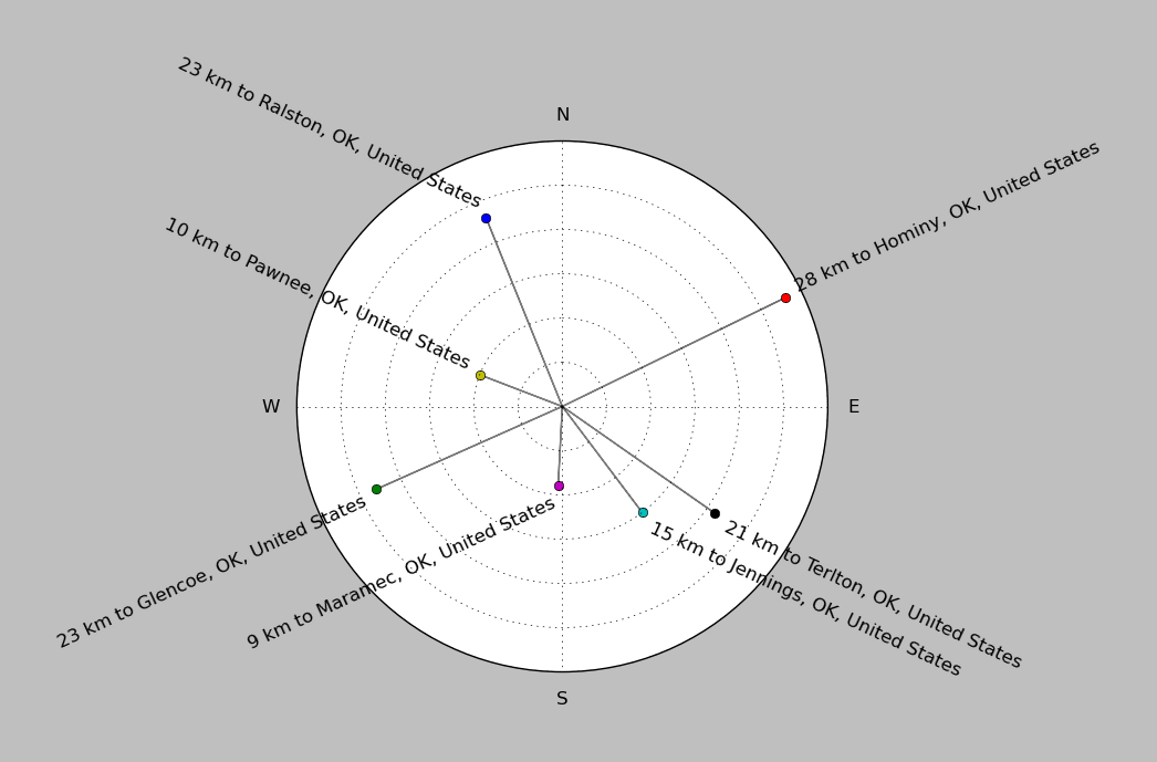
| ||||||||||||||||
Event and active stations
|
|||||||||||||||||
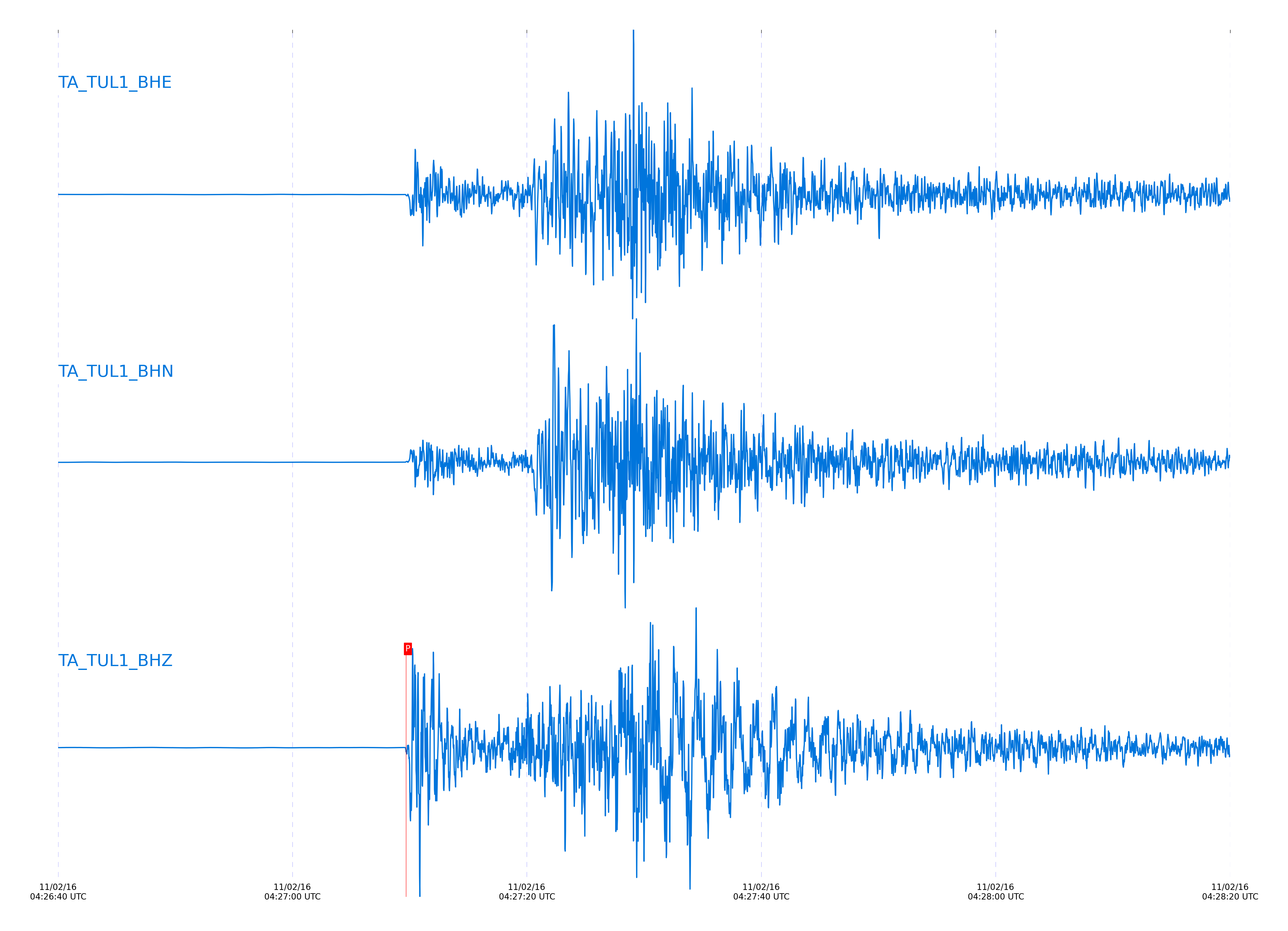
Seismic waveforms for closest station
Closest station with identified signal. Not filtered.
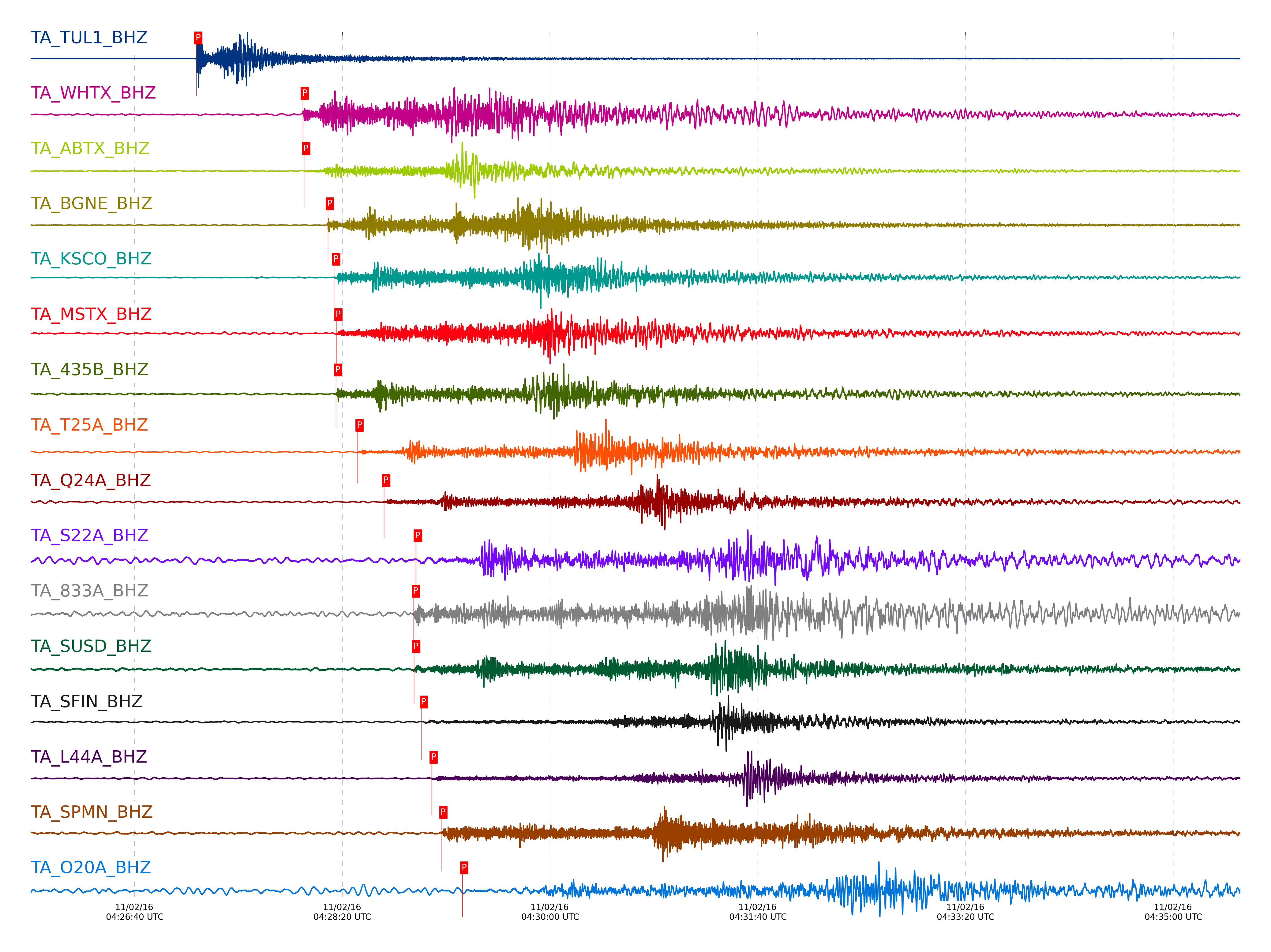
Seismic waveforms for vertical channels in network
Subset of several stations close to the event. Not filtered.
Signal description at some stations
| STA_CHAN | S-E Delta | S-E Azimuth | Phase | Time | Signal/Noise | Time Residual | V. Model | Auth | arid |
|---|---|---|---|---|---|---|---|---|---|
| TUL1_BHZ | 0.815° | 298.76° | Pg | 2016-11-02 04:27:09.6823 UTC | 6729 | -0.445 | iasp91 | dbp:vladik:1630 | 3338401 |
| WHTX_BHZ | 4.356° | 8.28° | Pn | 2016-11-02 04:28:00.9457 UTC | 41.448 | 0.216 | iasp91 | dbp:vladik:1630 | 3338411 |
| ABTX_BHZ | 4.413° | 32.79° | Pn | 2016-11-02 04:28:01.6188 UTC | 10.787 | 0.098 | iasp91 | dbp:vladik:1630 | 3338413 |
| BGNE_BHZ | 5.235° | 166.89° | Pn | 2016-11-02 04:28:13.025 UTC | 120.3 | 0.207 | iasp91 | dbp:vladik:1630 | 3338415 |
| KSCO_BHZ | 5.433° | 118.09° | Pn | 2016-11-02 04:28:16.0485 UTC | 46.459 | 0.522 | iasp91 | dbp:vladik:1630 | 3338417 |
| MSTX_BHZ | 5.5° | 63.21° | Pn | 2016-11-02 04:28:17.1349 UTC | 16.103 | 0.688 | iasp91 | dbp:vladik:1630 | 3338390 |
| 435B_BHZ | 5.568° | 7.55° | Pn | 2016-11-02 04:28:16.9445 UTC | -1 | -0.445 | iasp91 | dbp:vladik:1630 | 3339394 |
| T25A_BHZ | 6.252° | 95.39° | Pn | 2016-11-02 04:28:27.3123 UTC | 146.79 | 0.523 | iasp91 | dbp:vladik:1630 | 3338392 |
| Q24A_BHZ | 7.214° | 109.04° | Pn | 2016-11-02 04:28:40.1109 UTC | 45.324 | 0.115 | iasp91 | dbp:vladik:1630 | 3338393 |
| S22A_BHZ | 8.228° | 97.03° | pPn | 2016-11-02 04:28:55.3828 UTC | 17.243 | -0.748 | iasp91 | dbp:vladik:1630 | 3338440 |
| 833A_BHZ | 8.298° | 15.34° | Pn | 2016-11-02 04:28:54.4 UTC | 51.213 | -0.472 | iasp91 | dbp:vladik:1630 | 3338435 |
| SUSD_BHZ | 8.325° | 167.23° | Pn | 2016-11-02 04:28:54.4762 UTC | 7.8679 | -0.764 | iasp91 | dbp:vladik:1630 | 3338437 |
| SFIN_BHZ | 8.545° | 244.55° | Pn | 2016-11-02 04:28:58.2194 UTC | 24.199 | -0.031 | iasp91 | dbp:vladik:1630 | 3338395 |
| L44A_BHZ | 8.973° | 231.96° | Pn | 2016-11-02 04:29:02.9904 UTC | 18.433 | -1.13 | iasp91 | dbp:vladik:1630 | 3338443 |
| SPMN_BHZ | 9.392° | 199.5° | Pn | 2016-11-02 04:29:07.625 UTC | 125.53 | -2.248 | iasp91 | dbp:vladik:1630 | 3338445 |
| O20A_BHZ | 9.851° | 109.23° | pPn | 2016-11-02 04:29:17.7389 UTC | 5.1698 | -0.649 | iasp91 | dbp:vladik:1630 | 3338455 |
| O48B_BHZ | 9.864° | 250.03° | Pn | 2016-11-02 04:29:15.0595 UTC | 18.511 | -1.276 | iasp91 | dbp:vladik:1630 | 3338449 |
| K22A_BHZ | 9.892° | 126.66° | Pn | 2016-11-02 04:29:16.425 UTC | 31.976 | -0.297 | iasp91 | dbp:vladik:1630 | 3338451 |
| P49A_BHZ | 9.967° | 254.83° | Pn | 2016-11-02 04:29:16.6885 UTC | 9.4858 | -1.057 | iasp91 | dbp:vladik:1630 | 3338454 |
| TIGA_BHZ | 11.892° | 297.66° | Pn | 2016-11-02 04:29:38.2849 UTC | -1 | -5.809 | iasp91 | dbp:vladik:1630 | 3339404 |
| P52A_BHZ | 11.927° | 258.36° | Pn | 2016-11-02 04:29:43.376 UTC | 30.445 | -1.203 | iasp91 | dbp:vladik:1630 | 3338468 |
| KMSC_BHZ | 12.499° | 279.77° | Pn | 2016-11-02 04:29:51.725 UTC | 7.5915 | -0.673 | iasp91 | dbp:vladik:1630 | 3338475 |
| O53A_BHZ | 12.748° | 256.9° | Pn | 2016-11-02 04:29:53.85 UTC | 16.672 | -1.947 | iasp91 | dbp:vladik:1630 | 3338478 |
| H17A_BHZ | 13.3° | 122.71° | Pn | 2016-11-02 04:30:03.6101 UTC | -1 | 0.267 | iasp91 | dbp:vladik:1630 | 3339405 |
| M53A_BHZ | 13.453° | 252.77° | Pn | 2016-11-02 04:30:02.8263 UTC | -1 | -2.595 | iasp91 | dbp:vladik:1630 | 3339402 |
| R11A_BHZ | 15.147° | 91.93° | pPn | 2016-11-02 04:30:29.8094 UTC | 10.607 | -0.958 | iasp91 | dbp:vladik:1630 | 3338485 |
| L61B_BHZ | 19.466° | 259.61° | P | 2016-11-02 04:31:21.6479 UTC | -1 | 0.267 | iasp91 | dbp:vladik:1630 | 3339427 |
| EPYK_BHZ | 37.844° | 122.32° | P | 2016-11-02 04:34:12.1931 UTC | -1 | 0.962 | iasp91 | dbp:vladik:1630 | 3339428 |
| H27K_BHZ | 39.458° | 116.58° | pP | 2016-11-02 04:34:26.9502 UTC | -1 | -0.694 | iasp91 | dbp:vladik:1630 | 3339431 |
| J26L_BHZ | 39.514° | 112.39° | pP | 2016-11-02 04:34:27.4194 UTC | -1 | -0.695 | iasp91 | dbp:vladik:1630 | 3339432 |
| E27K_BHZ | 40.387° | 118.57° | P | 2016-11-02 04:34:32.9307 UTC | -1 | 0.441 | iasp91 | dbp:vladik:1630 | 3339433 |
| F25K_BHZ | 41.496° | 113.44° | pP | 2016-11-02 04:34:43.4603 UTC | -1 | -1.053 | iasp91 | dbp:vladik:1630 | 3339434 |
| I21K_BHZ | 43.122° | 104.22° | pP | 2016-11-02 04:34:56.5319 UTC | -1 | -1.235 | iasp91 | dbp:vladik:1630 | 3339438 |
| TOLK_BHZ | 43.245° | 110.26° | P | 2016-11-02 04:34:54.7462 UTC | -1 | -1.122 | iasp91 | dbp:vladik:1630 | 3339435 |
| O19K_BHZ | 43.273° | 96.71° | P | 2016-11-02 04:34:57.0542 UTC | -1 | 0.962 | iasp91 | dbp:vladik:1630 | 3339439 |
| G22K_BHZ | 43.397° | 106.49° | P | 2016-11-02 04:34:57.8877 UTC | -1 | 0.788 | iasp91 | dbp:vladik:1630 | 3339436 |
| H21K_BHZ | 43.57° | 103.87° | pP | 2016-11-02 04:34:59.974 UTC | -1 | -1.411 | iasp91 | dbp:vladik:1630 | 3339437 |
| J20K_BHZ | 43.807° | 101.01° | pP | 2016-11-02 04:35:02.3989 UTC | -1 | -0.891 | iasp91 | dbp:vladik:1630 | 3339440 |
| F22K_BHZ | 43.813° | 106.38° | pP | 2016-11-02 04:35:01.9286 UTC | -1 | -1.412 | iasp91 | dbp:vladik:1630 | 3339441 |
External resources
Current seismic activity measured by the seismic network
Click the link below to observe an interactive map of earthquakes recorded by the station deployment: