last update to page: April 04 2016 21:21:09 (UTC).
Magnitude 6.2 Earthquake: Alaska Peninsula
SummaryThe red marker denotes the earthquake epicenter. On Sat Apr 2nd 2016 05:50:00 (UTC) the seismic network recorded an earthquake (preliminary 6.2 mb) located in Alaska Peninsula. Seismic region Alaska - Aleutian Arc. The epicentral distance (i.e. distance separating the location to the epicenter) to the closest station P18K in the network is 306.3 km. If you felt the quake, the USGS would like to know. Please add your comments to the USGS page "Did you feel it?". |
Details
Proximity to Population Centers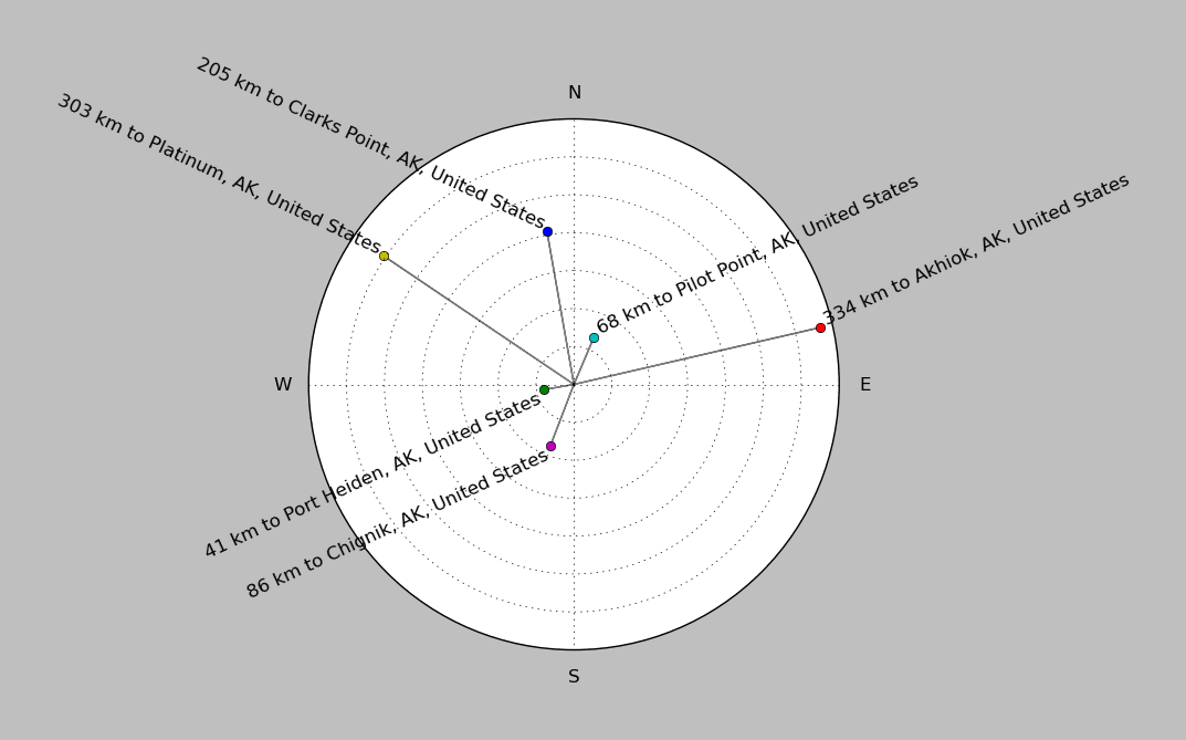
| ||||||||||||||||
Event and active stations
|
|||||||||||||||||
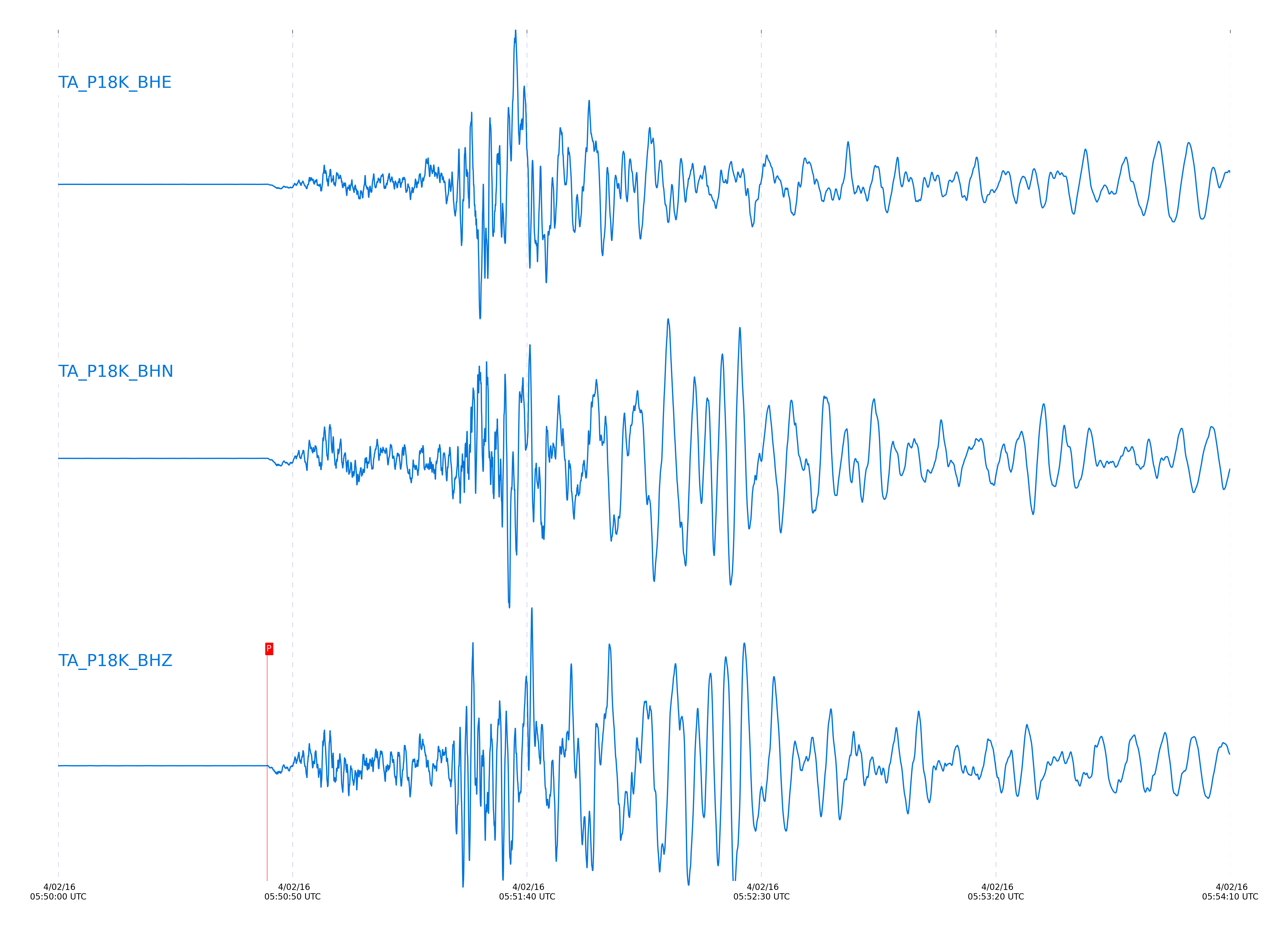
Seismic waveforms for closest station
Closest station with identified signal. Not filtered.
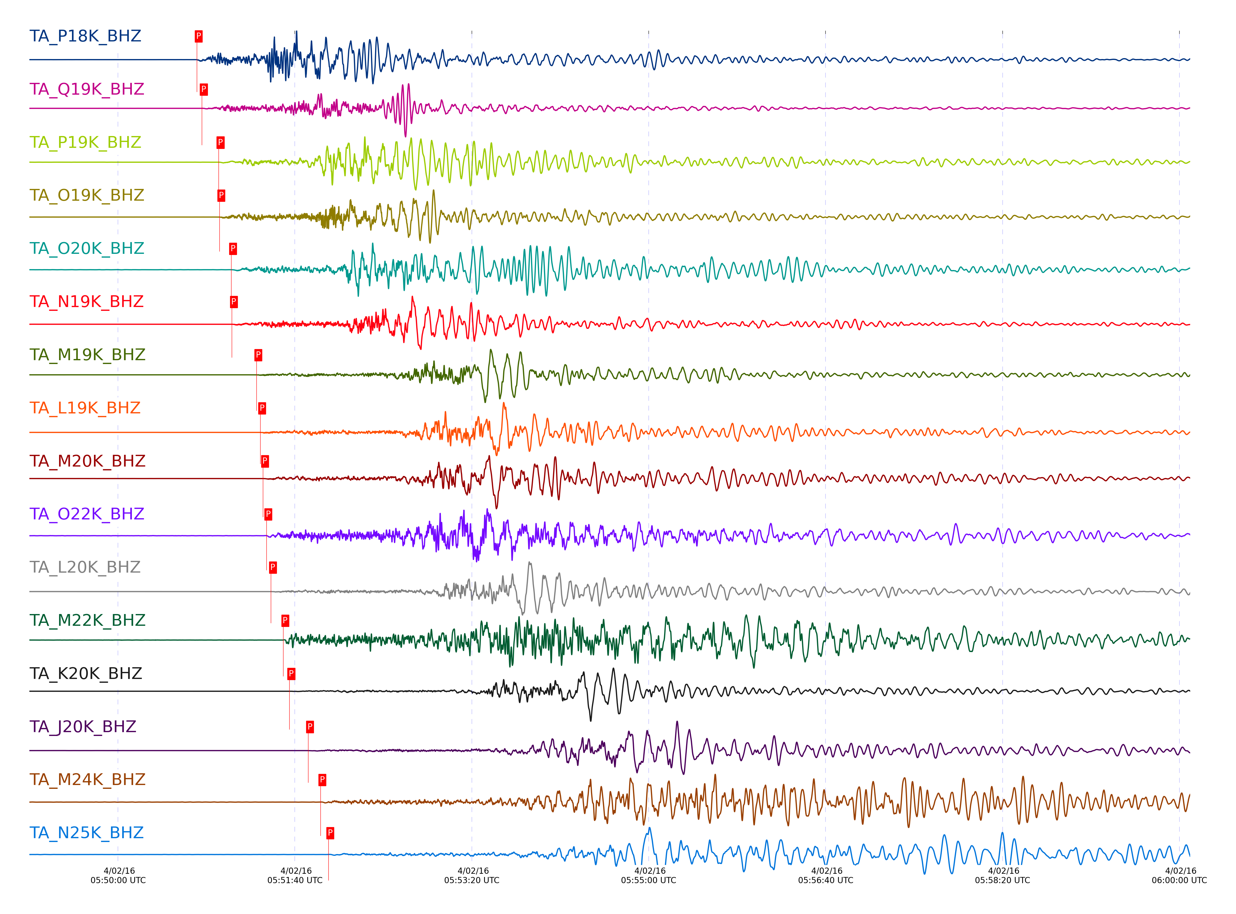
Seismic waveforms for vertical channels in network
Subset of several stations close to the event. Not filtered.
Signal description at some stations
| STA_CHAN | S-E Delta | S-E Azimuth | Phase | Time | Signal/Noise | Time Residual | V. Model | Auth | arid |
|---|---|---|---|---|---|---|---|---|---|
| P18K_BHZ | 2.752° | 211.84° | Pn | 2016-04-02 05:50:44.5897 UTC | -1 | 1.369 | iasp91 | dbp:jtytell:160 | 2883429 |
| Q19K_BHZ | 2.95° | 231.65° | Pn | 2016-04-02 05:50:47.4543 UTC | 66.106 | 1.517 | iasp91 | dbp:jtytell:160 | 2880049 |
| P19K_BHZ | 3.589° | 224.99° | pPn | 2016-04-02 05:50:56.9051 UTC | -1 | -2.125 | iasp91 | dbp:jtytell:160 | 2883430 |
| O19K_BHZ | 3.675° | 211.98° | Pn | 2016-04-02 05:50:57.3875 UTC | 474.68 | 1.47 | iasp91 | dbp:jtytell:160 | 2880054 |
| O20K_BHZ | 4.109° | 224.26° | Pn | 2016-04-02 05:51:04.0113 UTC | 46.494 | 2.13 | iasp91 | dbp:jtytell:160 | 2880052 |
| N19K_BHZ | 4.176° | 206.42° | Pn | 2016-04-02 05:51:04.4107 UTC | 282.84 | 1.61 | iasp91 | dbp:jtytell:160 | 2880051 |
| M19K_BHZ | 5.191° | 201.58° | Pn | 2016-04-02 05:51:18.3056 UTC | -1 | 1.553 | iasp91 | dbp:jtytell:160 | 2883431 |
| L19K_BHZ | 5.379° | 197.94° | Pn | 2016-04-02 05:51:20.4228 UTC | 474.19 | 1.083 | iasp91 | dbp:jtytell:160 | 2880056 |
| M20K_BHZ | 5.424° | 208.57° | Pn | 2016-04-02 05:51:22.0199 UTC | 459.83 | 2.073 | iasp91 | dbp:jtytell:160 | 2880058 |
| O22K_BHZ | 5.463° | 234.36° | pPn | 2016-04-02 05:51:23.9341 UTC | 43.575 | -0.848 | iasp91 | dbp:jtytell:160 | 2880060 |
| L20K_BHZ | 5.814° | 202.11° | Pn | 2016-04-02 05:51:26.497 UTC | 482.79 | 1.191 | iasp91 | dbp:jtytell:160 | 2880061 |
| M22K_BHZ | 6.158° | 223.35° | pPn | 2016-04-02 05:51:33.4679 UTC | 458.99 | -0.871 | iasp91 | dbp:jtytell:160 | 2880065 |
| K20K_BHZ | 6.608° | 198.4° | Pn | 2016-04-02 05:51:36.9265 UTC | 90.548 | 0.711 | iasp91 | dbp:jtytell:160 | 2880067 |
| J20K_BHZ | 7.381° | 196.09° | Pn | 2016-04-02 05:51:47.5219 UTC | 55.304 | 0.694 | iasp91 | dbp:jtytell:160 | 2880074 |
| M24K_BHZ | 7.795° | 234.61° | Pn | 2016-04-02 05:51:54.4619 UTC | 82.276 | 1.959 | iasp91 | dbp:jtytell:160 | 2880084 |
| N25K_BHZ | 8.164° | 241.84° | Pn | 2016-04-02 05:51:58.9858 UTC | 24.109 | 1.417 | iasp91 | dbp:jtytell:160 | 2880087 |
| HARP_BHZ | 8.351° | 235.73° | pPn | 2016-04-02 05:52:03.5793 UTC | 42.837 | -0.856 | iasp91 | dbp:jtytell:160 | 2880089 |
| I21K_BHZ | 8.632° | 201.94° | Pn | 2016-04-02 05:52:05.9876 UTC | 97.075 | 2 | iasp91 | dbp:jtytell:160 | 2880091 |
| H21K_BHZ | 8.963° | 198.06° | Pn | 2016-04-02 05:52:09.3316 UTC | 601.05 | 0.8 | iasp91 | dbp:jtytell:160 | 2880095 |
| I23K_BHZ | 9.092° | 210.75° | pPn | 2016-04-02 05:52:12.5557 UTC | 269.49 | -2.056 | iasp91 | dbp:jtytell:160 | 2880098 |
| TCOL_BHZ | 9.214° | 216.32° | pPn | 2016-04-02 05:52:14.6155 UTC | 131.08 | -1.656 | iasp91 | dbp:jtytell:160 | 2880102 |
| L26K_BHZ | 9.388° | 236.95° | pPn | 2016-04-02 05:52:17.6418 UTC | 47.345 | -1.024 | iasp91 | dbp:jtytell:160 | 2880106 |
| POKR_BHZ | 9.517° | 216.71° | pPn | 2016-04-02 05:52:18.5481 UTC | 202.65 | -1.884 | iasp91 | dbp:jtytell:160 | 2880108 |
| M27K_BHZ | 9.644° | 243.7° | pPn | 2016-04-02 05:52:20.2129 UTC | 41.39 | -1.958 | iasp91 | dbp:jtytell:160 | 2880112 |
| J25K_BHZ | 9.705° | 224.45° | pPn | 2016-04-02 05:52:21.3708 UTC | 172.35 | -1.634 | iasp91 | dbp:jtytell:160 | 2880116 |
| L27K_BHZ | 9.995° | 240.22° | Pn | 2016-04-02 05:52:24.77 UTC | 98.267 | 2.094 | iasp91 | dbp:jtytell:160 | 2880120 |
| H24K_BHZ | 10.002° | 213.03° | pPn | 2016-04-02 05:52:25.5604 UTC | 255.78 | -1.524 | iasp91 | dbp:jtytell:160 | 2880124 |
| J26L_BHZ | 10.196° | 229.56° | pPn | 2016-04-02 05:52:28.2223 UTC | 136.11 | -1.518 | iasp91 | dbp:jtytell:160 | 2880128 |
| M30M_BHZ | 11.903° | 251.83° | pPn | 2016-04-02 05:52:51.4138 UTC | 57.693 | -1.686 | iasp91 | dbp:jtytell:160 | 2880142 |
| N31M_BHZ | 12.081° | 258.26° | pPn | 2016-04-02 05:52:53.8528 UTC | 47.333 | -1.686 | iasp91 | dbp:jtytell:160 | 2880144 |
| TOLK_BHZ | 12.195° | 201.9° | pPn | 2016-04-02 05:52:55.3348 UTC | 181.93 | -1.768 | iasp91 | dbp:jtytell:160 | 2880146 |
| I29M_BHZ | 12.498° | 237.48° | pPn | 2016-04-02 05:52:59.0885 UTC | 41.008 | -2.158 | iasp91 | dbp:jtytell:160 | 2880150 |
| M31M_BHZ | 12.875° | 256.96° | pPn | 2016-04-02 05:53:05.0984 UTC | 37.407 | -1.294 | iasp91 | dbp:jtytell:160 | 2880152 |
| P33M_BHZ | 13.354° | 267.26° | pPn | 2016-04-02 05:53:11.3215 UTC | 33.525 | -1.612 | iasp91 | dbp:jtytell:160 | 2880154 |
| EPYK_BHZ | 13.591° | 236.79° | Pn | 2016-04-02 05:53:13.7653 UTC | 169.73 | 1.915 | iasp91 | dbp:jtytell:160 | 2880156 |
| A21K_BHZ | 14.307° | 182.82° | Pn | 2016-04-02 05:53:22.8604 UTC | 81.834 | 0.989 | iasp91 | dbp:jtytell:160 | 2880158 |
| C36M_BHZ | 19.184° | 247.23° | P | 2016-04-02 05:54:21.411 UTC | 76.386 | -1.232 | iasp91 | dbp:jtytell:160 | 2880164 |
| A36M_BHZ | 20.031° | 239.01° | P | 2016-04-02 05:54:30.7706 UTC | 212.85 | -1.132 | iasp91 | dbp:jtytell:160 | 2880166 |
| A04D_BHZ | 22.499° | 304.95° | pP | 2016-04-02 05:55:02.853 UTC | 26.227 | -0.738 | iasp91 | dbp:jtytell:160 | 2880168 |
| D03D_BHZ | 22.991° | 307.31° | pP | 2016-04-02 05:55:08.3612 UTC | 43.697 | -0.459 | iasp91 | dbp:jtytell:160 | 2880170 |
| B05D_BHZ | 23.092° | 305.73° | pP | 2016-04-02 05:55:09.0657 UTC | 79.967 | -0.825 | iasp91 | dbp:jtytell:160 | 2880172 |
| D04E_BHZ | 23.379° | 307.89° | pP | 2016-04-02 05:55:12.9006 UTC | 14.162 | -0.016 | iasp91 | dbp:jtytell:160 | 2880174 |
| E04D_BHZ | 23.875° | 308.96° | pP | 2016-04-02 05:55:17.3606 UTC | 73.612 | -0.517 | iasp91 | dbp:jtytell:160 | 2880176 |
| F04D_BHZ | 23.939° | 309.9° | pP | 2016-04-02 05:55:17.5979 UTC | 5.6204 | -0.867 | iasp91 | dbp:jtytell:160 | 2880178 |
| C06D_BHZ | 23.942° | 306.18° | pP | 2016-04-02 05:55:17.2513 UTC | -1 | -1.243 | iasp91 | dbp:jtytell:160 | 2883441 |
| G03D_BHZ | 24.373° | 311.45° | pP | 2016-04-02 05:55:21.6261 UTC | 9.7608 | -0.801 | iasp91 | dbp:jtytell:160 | 2880180 |
| I02E_BHZ | 24.812° | 313.43° | pP | 2016-04-02 05:55:26.0504 UTC | -1 | -0.379 | iasp91 | dbp:jtytell:160 | 2883442 |
| F05D_BHZ | 24.893° | 309.83° | pP | 2016-04-02 05:55:26.2011 UTC | 18.877 | -0.97 | iasp91 | dbp:jtytell:160 | 2880182 |
| H04D_BHZ | 25.11° | 312.39° | pP | 2016-04-02 05:55:28.4677 UTC | 44.797 | -0.679 | iasp91 | dbp:jtytell:160 | 2880184 |
| I03D_BHZ | 25.355° | 313.88° | pP | 2016-04-02 05:55:30.4823 UTC | 33.73 | -0.89 | iasp91 | dbp:jtytell:160 | 2880189 |
| G05D_BHZ | 25.386° | 310.84° | pP | 2016-04-02 05:55:30.5992 UTC | 39.664 | -1.052 | iasp91 | dbp:jtytell:160 | 2880187 |
| J01E_BHZ | 25.427° | 314.91° | pP | 2016-04-02 05:55:31.711 UTC | 34.616 | -0.32 | iasp91 | dbp:jtytell:160 | 2880191 |
| I04A_BHZ | 25.778° | 313.41° | pP | 2016-04-02 05:55:34.3766 UTC | 85.673 | -0.838 | iasp91 | dbp:jtytell:160 | 2880195 |
| K02D_BHZ | 25.895° | 315.49° | pP | 2016-04-02 05:55:35.802 UTC | 49.746 | -0.475 | iasp91 | dbp:jtytell:160 | 2880199 |
| I05D_BHZ | 25.973° | 312.25° | pP | 2016-04-02 05:55:36.1266 UTC | 55.506 | -0.853 | iasp91 | dbp:jtytell:160 | 2880197 |
| L02E_BHZ | 26.313° | 316.23° | pP | 2016-04-02 05:55:39.5026 UTC | 22.539 | -0.558 | iasp91 | dbp:jtytell:160 | 2880201 |
| J04D_BHZ | 26.319° | 314.12° | pP | 2016-04-02 05:55:39.8972 UTC | 54.148 | -0.219 | iasp91 | dbp:jtytell:160 | 2880203 |
| J05D_BHZ | 26.747° | 313.77° | pP | 2016-04-02 05:55:43.688 UTC | 132.67 | -0.293 | iasp91 | dbp:jtytell:160 | 2880205 |
| K04D_BHZ | 26.937° | 314.88° | pP | 2016-04-02 05:55:45.1389 UTC | 19.254 | -0.552 | iasp91 | dbp:jtytell:160 | 2880209 |
| L04D_BHZ | 26.939° | 315.64° | P | 2016-04-02 05:55:44.9605 UTC | 49.812 | 0.744 | iasp91 | dbp:jtytell:160 | 2880207 |
| M02C_BHZ | 27.254° | 316.97° | pP | 2016-04-02 05:55:48.5 UTC | 36.563 | -0.042 | iasp91 | dbp:jtytell:160 | 2880211 |
| M04C_BHZ | 27.492° | 316.06° | pP | 2016-04-02 05:55:50.4213 UTC | 75.412 | -0.266 | iasp91 | dbp:jtytell:160 | 2880213 |
| N02D_BHZ | 27.636° | 317.45° | pP | 2016-04-02 05:55:51.8174 UTC | 55.03 | -0.161 | iasp91 | dbp:jtytell:160 | 2880215 |
| O02D_BHZ | 28.186° | 318.49° | pP | 2016-04-02 05:55:56.3611 UTC | 33.865 | -0.535 | iasp91 | dbp:jtytell:160 | 2880348 |
| O03E_BHZ | 28.6° | 317.95° | pP | 2016-04-02 05:55:59.2101 UTC | 82.612 | -1.375 | iasp91 | dbp:jtytell:160 | 2880219 |
| H17A_BHZ | 31.73° | 310.46° | pP | 2016-04-02 05:56:28.4651 UTC | 74.277 | 0.201 | iasp91 | dbp:jtytell:160 | 2880227 |
| R11A_BHZ | 33.264° | 318.09° | pP | 2016-04-02 05:56:40.5775 UTC | 199.25 | -1.114 | iasp91 | dbp:jtytell:160 | 2880239 |
| K22A_BHZ | 35.087° | 312.29° | pP | 2016-04-02 05:56:55.3156 UTC | 35.16 | -2.17 | iasp91 | dbp:jtytell:160 | 2880263 |
| MDND_BHZ | 35.52° | 307.16° | pP | 2016-04-02 05:56:59.413 UTC | 37.328 | -1.8 | iasp91 | dbp:jtytell:160 | 2880269 |
| O20A_BHZ | 35.891° | 314.96° | pP | 2016-04-02 05:57:02.6759 UTC | 102.66 | -1.715 | iasp91 | dbp:jtytell:160 | 2880275 |
| TPFO_BHZ | 36.474° | 322.7° | pP | 2016-04-02 05:57:07.8054 UTC | 57.534 | -1.575 | iasp91 | dbp:jtytell:160 | 2880289 |
| N23A_BHZ | 36.604° | 314.04° | pP | 2016-04-02 05:57:08.8417 UTC | 51.75 | -1.647 | iasp91 | dbp:jtytell:160 | 2880293 |
| 109C_BHZ | 36.721° | 323.51° | pP | 2016-04-02 05:57:10.1154 UTC | 23.197 | -1.37 | iasp91 | dbp:jtytell:160 | 2880297 |
| SUSD_BHZ | 38.012° | 310.79° | pP | 2016-04-02 05:57:20.0218 UTC | 18.264 | -2.411 | iasp91 | dbp:jtytell:160 | 2880309 |
| S22A_BHZ | 38.372° | 317° | pP | 2016-04-02 05:57:24.4431 UTC | 36.124 | -1.022 | iasp91 | dbp:jtytell:160 | 2880361 |
| Q24A_BHZ | 38.399° | 315.78° | pP | 2016-04-02 05:57:24.3983 UTC | 14.181 | -1.295 | iasp91 | dbp:jtytell:160 | 2880362 |
| W18A_BHZ | 38.78° | 319.65° | pP | 2016-04-02 05:57:27.508 UTC | 13.188 | -1.387 | iasp91 | dbp:jtytell:160 | 2880365 |
| 214A_BHZ | 39.641° | 322.83° | pP | 2016-04-02 05:57:34.5403 UTC | 69.466 | -1.557 | iasp91 | dbp:jtytell:160 | 2880371 |
| KSCO_BHZ | 39.735° | 315.59° | pP | 2016-04-02 05:57:35.258 UTC | 36.648 | -1.619 | iasp91 | dbp:jtytell:160 | 2880374 |
| T25A_BHZ | 40.123° | 317.25° | pP | 2016-04-02 05:57:38.7985 UTC | 42.493 | -1.31 | iasp91 | dbp:jtytell:160 | 2880375 |
| BGNE_BHZ | 40.488° | 313.61° | pP | 2016-04-02 05:57:40.8866 UTC | 21.855 | -2.244 | iasp91 | dbp:jtytell:160 | 2880377 |
| SPMN_BHZ | 40.803° | 310.94° | pP | 2016-04-02 05:57:43.4539 UTC | 103.85 | -2.276 | iasp91 | dbp:jtytell:160 | 2880379 |
| 121A_BHZ | 41.805° | 321.21° | pP | 2016-04-02 05:57:52.7782 UTC | 49.053 | -1.196 | iasp91 | dbp:jtytell:160 | 2880383 |
| MSTX_BHZ | 43.378° | 319.45° | pP | 2016-04-02 05:58:04.2778 UTC | 30.462 | -2.486 | iasp91 | dbp:jtytell:160 | 2880387 |
| L44A_BHZ | 45.466° | 314.16° | P | 2016-04-02 05:58:20.1307 UTC | 12.83 | 2.261 | iasp91 | dbp:jtytell:160 | 2880393 |
| TUL1_BHZ | 45.711° | 317.78° | P | 2016-04-02 05:58:22.2963 UTC | 26.206 | 2.492 | iasp91 | dbp:jtytell:160 | 2880397 |
| ABTX_BHZ | 46.095° | 320.03° | pP | 2016-04-02 05:58:25.8048 UTC | 74.089 | -2.655 | iasp91 | dbp:jtytell:160 | 2880401 |
| U40A_BHZ | 46.98° | 317.55° | P | 2016-04-02 05:58:31.125 UTC | 29.123 | 1.346 | iasp91 | dbp:jtytell:160 | 2880402 |
| SFIN_BHZ | 47.169° | 315.5° | P | 2016-04-02 05:58:33.8904 UTC | 56.839 | 2.632 | iasp91 | dbp:jtytell:160 | 2880405 |
| W39A_BHZ | 47.335° | 318.25° | P | 2016-04-02 05:58:34.7255 UTC | 44.816 | 2.179 | iasp91 | dbp:jtytell:160 | 2880406 |
| WHTX_BHZ | 47.765° | 320.25° | pP | 2016-04-02 05:58:38.9137 UTC | 14.657 | -2.622 | iasp91 | dbp:jtytell:160 | 2880413 |
| W41B_BHZ | 48.187° | 318.3° | P | 2016-04-02 05:58:40.682 UTC | 16.681 | 1.521 | iasp91 | dbp:jtytell:160 | 2880414 |
| O48B_BHZ | 48.291° | 315.87° | P | 2016-04-02 05:58:41.5622 UTC | 60.623 | 1.601 | iasp91 | dbp:jtytell:160 | 2880416 |
| X40A_BHZ | 48.382° | 318.69° | P | 2016-04-02 05:58:42.3943 UTC | 18.029 | 1.728 | iasp91 | dbp:jtytell:160 | 2880418 |
| 435B_BHZ | 48.629° | 320.95° | pP | 2016-04-02 05:58:45.8832 UTC | -1 | -2.339 | iasp91 | dbp:jtytell:160 | 2883453 |
| P49A_BHZ | 49.045° | 316.38° | P | 2016-04-02 05:58:47.3983 UTC | 43.019 | 1.632 | iasp91 | dbp:jtytell:160 | 2880421 |
| Z41A_BHZ | 49.328° | 319.39° | P | 2016-04-02 05:58:50.5744 UTC | 13.534 | 2.646 | iasp91 | dbp:jtytell:160 | 2880422 |
| 833A_BHZ | 49.584° | 322.44° | pP | 2016-04-02 05:58:52.9698 UTC | 20.701 | -2.575 | iasp91 | dbp:jtytell:160 | 2880427 |
| M53A_BHZ | 49.8° | 315.98° | P | 2016-04-02 05:58:54.3388 UTC | 35.595 | 2.807 | iasp91 | dbp:jtytell:160 | 2880432 |
| M54A_BHZ | 50.276° | 316.15° | P | 2016-04-02 05:58:57.7805 UTC | 69.007 | 2.635 | iasp91 | dbp:jtytell:160 | 2880436 |
| P52A_BHZ | 50.342° | 316.74° | P | 2016-04-02 05:58:57.2401 UTC | 23.619 | 1.591 | iasp91 | dbp:jtytell:160 | 2880434 |
| O53A_BHZ | 50.378° | 316.56° | P | 2016-04-02 05:58:57.9834 UTC | 36.655 | 2.059 | iasp91 | dbp:jtytell:160 | 2880438 |
| N54A_BHZ | 50.502° | 316.4° | P | 2016-04-02 05:58:59.3288 UTC | 36.239 | 2.472 | iasp91 | dbp:jtytell:160 | 2880440 |
| O56A_BHZ | 51.747° | 317.07° | P | 2016-04-02 05:59:08.5858 UTC | 36.809 | 2.37 | iasp91 | dbp:jtytell:160 | 2880446 |
| N59A_BHZ | 52.714° | 317.34° | pP | 2016-04-02 05:59:16.4774 UTC | 47.589 | -2.619 | iasp91 | dbp:jtytell:160 | 2880456 |
| L61B_BHZ | 53.151° | 317.33° | P | 2016-04-02 05:59:19.4051 UTC | 8.5346 | 2.772 | iasp91 | dbp:jtytell:160 | 2880462 |
| KMSC_BHZ | 54.105° | 319.2° | P | 2016-04-02 05:59:25.7039 UTC | 26.78 | 2.072 | iasp91 | dbp:jtytell:160 | 2880473 |
| TIGA_BHZ | 55.724° | 320.65° | P | 2016-04-02 05:59:36.1769 UTC | -1 | 0.816 | iasp91 | dbp:jtytell:160 | 2883456 |
External resources
Current seismic activity measured by the seismic network
Click the link below to observe an interactive map of earthquakes recorded by the station deployment: