last update to page: March 31 2016 18:30:39 (UTC).
Magnitude 6.4 Earthquake: Near East Coast Of Kamchatka
SummaryThe red marker denotes the earthquake epicenter. On Sun Mar 20th 2016 22:50:20 (UTC) the seismic network recorded an earthquake (preliminary 6.4 mwc) located in Near East Coast Of Kamchatka. Seismic region Japan - Kuriles - Kamchatka. The epicentral distance (i.e. distance separating the location to the epicenter) to the closest station N18K in the network is 2,522.4 km. If you felt the quake, the USGS would like to know. Please add your comments to the USGS page "Did you feel it?". |
Details
Proximity to Population Centers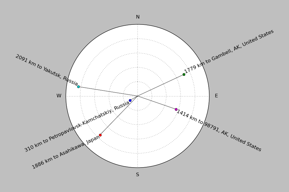
| ||||||||||||||||
Event and active stations
|
|||||||||||||||||
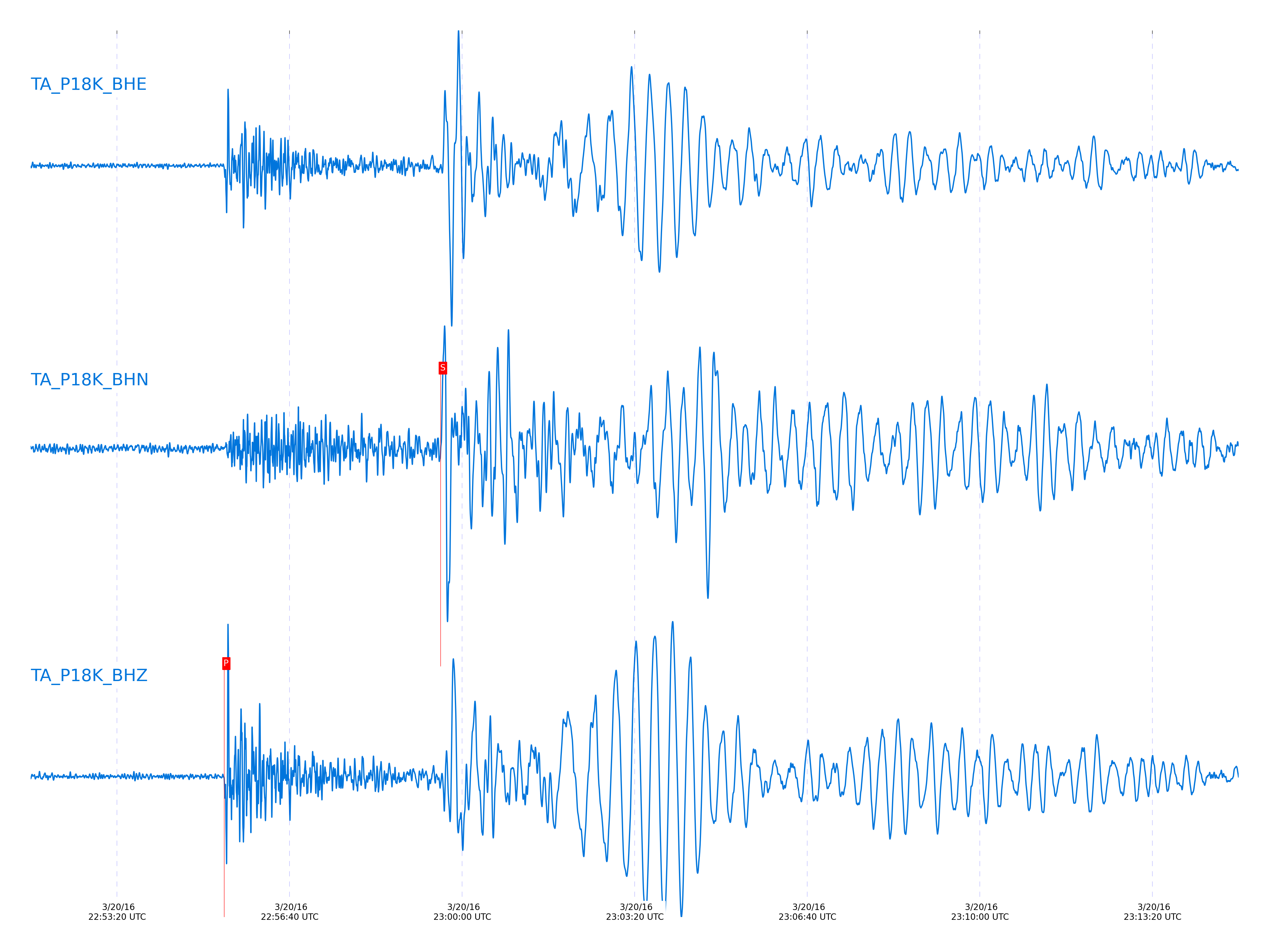
Seismic waveforms for closest station
Closest station with identified signal. Not filtered.
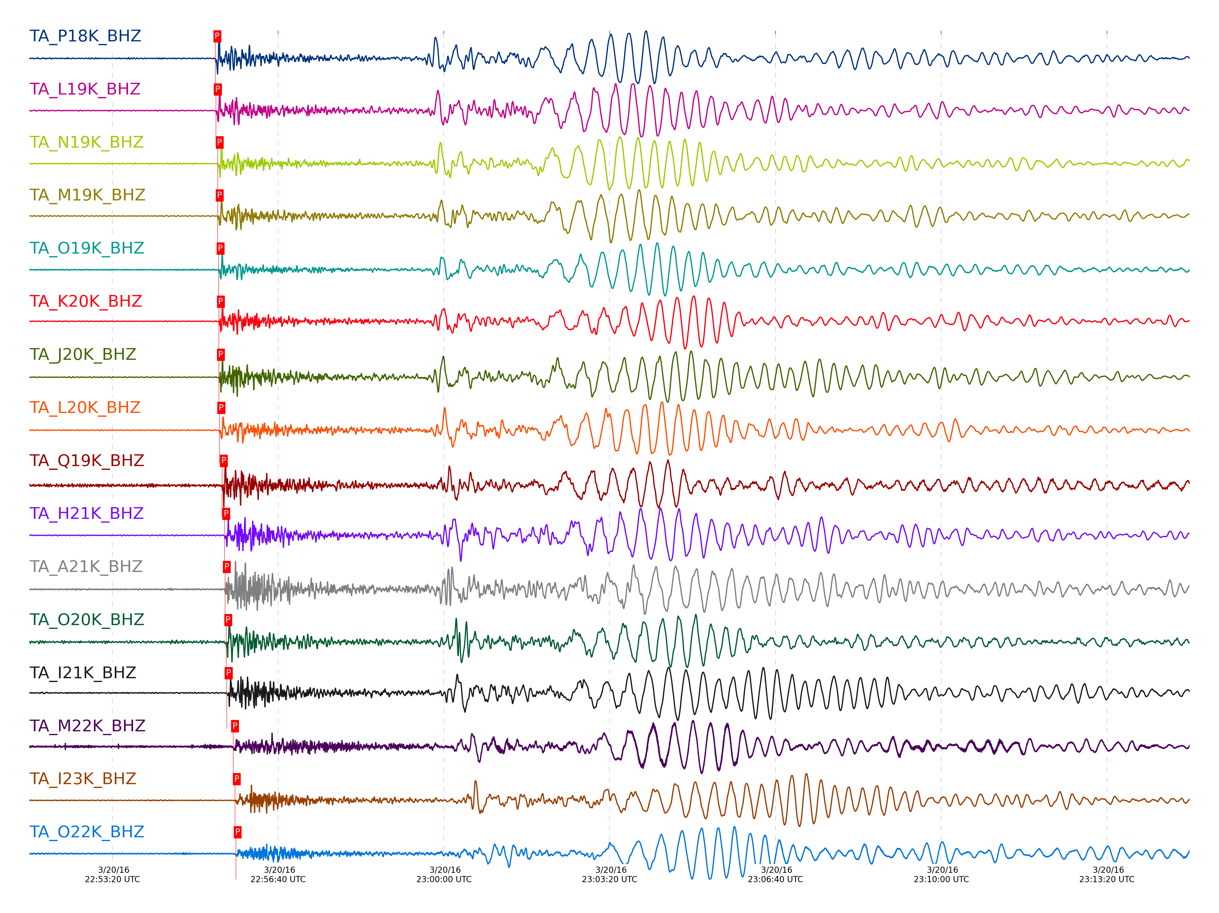
Seismic waveforms for vertical channels in network
Subset of several stations close to the event. Not filtered.
Signal description at some stations
| STA_CHAN | S-E Delta | S-E Azimuth | Phase | Time | Signal/Noise | Time Residual | V. Model | Auth | arid |
|---|---|---|---|---|---|---|---|---|---|
| P18K_BHZ | 23.082° | 275.94° | P | 2016-03-20 22:55:24.2645 UTC | -1 | 0.132 | iasp91 | dbp:mcwhite:160 | 2866589 |
| L19K_BHZ | 23.127° | 269.71° | P | 2016-03-20 22:55:24.9377 UTC | 118.18 | 0.388 | iasp91 | dbp:mcwhite:160 | 2864254 |
| N19K_BHZ | 23.339° | 273.21° | P | 2016-03-20 22:55:27.2296 UTC | 213.94 | 0.741 | iasp91 | dbp:mcwhite:160 | 2864255 |
| M19K_BHZ | 23.346° | 270.76° | P | 2016-03-20 22:55:27.1953 UTC | -1 | 0.648 | iasp91 | dbp:mcwhite:160 | 2866590 |
| O19K_BHZ | 23.463° | 274.76° | P | 2016-03-20 22:55:28.2072 UTC | 88.017 | 0.524 | iasp91 | dbp:mcwhite:160 | 2864256 |
| K20K_BHZ | 23.513° | 267.7° | P | 2016-03-20 22:55:28.619 UTC | 415.66 | 0.406 | iasp91 | dbp:mcwhite:160 | 2864258 |
| J20K_BHZ | 23.526° | 265.74° | P | 2016-03-20 22:55:28.6028 UTC | 811.44 | 0.254 | iasp91 | dbp:mcwhite:160 | 2864257 |
| L20K_BHZ | 23.581° | 269.89° | P | 2016-03-20 22:55:29.1324 UTC | 79.205 | 0.207 | iasp91 | dbp:mcwhite:160 | 2864260 |
| Q19K_BHZ | 23.945° | 278.13° | P | 2016-03-20 22:55:32.2681 UTC | -1 | 0.241 | iasp91 | dbp:mcwhite:160 | 2866591 |
| H21K_BHZ | 24.228° | 263.75° | P | 2016-03-20 22:55:35.125 UTC | 561.76 | 0.51 | iasp91 | dbp:mcwhite:160 | 2864262 |
| A21K_BHZ | 24.295° | 247.22° | P | 2016-03-20 22:55:35.7705 UTC | 44.333 | 0.55 | iasp91 | dbp:mcwhite:160 | 2864265 |
| O20K_BHZ | 24.314° | 276.31° | P | 2016-03-20 22:55:37.425 UTC | 53.112 | 0.869 | iasp91 | dbp:mcwhite:160 | 2864267 |
| I21K_BHZ | 24.525° | 265.61° | P | 2016-03-20 22:55:37.997 UTC | 260.04 | 0.678 | iasp91 | dbp:mcwhite:160 | 2864546 |
| M22K_BHZ | 25.366° | 274.65° | P | 2016-03-20 22:55:45.684 UTC | -1 | 0.711 | iasp91 | dbp:mcwhite:160 | 2866594 |
| I23K_BHZ | 25.623° | 268.19° | P | 2016-03-20 22:55:47.841 UTC | 110.32 | 0.543 | iasp91 | dbp:mcwhite:160 | 2864276 |
| O22K_BHZ | 25.693° | 277.6° | P | 2016-03-20 22:55:48.96 UTC | 25.941 | 1.029 | iasp91 | dbp:mcwhite:160 | 2864698 |
| TOLK_BHZ | 25.877° | 260.76° | P | 2016-03-20 22:55:50.1566 UTC | 361.06 | 0.557 | iasp91 | dbp:mcwhite:160 | 2864286 |
| TCOL_BHZ | 26.252° | 270.13° | P | 2016-03-20 22:55:53.5382 UTC | 47.545 | 0.548 | iasp91 | dbp:mcwhite:160 | 2864301 |
| H24K_BHZ | 26.259° | 268.16° | P | 2016-03-20 22:55:53.8334 UTC | 109.65 | 0.774 | iasp91 | dbp:mcwhite:160 | 2864295 |
| POKR_BHZ | 26.432° | 270.02° | P | 2016-03-20 22:55:55.4667 UTC | 124.67 | 0.844 | iasp91 | dbp:mcwhite:160 | 2864303 |
| M24K_BHZ | 27.177° | 277.03° | P | 2016-03-20 22:56:02.1534 UTC | 102.23 | 0.825 | iasp91 | dbp:mcwhite:160 | 2864311 |
| J25K_BHZ | 27.321° | 272.84° | P | 2016-03-20 22:56:01.7364 UTC | -1 | -0.885 | iasp91 | dbp:mcwhite:160 | 2866597 |
| Q23K_BHZ | 27.541° | 282.02° | P | 2016-03-20 22:56:06.5319 UTC | 5.3196 | 1.94 | iasp91 | dbp:mcwhite:160 | 2864326 |
| HARP_BHZ | 27.611° | 277.26° | P | 2016-03-20 22:56:04.9607 UTC | 23.705 | -0.257 | iasp91 | dbp:mcwhite:160 | 2864320 |
| N25K_BHZ | 27.984° | 279.17° | P | 2016-03-20 22:56:09.1408 UTC | 22.747 | 0.592 | iasp91 | dbp:mcwhite:160 | 2864330 |
| J26L_BHZ | 28.103° | 274.59° | P | 2016-03-20 22:56:10. UTC | 40.923 | 0.392 | iasp91 | dbp:mcwhite:160 | 2864328 |
| L27K_BHZ | 29.031° | 278.61° | P | 2016-03-20 22:56:19.0923 UTC | 348.15 | 1.231 | iasp91 | dbp:mcwhite:160 | 2864336 |
| M27K_BHZ | 29.12° | 279.82° | P | 2016-03-20 22:56:20.0788 UTC | 83.005 | 1.419 | iasp91 | dbp:mcwhite:160 | 2864338 |
| I29M_BHZ | 30.228° | 277.41° | P | 2016-03-20 22:56:29.0146 UTC | 15.697 | 0.549 | iasp91 | dbp:mcwhite:160 | 2864346 |
| J29M_BHZ | 30.396° | 279.02° | P | 2016-03-20 22:56:30.0649 UTC | -1 | 0.119 | iasp91 | dbp:mcwhite:160 | 2866600 |
| M30M_BHZ | 31.38° | 283.16° | P | 2016-03-20 22:56:40.2056 UTC | 83.297 | 1.594 | iasp91 | dbp:mcwhite:160 | 2864352 |
| N31M_BHZ | 32.111° | 285.58° | P | 2016-03-20 22:56:46.7428 UTC | 34.162 | 1.715 | iasp91 | dbp:mcwhite:160 | 2864549 |
| M31M_BHZ | 32.551° | 285.43° | P | 2016-03-20 22:56:50.825 UTC | 139.87 | 1.946 | iasp91 | dbp:mcwhite:160 | 2864550 |
| P33M_BHZ | 33.87° | 289.37° | P | 2016-03-20 22:57:01.9637 UTC | 106.06 | 1.606 | iasp91 | dbp:mcwhite:160 | 2864554 |
| A36M_BHZ | 34.06° | 278.16° | P | 2016-03-20 22:57:03.1325 UTC | 184.7 | 1.129 | iasp91 | dbp:mcwhite:160 | 2864556 |
| A04D_BHZ | 44.491° | 306.7° | P | 2016-03-20 22:58:31.3622 UTC | 8.3875 | 2.399 | iasp91 | dbp:mcwhite:160 | 2864561 |
| D03D_BHZ | 45.002° | 307.53° | P | 2016-03-20 22:58:34.7328 UTC | 39.343 | 1.694 | iasp91 | dbp:mcwhite:160 | 2864562 |
| B05D_BHZ | 45.088° | 307.28° | P | 2016-03-20 22:58:35.1705 UTC | 27.55 | 1.448 | iasp91 | dbp:mcwhite:160 | 2864563 |
| D04E_BHZ | 45.391° | 307.91° | P | 2016-03-20 22:58:38.8868 UTC | 19.106 | 2.767 | iasp91 | dbp:mcwhite:160 | 2864564 |
| E04D_BHZ | 45.885° | 308.45° | P | 2016-03-20 22:58:42.3216 UTC | 37.218 | 2.294 | iasp91 | dbp:mcwhite:160 | 2864566 |
| C06D_BHZ | 45.932° | 307.96° | P | 2016-03-20 22:58:43.1591 UTC | 8.6754 | 2.756 | iasp91 | dbp:mcwhite:160 | 2864565 |
| F04D_BHZ | 45.941° | 308.68° | P | 2016-03-20 22:58:43.1233 UTC | 6.8168 | 2.656 | iasp91 | dbp:mcwhite:160 | 2864567 |
| G03D_BHZ | 46.351° | 309.25° | P | 2016-03-20 22:58:45.5255 UTC | 6.1167 | 1.829 | iasp91 | dbp:mcwhite:160 | 2864568 |
| I02E_BHZ | 46.734° | 309.9° | P | 2016-03-20 22:58:49.6128 UTC | -1 | 2.909 | iasp91 | dbp:mcwhite:160 | 2866602 |
| F05D_BHZ | 46.903° | 309.29° | P | 2016-03-20 22:58:49.8399 UTC | 7.0234 | 1.819 | iasp91 | dbp:mcwhite:160 | 2864569 |
| H04D_BHZ | 47.077° | 309.9° | P | 2016-03-20 22:58:51.45 UTC | 12.545 | 2.07 | iasp91 | dbp:mcwhite:160 | 2864570 |
| I03D_BHZ | 47.274° | 310.32° | P | 2016-03-20 22:58:52.9912 UTC | 5.7043 | 2.077 | iasp91 | dbp:mcwhite:160 | 2864571 |
| J01E_BHZ | 47.299° | 310.55° | P | 2016-03-20 22:58:53.551 UTC | -1 | 2.439 | iasp91 | dbp:mcwhite:160 | 2866603 |
| G05D_BHZ | 47.389° | 309.8° | P | 2016-03-20 22:58:53.8762 UTC | 16.291 | 2.061 | iasp91 | dbp:mcwhite:160 | 2864573 |
| I04A_BHZ | 47.727° | 310.5° | P | 2016-03-20 22:58:56.2694 UTC | -1 | 1.835 | iasp91 | dbp:mcwhite:160 | 2866604 |
| K02D_BHZ | 47.751° | 310.94° | P | 2016-03-20 22:58:56.9444 UTC | -1 | 2.322 | iasp91 | dbp:mcwhite:160 | 2866605 |
| I05D_BHZ | 47.959° | 310.42° | P | 2016-03-20 22:58:58.0655 UTC | 15.23 | 1.828 | iasp91 | dbp:mcwhite:160 | 2864574 |
| L02E_BHZ | 48.139° | 311.32° | P | 2016-03-20 22:59:00.6675 UTC | 7.1467 | 3.039 | iasp91 | dbp:mcwhite:160 | 2864576 |
| J04D_BHZ | 48.254° | 310.96° | P | 2016-03-20 22:59:00.2321 UTC | 21.173 | 1.718 | iasp91 | dbp:mcwhite:160 | 2864575 |
| J05D_BHZ | 48.705° | 311.16° | P | 2016-03-20 22:59:03.9424 UTC | 64.774 | 1.953 | iasp91 | dbp:mcwhite:160 | 2864577 |
| L04D_BHZ | 48.82° | 311.59° | P | 2016-03-20 22:59:04.3635 UTC | 26.331 | 1.487 | iasp91 | dbp:mcwhite:160 | 2864578 |
| K04D_BHZ | 48.855° | 311.46° | P | 2016-03-20 22:59:04.7475 UTC | 11.403 | 1.602 | iasp91 | dbp:mcwhite:160 | 2864579 |
| M02C_BHZ | 49.066° | 312° | P | 2016-03-20 22:59:06.9425 UTC | 16.233 | 2.185 | iasp91 | dbp:mcwhite:160 | 2864580 |
| M04C_BHZ | 49.368° | 311.98° | P | 2016-03-20 22:59:09.3031 UTC | 16.093 | 2.23 | iasp91 | dbp:mcwhite:160 | 2864581 |
| N02D_BHZ | 49.429° | 312.3° | P | 2016-03-20 22:59:08.8167 UTC | 30.804 | 1.279 | iasp91 | dbp:mcwhite:160 | 2864582 |
| O02D_BHZ | 49.922° | 312.78° | P | 2016-03-20 22:59:13.2275 UTC | 23.025 | 1.939 | iasp91 | dbp:mcwhite:160 | 2864583 |
| O03E_BHZ | 50.393° | 312.91° | P | 2016-03-20 22:59:15.8424 UTC | 24.891 | 0.977 | iasp91 | dbp:mcwhite:160 | 2864585 |
| H17A_BHZ | 53.637° | 313.71° | P | 2016-03-20 22:59:42.2148 UTC | 134.25 | 3.19 | iasp91 | dbp:mcwhite:160 | 2864589 |
| R11A_BHZ | 55.198° | 315.37° | P | 2016-03-20 22:59:51.6482 UTC | 75.167 | 1.268 | iasp91 | dbp:mcwhite:160 | 2864594 |
| MDND_BHZ | 56.595° | 316.18° | P | 2016-03-20 23:00:02.4232 UTC | 92.21 | 2.035 | iasp91 | dbp:mcwhite:160 | 2864607 |
| K22A_BHZ | 56.95° | 315.93° | P | 2016-03-20 23:00:04.5387 UTC | 30.89 | 1.624 | iasp91 | dbp:mcwhite:160 | 2864610 |
| O20A_BHZ | 57.875° | 316.5° | P | 2016-03-20 23:00:11.1813 UTC | 93.714 | 1.742 | iasp91 | dbp:mcwhite:160 | 2864618 |
| TPFO_BHZ | 58.147° | 317.35° | P | 2016-03-20 23:00:12.2355 UTC | 36.957 | 0.889 | iasp91 | dbp:mcwhite:160 | 2864621 |
| 109C_BHZ | 58.307° | 317.54° | P | 2016-03-20 23:00:13.5131 UTC | 15.38 | 1.045 | iasp91 | dbp:mcwhite:160 | 2864624 |
| N23A_BHZ | 58.52° | 316.88° | P | 2016-03-20 23:00:16.0928 UTC | 136.69 | 2.135 | iasp91 | dbp:mcwhite:160 | 2864626 |
| SUSD_BHZ | 59.393° | 317.9° | P | 2016-03-20 23:00:20.8568 UTC | 30.323 | 0.84 | iasp91 | dbp:mcwhite:160 | 2864631 |
| Q24A_BHZ | 60.354° | 317.9° | P | 2016-03-20 23:00:28.6687 UTC | 9.46 | 2.041 | iasp91 | dbp:mcwhite:160 | 2864638 |
| S22A_BHZ | 60.374° | 317.87° | P | 2016-03-20 23:00:29.275 UTC | 105.38 | 2.511 | iasp91 | dbp:mcwhite:160 | 2864637 |
| W18A_BHZ | 60.762° | 318.12° | P | 2016-03-20 23:00:31.275 UTC | 54.573 | 1.863 | iasp91 | dbp:mcwhite:160 | 2864640 |
| 214A_BHZ | 61.422° | 318.64° | P | 2016-03-20 23:00:35.2354 UTC | 64.544 | 1.336 | iasp91 | dbp:mcwhite:160 | 2864643 |
| KSCO_BHZ | 61.624° | 318.65° | P | 2016-03-20 23:00:36.9387 UTC | 19.656 | 1.68 | iasp91 | dbp:mcwhite:160 | 2864645 |
| SPMN_BHZ | 61.667° | 320.09° | P | 2016-03-20 23:00:36.424 UTC | 29.795 | 0.873 | iasp91 | dbp:mcwhite:160 | 2864644 |
| BGNE_BHZ | 62.06° | 319.32° | P | 2016-03-20 23:00:39.0984 UTC | 30.931 | 0.902 | iasp91 | dbp:mcwhite:160 | 2864646 |
| T25A_BHZ | 62.104° | 318.78° | P | 2016-03-20 23:00:40.1381 UTC | 58.56 | 1.643 | iasp91 | dbp:mcwhite:160 | 2864647 |
| Y22D_BHZ | 63.076° | 319.16° | P | 2016-03-20 23:00:47.2587 UTC | 6.3576 | 2.267 | iasp91 | dbp:mcwhite:160 | 2864649 |
| 121A_BHZ | 63.774° | 319.46° | P | 2016-03-20 23:00:51.0317 UTC | 32.258 | 1.419 | iasp91 | dbp:mcwhite:160 | 2864650 |
| MSTX_BHZ | 65.38° | 320.25° | P | 2016-03-20 23:01:00.9522 UTC | 103.97 | 0.842 | iasp91 | dbp:mcwhite:160 | 2864654 |
| L44A_BHZ | 66.25° | 323.04° | P | 2016-03-20 23:01:07.452 UTC | 16.864 | 1.734 | iasp91 | dbp:mcwhite:160 | 2864657 |
| TUL1_BHZ | 67.476° | 321.77° | P | 2016-03-20 23:01:13.8029 UTC | 26.71 | 0.276 | iasp91 | dbp:mcwhite:160 | 2864660 |
| SFIN_BHZ | 68.06° | 323.82° | P | 2016-03-20 23:01:18.4719 UTC | 13.713 | 1.261 | iasp91 | dbp:mcwhite:160 | 2864662 |
| ABTX_BHZ | 68.075° | 321.46° | P | 2016-03-20 23:01:17.8481 UTC | 51.474 | 0.543 | iasp91 | dbp:mcwhite:160 | 2864661 |
| U40A_BHZ | 68.578° | 322.64° | P | 2016-03-20 23:01:20.2549 UTC | 95.211 | -0.201 | iasp91 | dbp:mcwhite:160 | 2864664 |
| O48B_BHZ | 69.024° | 324.63° | P | 2016-03-20 23:01:22.9386 UTC | 72.551 | -0.298 | iasp91 | dbp:mcwhite:160 | 2864665 |
| W39A_BHZ | 69.041° | 322.6° | P | 2016-03-20 23:01:23.65 UTC | 27.075 | 0.305 | iasp91 | dbp:mcwhite:160 | 2864666 |
| WHTX_BHZ | 69.714° | 322.22° | P | 2016-03-20 23:01:28.1762 UTC | -1 | 0.669 | iasp91 | dbp:mcwhite:160 | 2866619 |
| P49A_BHZ | 69.809° | 324.97° | P | 2016-03-20 23:01:28.3129 UTC | 72.485 | 0.222 | iasp91 | dbp:mcwhite:160 | 2864668 |
| W41B_BHZ | 69.817° | 323.12° | P | 2016-03-20 23:01:28.1811 UTC | 82.855 | 0.038 | iasp91 | dbp:mcwhite:160 | 2864669 |
| M53A_BHZ | 69.973° | 326.27° | P | 2016-03-20 23:01:30.525 UTC | 45.95 | 1.424 | iasp91 | dbp:mcwhite:160 | 2864672 |
| X40A_BHZ | 70.077° | 323.07° | P | 2016-03-20 23:01:30.3525 UTC | 36.025 | 0.613 | iasp91 | dbp:mcwhite:160 | 2864673 |
| M54A_BHZ | 70.334° | 326.7° | P | 2016-03-20 23:01:31.9422 UTC | 31.499 | 0.629 | iasp91 | dbp:mcwhite:160 | 2864674 |
| 435B_BHZ | 70.604° | 322.45° | P | 2016-03-20 23:01:33.5276 UTC | -1 | 0.567 | iasp91 | dbp:mcwhite:160 | 2866621 |
| N54A_BHZ | 70.656° | 326.66° | P | 2016-03-20 23:01:34. UTC | 28.586 | 0.719 | iasp91 | dbp:mcwhite:160 | 2864675 |
| O53A_BHZ | 70.737° | 326.28° | P | 2016-03-20 23:01:34.2669 UTC | 41.714 | 0.494 | iasp91 | dbp:mcwhite:160 | 2864676 |
| P52A_BHZ | 70.855° | 326.01° | P | 2016-03-20 23:01:34.3491 UTC | 26.099 | -0.144 | iasp91 | dbp:mcwhite:160 | 2864677 |
| Z41A_BHZ | 71.077° | 323.34° | P | 2016-03-20 23:01:38.5986 UTC | 6.3795 | 2.758 | iasp91 | dbp:mcwhite:160 | 2864680 |
| 833A_BHZ | 71.595° | 322.5° | P | 2016-03-20 23:01:40.3369 UTC | 8.1537 | 1.365 | iasp91 | dbp:mcwhite:160 | 2864681 |
| O56A_BHZ | 71.826° | 327.41° | P | 2016-03-20 23:01:41.4181 UTC | 13.214 | 1.06 | iasp91 | dbp:mcwhite:160 | 2864685 |
| L61B_BHZ | 72.271° | 329.71° | P | 2016-03-20 23:01:43.3536 UTC | -1 | 0.327 | iasp91 | dbp:mcwhite:160 | 2866624 |
| N59A_BHZ | 72.402° | 328.54° | P | 2016-03-20 23:01:44.7896 UTC | 14.836 | 0.981 | iasp91 | dbp:mcwhite:160 | 2864686 |
| KMSC_BHZ | 74.954° | 327.09° | P | 2016-03-20 23:01:59.2868 UTC | 26.708 | 0.496 | iasp91 | dbp:mcwhite:160 | 2864692 |
| TIGA_BHZ | 77.027° | 326.75° | P | 2016-03-20 23:02:11.8 UTC | 15.295 | 1.19 | iasp91 | dbp:mcwhite:160 | 2864696 |
External resources
Current seismic activity measured by the seismic network
Click the link below to observe an interactive map of earthquakes recorded by the station deployment: