last update to page: March 10 2016 22:13:22 (UTC).
Magnitude 4 Earthquake: Southern California
SummaryThe red marker denotes the earthquake epicenter. On Wed Sep 16th 2015 16:10:47 (UTC) the seismic network recorded an earthquake (preliminary 4.01 mw) located in Southern California. Seismic region California - Nevada Region. The epicentral distance (i.e. distance separating the location to the epicenter) to the closest station TPFO in the network is 69.9 km. If you felt the quake, the USGS would like to know. Please add your comments to the USGS page "Did you feel it?". |
Details
Proximity to Population Centers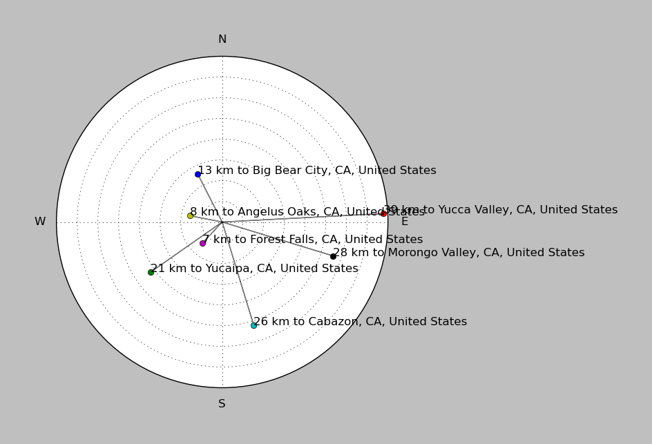
| ||||||||||||||||
Event and active stations
|
|||||||||||||||||
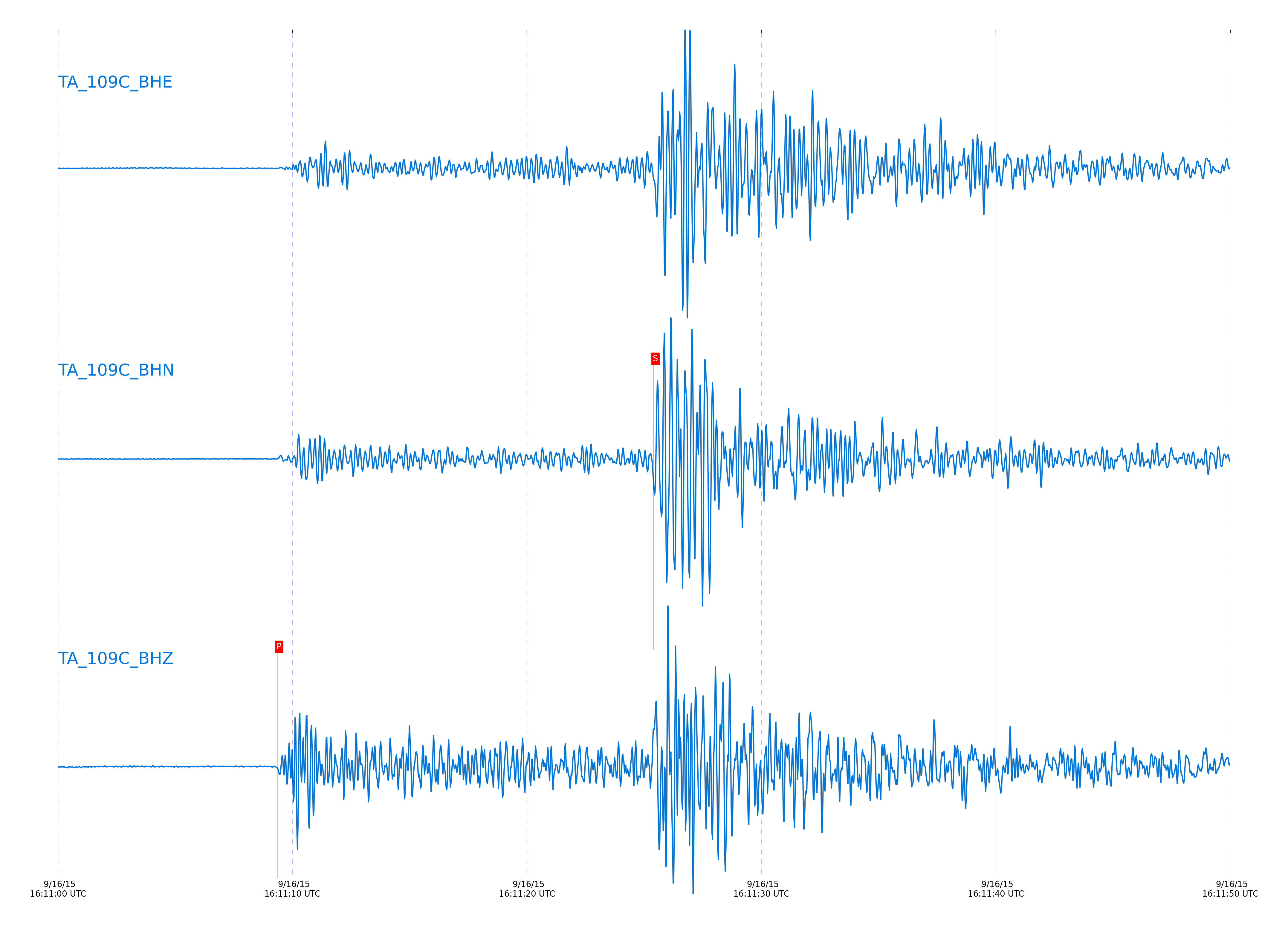
Seismic waveforms for closest station
Closest station with identified signal. Closest station is not filtered. List of vertical stations have a 0.8 to 3 Hz Butterworth bandpass filter applied.
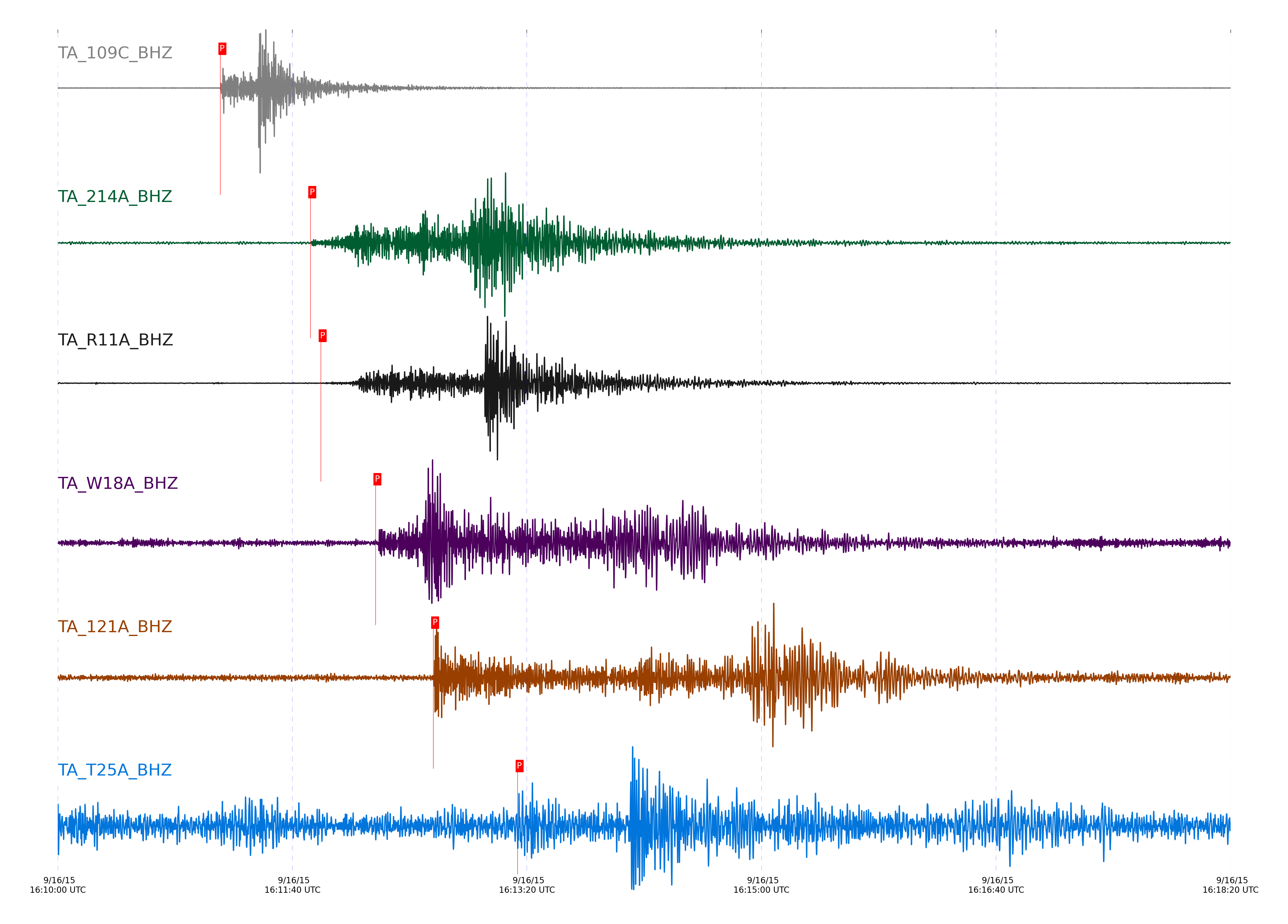
Seismic waveforms for vertical channels in network
Subset of several stations close to the event. Closest station is not filtered. List of vertical stations have a 0.8 to 3 Hz Butterworth bandpass filter applied.
Signal description at some stations
| STA_CHAN | S-E Delta | S-E Azimuth | Phase | Time | Signal/Noise | Time Residual | V. Model | Auth | arid |
|---|---|---|---|---|---|---|---|---|---|
| 109C_BHZ | 1.265° | 9.3° | Pn | 2015-09-16 16:11:09.3484 UTC | 107.39 | -1.57 | iasp91 | dbp:vladik:1525 | 16058978 |
| 214A_BHZ | 4.032° | 303.84° | Pn | 2015-09-16 16:11:47.7046 UTC | -1 | -1.264 | iasp91 | dbp:vladik:1525 | 16059021 |
| R11A_BHZ | 4.335° | 194.08° | Pn | 2015-09-16 16:11:52.1362 UTC | -1 | -0.992 | iasp91 | dbp:vladik:1525 | 16059022 |
| W18A_BHZ | 5.941° | 262.54° | Pn | 2015-09-16 16:12:15.4527 UTC | 7.2772 | 0.255 | iasp91 | dbp:vladik:1525 | 16059025 |
| 121A_BHZ | 7.745° | 284.43° | Pn | 2015-09-16 16:12:40.0573 UTC | 21.117 | 0.084 | iasp91 | dbp:vladik:1525 | 16059026 |
| T25A_BHZ | 10.543° | 257.17° | Pn | 2015-09-16 16:13:16.0197 UTC | -1 | -2.301 | iasp91 | dbp:vladik:1525 | 16059028 |
External resources
Current seismic activity measured by the seismic network
Click the link below to observe an interactive map of earthquakes recorded by the station deployment: