last update to page: September 03 2017 03:54:34 (UTC).
Magnitude 5.3 Earthquake: Eastern Idaho
SummaryThe red marker denotes the earthquake epicenter. On Sat Sep 2nd 2017 23:56:52 (UTC) the seismic network recorded an earthquake (preliminary 5.3 mww) located in Eastern Idaho. Seismic region Eastern North America. The epicentral distance (i.e. distance separating the location to the epicenter) to the closest station H17A in the network is 207.8 km. If you felt the quake, the USGS would like to know. Please add your comments to the USGS page "Did you feel it?". |
Details
Proximity to Population Centers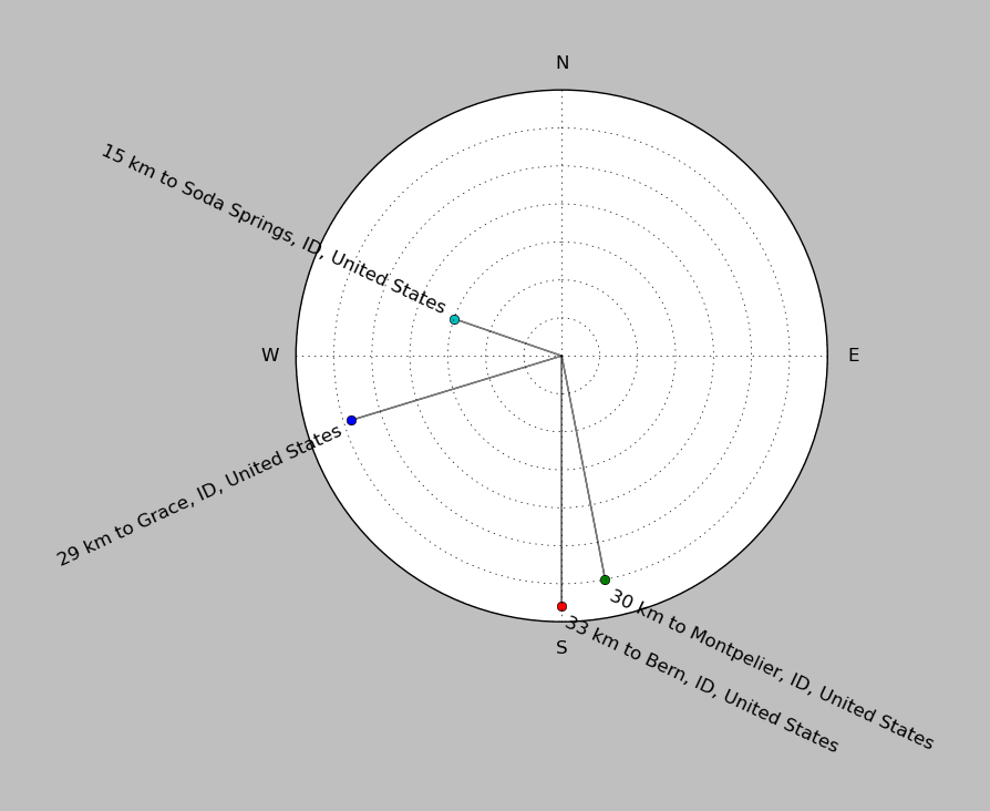
| ||||||||||||||||
Event and active stations
|
|||||||||||||||||
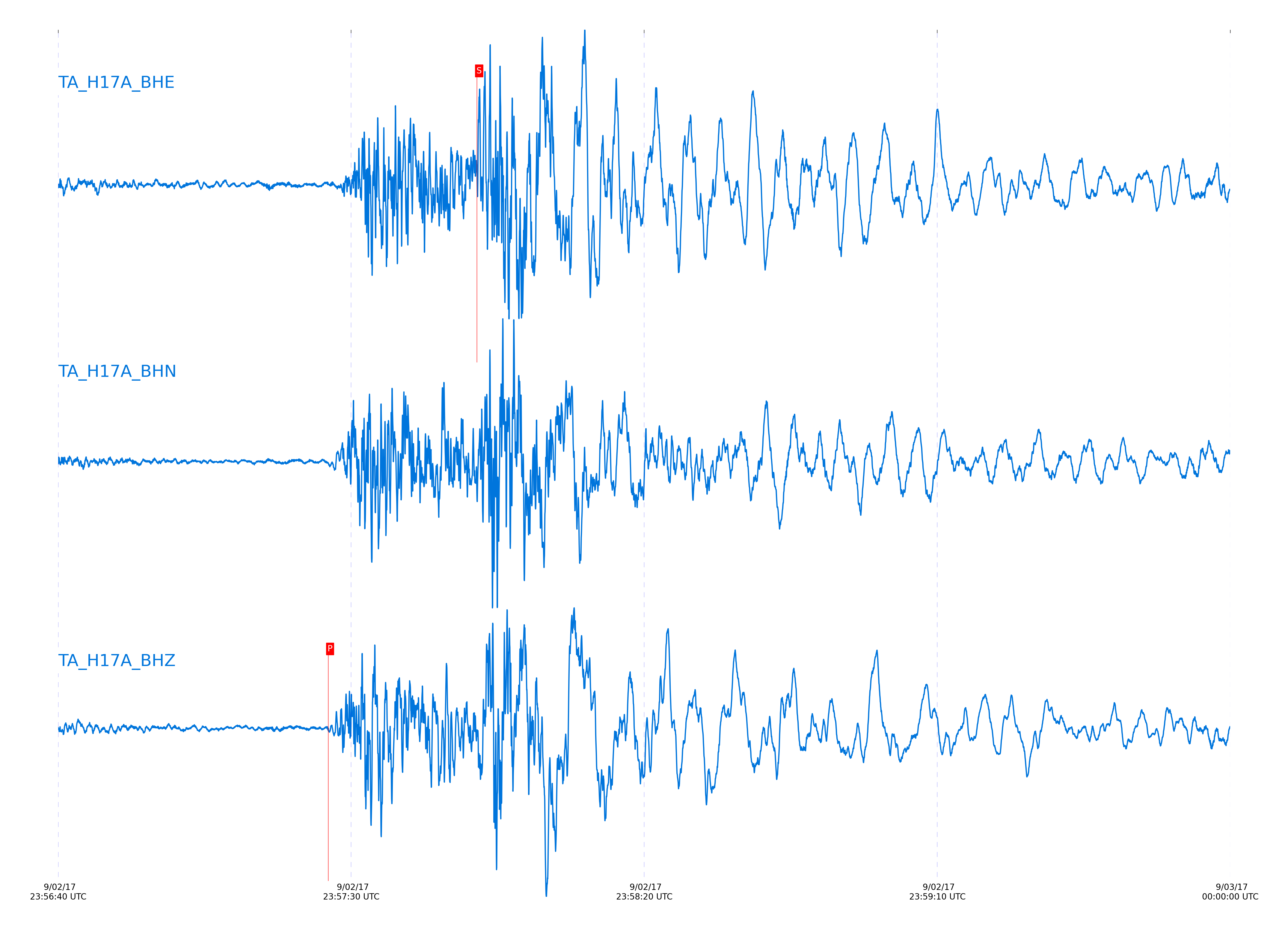
Seismic waveforms for closest station
Closest station with identified signal. Not filtered.
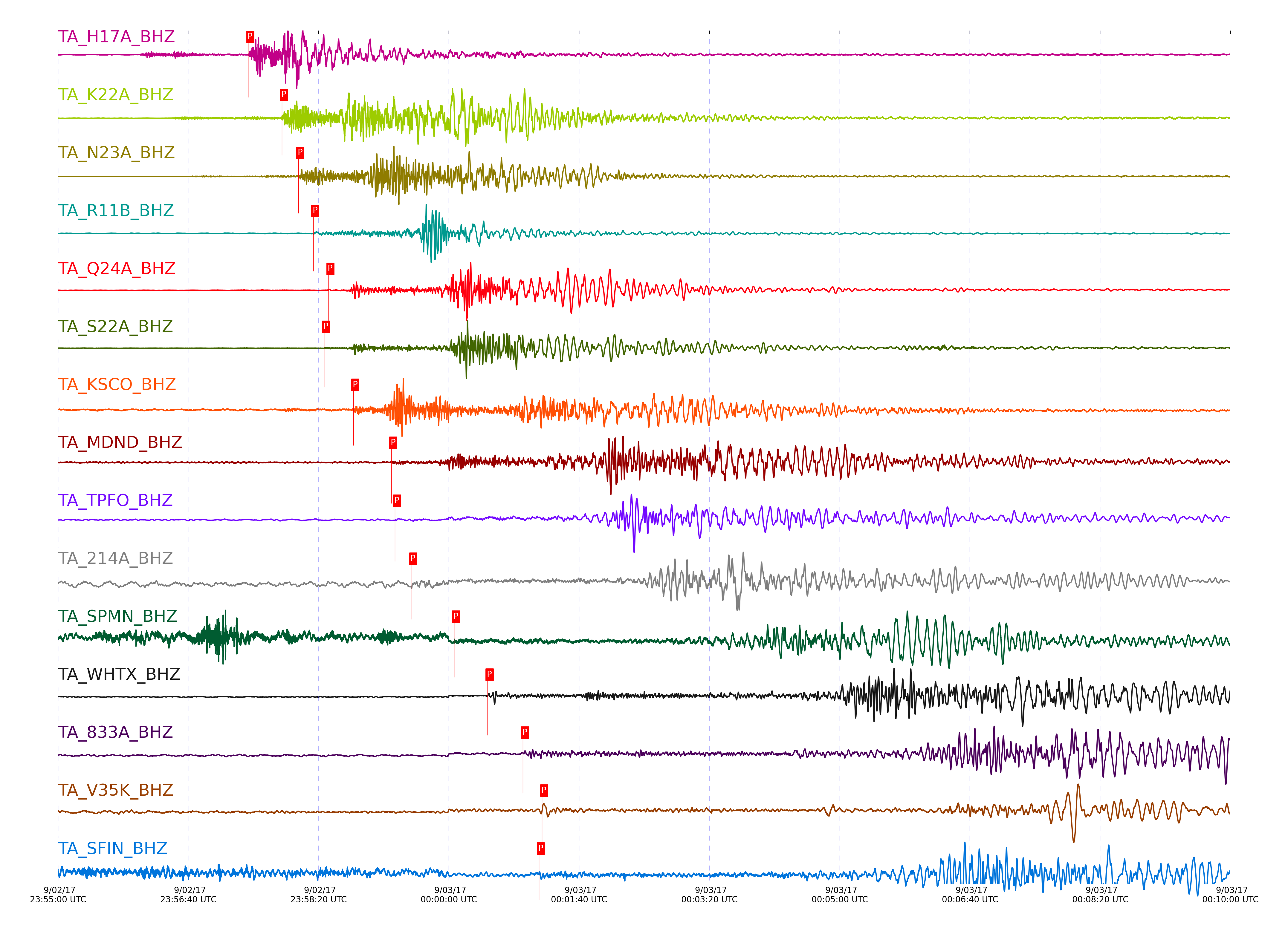
Seismic waveforms for vertical channels in network
Subset of several stations close to the event. Not filtered.
Signal description at some stations
| STA_CHAN | S-E Delta | S-E Azimuth | Phase | Time | Signal/Noise | Time Residual | V. Model | Auth | arid |
|---|---|---|---|---|---|---|---|---|---|
| H17A_BHZ | 1.867° | 198.73° | Pb | 2017-09-02 23:57:26.0686 UTC | -1 | -1.021 | iasp91 | dbp:jtytell:172 | 4114007 |
| K22A_BHZ | 3.58° | 271.23° | pPn | 2017-09-02 23:57:51.8813 UTC | -1 | 1.177 | iasp91 | dbp:jtytell:172 | 4114011 |
| N23A_BHZ | 4.415° | 294.86° | pPn | 2017-09-02 23:58:04.4985 UTC | -1 | 2.316 | iasp91 | dbp:jtytell:172 | 4114012 |
| R11B_BHZ | 5.333° | 35.39° | pPn | 2017-09-02 23:58:15.9508 UTC | -1 | 1.144 | iasp91 | dbp:jtytell:172 | 4114090 |
| Q24A_BHZ | 5.974° | 309.77° | PnPn | 2017-09-02 23:58:27.5742 UTC | -1 | -1.373 | iasp91 | dbp:jtytell:172 | 4114091 |
| S22A_BHZ | 5.993° | 325.91° | pPn | 2017-09-02 23:58:24.2553 UTC | 9.4226 | 0.384 | iasp91 | dbp:jtytell:172 | 4113657 |
| KSCO_BHZ | 7.547° | 301.4° | pPn | 2017-09-02 23:58:46.731 UTC | -1 | 1.521 | iasp91 | dbp:jtytell:172 | 4114093 |
| MDND_BHZ | 9.791° | 242.11° | pPn | 2017-09-02 23:59:15.8362 UTC | -1 | -0.16 | iasp91 | dbp:jtytell:172 | 4114101 |
| TPFO_BHZ | 9.854° | 22.3° | pPn | 2017-09-02 23:59:18.787 UTC | 8.2302 | 1.929 | iasp91 | dbp:jtytell:172 | 4113695 |
| 214A_BHZ | 10.728° | 5.63° | pPn | 2017-09-02 23:59:31.0981 UTC | 6.8178 | 2.275 | iasp91 | dbp:jtytell:172 | 4113709 |
| SPMN_BHZ | 13.605° | 265.58° | Pn | 2017-09-03 00:00:04.0111 UTC | 13.946 | -1.931 | iasp91 | dbp:jtytell:172 | 4113715 |
| WHTX_BHZ | 15.32° | 317.88° | Pn | 2017-09-03 00:00:29.7875 UTC | 6.1982 | 0.321 | iasp91 | dbp:jtytell:172 | 4113717 |
| 833A_BHZ | 17.28° | 329.01° | pPn | 2017-09-03 00:00:56.9102 UTC | 9.1511 | 0.223 | iasp91 | dbp:jtytell:172 | 4113723 |
| V35K_BHZ | 18.247° | 125.67° | pP | 2017-09-03 00:01:11.6314 UTC | 6.7068 | 2.602 | iasp91 | dbp:jtytell:172 | 4113727 |
| SFIN_BHZ | 18.269° | 285.05° | pP | 2017-09-03 00:01:09.2018 UTC | -1 | -0.063 | iasp91 | dbp:jtytell:172 | 4114200 |
| T35M_BHZ | 18.694° | 132.09° | pPn | 2017-09-03 00:01:14.066 UTC | 13.79 | -0.079 | iasp91 | dbp:jtytell:172 | 4113729 |
| U33K_BHZ | 19.394° | 124.87° | P | 2017-09-03 00:01:25.0419 UTC | -1 | -0.377 | iasp91 | dbp:jtytell:172 | 4114202 |
| S34M_BHZ | 19.671° | 132.41° | pPn | 2017-09-03 00:01:25.3488 UTC | 9.4567 | -0.591 | iasp91 | dbp:jtytell:172 | 4113739 |
| O48B_BHZ | 19.729° | 285.51° | pP | 2017-09-03 00:01:24.996 UTC | 17.206 | -0.296 | iasp91 | dbp:jtytell:172 | 4113737 |
| P49A_BHZ | 20.257° | 287.44° | Pn | 2017-09-03 00:01:29.6411 UTC | 9.5413 | -0.757 | iasp91 | dbp:jtytell:172 | 4113741 |
| R33M_BHZ | 20.64° | 135.62° | pP | 2017-09-03 00:01:35.763 UTC | 29.51 | 0.55 | iasp91 | dbp:jtytell:172 | 4113743 |
| Q32M_BHZ | 20.817° | 132.45° | P | 2017-09-03 00:01:38.0974 UTC | 13.508 | -0.45 | iasp91 | dbp:jtytell:172 | 4113745 |
| R32K_BHZ | 21.278° | 127.21° | P | 2017-09-03 00:01:42.754 UTC | -1 | -0.036 | iasp91 | dbp:jtytell:172 | 4114203 |
| P32M_BHZ | 21.788° | 131.15° | P | 2017-09-03 00:01:47.4383 UTC | -1 | -0.042 | iasp91 | dbp:jtytell:172 | 4114204 |
| P33M_BHZ | 21.876° | 133.83° | P | 2017-09-03 00:01:48.0327 UTC | 17.684 | -0.257 | iasp91 | dbp:jtytell:172 | 4113753 |
| N32M_BHZ | 22.626° | 135.02° | pP | 2017-09-03 00:01:55.9676 UTC | 9.6816 | -0.583 | iasp91 | dbp:jtytell:172 | 4113757 |
| O53A_BHZ | 22.627° | 285.97° | pP | 2017-09-03 00:01:58.2892 UTC | 26.858 | 0.312 | iasp91 | dbp:jtytell:172 | 4113759 |
| M53A_BHZ | 22.72° | 283.32° | pP | 2017-09-03 00:01:58.7672 UTC | 10.965 | -0.062 | iasp91 | dbp:jtytell:172 | 4113761 |
| P30M_BHZ | 23.389° | 126.87° | pP | 2017-09-03 00:02:03.9606 UTC | -1 | -0.658 | iasp91 | dbp:jtytell:172 | 4114206 |
| P29M_BHZ | 23.418° | 124.75° | pP | 2017-09-03 00:02:03.9201 UTC | 5.527 | -1.006 | iasp91 | dbp:jtytell:172 | 4113765 |
| O30N_BHZ | 23.452° | 129.41° | pP | 2017-09-03 00:02:04.7217 UTC | -1 | -0.564 | iasp91 | dbp:jtytell:172 | 4114207 |
| N31M_BHZ | 23.801° | 131.16° | pP | 2017-09-03 00:02:07.8728 UTC | 9.0509 | -0.857 | iasp91 | dbp:jtytell:172 | 4113771 |
| M31M_BHZ | 23.807° | 134.58° | pP | 2017-09-03 00:02:07.8723 UTC | -1 | -0.921 | iasp91 | dbp:jtytell:172 | 4114600 |
| M30M_BHZ | 24.877° | 131.38° | pP | 2017-09-03 00:02:18.5166 UTC | 8.6717 | -0.038 | iasp91 | dbp:jtytell:172 | 4113773 |
| M29M_BHZ | 25.382° | 128.63° | pP | 2017-09-03 00:02:24.8468 UTC | 16.408 | -0.462 | iasp91 | dbp:jtytell:172 | 4113775 |
| L29M_BHZ | 25.686° | 130.2° | pP | 2017-09-03 00:02:27.4855 UTC | 8.651 | -0.934 | iasp91 | dbp:jtytell:172 | 4113777 |
| K29M_BHZ | 25.966° | 132.26° | pP | 2017-09-03 00:02:28.1823 UTC | 9.62 | -0.264 | iasp91 | dbp:jtytell:172 | 4113779 |
| J30M_BHZ | 26.097° | 135.15° | pP | 2017-09-03 00:02:29.5946 UTC | 14.372 | -0.043 | iasp91 | dbp:jtytell:172 | 4113783 |
| H31M_BHZ | 26.441° | 139.88° | P | 2017-09-03 00:02:33.9354 UTC | -1 | 0.575 | iasp91 | dbp:jtytell:172 | 4114602 |
| I30M_BHZ | 26.573° | 135.99° | pP | 2017-09-03 00:02:33.4841 UTC | 15.319 | -0.456 | iasp91 | dbp:jtytell:172 | 4113787 |
| M27K_BHZ | 26.61° | 123.55° | pP | 2017-09-03 00:02:33.7529 UTC | 5.9082 | -0.52 | iasp91 | dbp:jtytell:172 | 4113785 |
| M26K_BHZ | 27.069° | 122.07° | pP | 2017-09-03 00:02:38.2701 UTC | -1 | -0.142 | iasp91 | dbp:jtytell:172 | 4114603 |
| I29M_BHZ | 27.244° | 133.31° | pP | 2017-09-03 00:02:38.798 UTC | 5.6271 | -1.188 | iasp91 | dbp:jtytell:172 | 4113793 |
| G31M_BHZ | 27.287° | 141.39° | P | 2017-09-03 00:02:38.8939 UTC | 9.9966 | 1.329 | iasp91 | dbp:jtytell:172 | 4113791 |
| N25K_BHZ | 27.317° | 118.58° | pP | 2017-09-03 00:02:40.8428 UTC | -1 | 0.204 | iasp91 | dbp:jtytell:172 | 4114604 |
| EPYK_BHZ | 27.503° | 137.03° | pP | 2017-09-03 00:02:41.8107 UTC | -1 | -0.493 | iasp91 | dbp:jtytell:172 | 4114605 |
| K27K_BHZ | 27.636° | 125.95° | pP | 2017-09-03 00:02:43.0721 UTC | -1 | -0.431 | iasp91 | dbp:jtytell:172 | 4114606 |
| I28M_BHZ | 27.805° | 131.08° | pP | 2017-09-03 00:02:43.9515 UTC | 15.986 | -1.065 | iasp91 | dbp:jtytell:172 | 4113795 |
| G29M_BHZ | 28.251° | 135.83° | pP | 2017-09-03 00:02:48.4048 UTC | -1 | -0.592 | iasp91 | dbp:jtytell:172 | 4114607 |
| J26L_BHZ | 28.436° | 124.63° | pP | 2017-09-03 00:02:50.4359 UTC | 15.593 | -0.213 | iasp91 | dbp:jtytell:172 | 4113799 |
| H27K_BHZ | 28.809° | 129.95° | pP | 2017-09-03 00:02:52.9259 UTC | 7.4229 | -1.038 | iasp91 | dbp:jtytell:172 | 4113801 |
| F28M_BHZ | 29.253° | 134.11° | pP | 2017-09-03 00:02:57.1876 UTC | 7.3403 | -0.723 | iasp91 | dbp:jtytell:172 | 4113805 |
| E29M_BHZ | 29.296° | 137.85° | pP | 2017-09-03 00:02:57.6039 UTC | 7.1536 | -0.691 | iasp91 | dbp:jtytell:172 | 4113803 |
| E28M_BHZ | 29.864° | 135.81° | pP | 2017-09-03 00:03:02.6351 UTC | 17.033 | -0.693 | iasp91 | dbp:jtytell:172 | 4113807 |
| G26K_BHZ | 29.958° | 127.87° | pP | 2017-09-03 00:03:03.5972 UTC | 5.1664 | -0.567 | iasp91 | dbp:jtytell:172 | 4113809 |
| E27K_BHZ | 30.117° | 132.46° | pP | 2017-09-03 00:03:05.5397 UTC | 12.82 | -0.029 | iasp91 | dbp:jtytell:172 | 4113811 |
| F26K_BHZ | 30.528° | 128.4° | pP | 2017-09-03 00:03:09.3236 UTC | -1 | 0.128 | iasp91 | dbp:jtytell:172 | 4114609 |
| H24K_BHZ | 30.682° | 120.97° | pP | 2017-09-03 00:03:10.3698 UTC | 13.033 | -0.189 | iasp91 | dbp:jtytell:172 | 4113813 |
| I23K_BHZ | 30.878° | 118.1° | pP | 2017-09-03 00:03:11.7113 UTC | -1 | -0.57 | iasp91 | dbp:jtytell:172 | 4114610 |
| G24K_BHZ | 31° | 122.71° | pP | 2017-09-03 00:03:13.0435 UTC | 6.509 | -0.317 | iasp91 | dbp:jtytell:172 | 4113816 |
| F24K_BHZ | 31.58° | 123.31° | pP | 2017-09-03 00:03:18.5582 UTC | 9.005 | 0.093 | iasp91 | dbp:jtytell:172 | 4113822 |
| G23K_BHZ | 31.868° | 119.53° | pP | 2017-09-03 00:03:20.6758 UTC | -1 | -0.32 | iasp91 | dbp:jtytell:172 | 4114612 |
| I21K_BHZ | 31.877° | 114.96° | pP | 2017-09-03 00:03:20.5643 UTC | 6.4656 | -0.51 | iasp91 | dbp:jtytell:172 | 4113824 |
| J20K_BHZ | 32.338° | 110.96° | pP | 2017-09-03 00:03:23.941 UTC | -1 | -1.176 | iasp91 | dbp:jtytell:172 | 4114613 |
| H21K_BHZ | 32.388° | 114.68° | pP | 2017-09-03 00:03:25.1363 UTC | 5.0856 | -0.417 | iasp91 | dbp:jtytell:172 | 4113826 |
| G22K_BHZ | 32.481° | 118.01° | pP | 2017-09-03 00:03:26.3014 UTC | -1 | -0.069 | iasp91 | dbp:jtytell:172 | 4114615 |
| I20K_BHZ | 32.696° | 111.48° | pP | 2017-09-03 00:03:28.2692 UTC | -1 | 0.025 | iasp91 | dbp:jtytell:172 | 4114616 |
| TOLK_BHZ | 32.719° | 122.7° | pP | 2017-09-03 00:03:28.7576 UTC | -1 | 0.31 | iasp91 | dbp:jtytell:172 | 4114617 |
| D24K_BHZ | 32.777° | 124.3° | pP | 2017-09-03 00:03:29.0099 UTC | -1 | 0.056 | iasp91 | dbp:jtytell:172 | 4114618 |
| J19K_BHZ | 32.881° | 109.02° | pP | 2017-09-03 00:03:29.2586 UTC | 7.3094 | -0.609 | iasp91 | dbp:jtytell:172 | 4113828 |
| G21K_BHZ | 33.007° | 115.06° | pP | 2017-09-03 00:03:30.8902 UTC | -1 | -0.071 | iasp91 | dbp:jtytell:172 | 4114619 |
| C24K_BHZ | 33.064° | 125.17° | pP | 2017-09-03 00:03:31.3925 UTC | -1 | -0.071 | iasp91 | dbp:jtytell:172 | 4114620 |
| H20K_BHZ | 33.111° | 112.02° | pP | 2017-09-03 00:03:31.4486 UTC | 15.828 | -0.42 | iasp91 | dbp:jtytell:172 | 4113830 |
| J18K_BHZ | 33.178° | 107.03° | pP | 2017-09-03 00:03:32.3841 UTC | -1 | -0.072 | iasp91 | dbp:jtytell:172 | 4114622 |
| D23K_BHZ | 33.231° | 121.76° | pP | 2017-09-03 00:03:33.0349 UTC | -1 | 0.118 | iasp91 | dbp:jtytell:172 | 4114621 |
| H19K_BHZ | 33.73° | 110.29° | pP | 2017-09-03 00:03:36.4222 UTC | 10.135 | -0.834 | iasp91 | dbp:jtytell:172 | 4113832 |
| E20K_BHZ | 34.671° | 114.3° | pP | 2017-09-03 00:03:45.2701 UTC | 7.3753 | -0.142 | iasp91 | dbp:jtytell:172 | 4113834 |
| F19K_BHZ | 34.687° | 110.6° | pP | 2017-09-03 00:03:45.0226 UTC | -1 | -0.522 | iasp91 | dbp:jtytell:172 | 4114925 |
| G18K_BHZ | 34.707° | 108.35° | pP | 2017-09-03 00:03:45.103 UTC | -1 | -0.617 | iasp91 | dbp:jtytell:172 | 4114926 |
| E19K_BHZ | 34.718° | 112.05° | pP | 2017-09-03 00:03:45.8611 UTC | 8.4585 | 0.048 | iasp91 | dbp:jtytell:172 | 4113836 |
| D20K_BHZ | 35.001° | 114.41° | pP | 2017-09-03 00:03:48.2091 UTC | -1 | -0.048 | iasp91 | dbp:jtytell:172 | 4114927 |
| D19K_BHZ | 35.417° | 112.42° | pP | 2017-09-03 00:03:51.6284 UTC | 6.3462 | -0.209 | iasp91 | dbp:jtytell:172 | 4113842 |
External resources
Current seismic activity measured by the seismic network
Click the link below to observe an interactive map of earthquakes recorded by the station deployment: