last update to page: December 08 2016 19:58:13 (UTC).
Magnitude 6.4 Earthquake: Northern Sumatra, Indonesia
SummaryThe red marker denotes the earthquake epicenter. On Tue Dec 6th 2016 22:03:34 (UTC) the seismic network recorded an earthquake (preliminary 6.4 mwp) located in Northern Sumatra, Indonesia. Seismic region Andaman Islands To Sumatra. The epicentral distance (i.e. distance separating the location to the epicenter) to the closest station A21K in the network is 10,058.3 km. If you felt the quake, the USGS would like to know. Please add your comments to the USGS page "Did you feel it?". |
Details
Proximity to Population Centers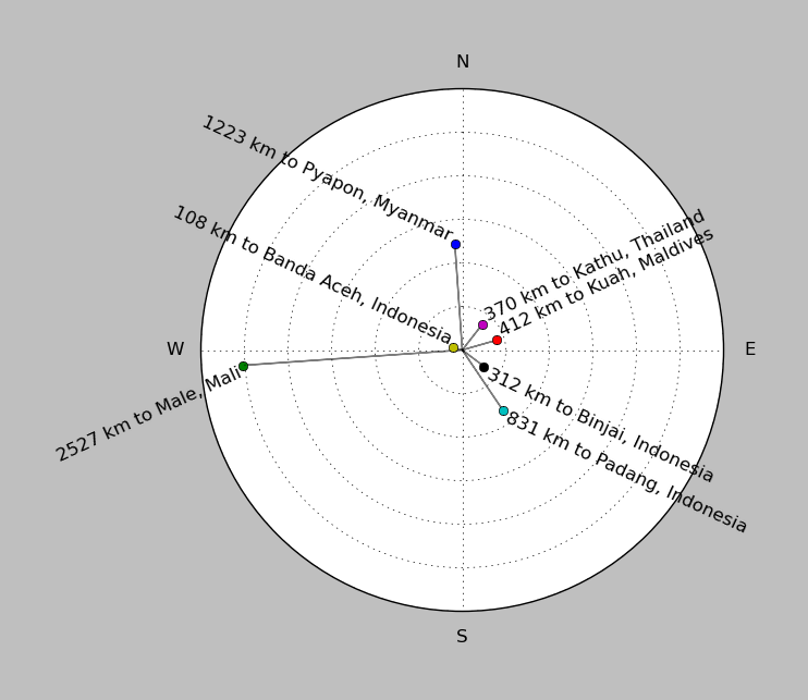
| ||||||||||||||||
Event and active stations
|
|||||||||||||||||
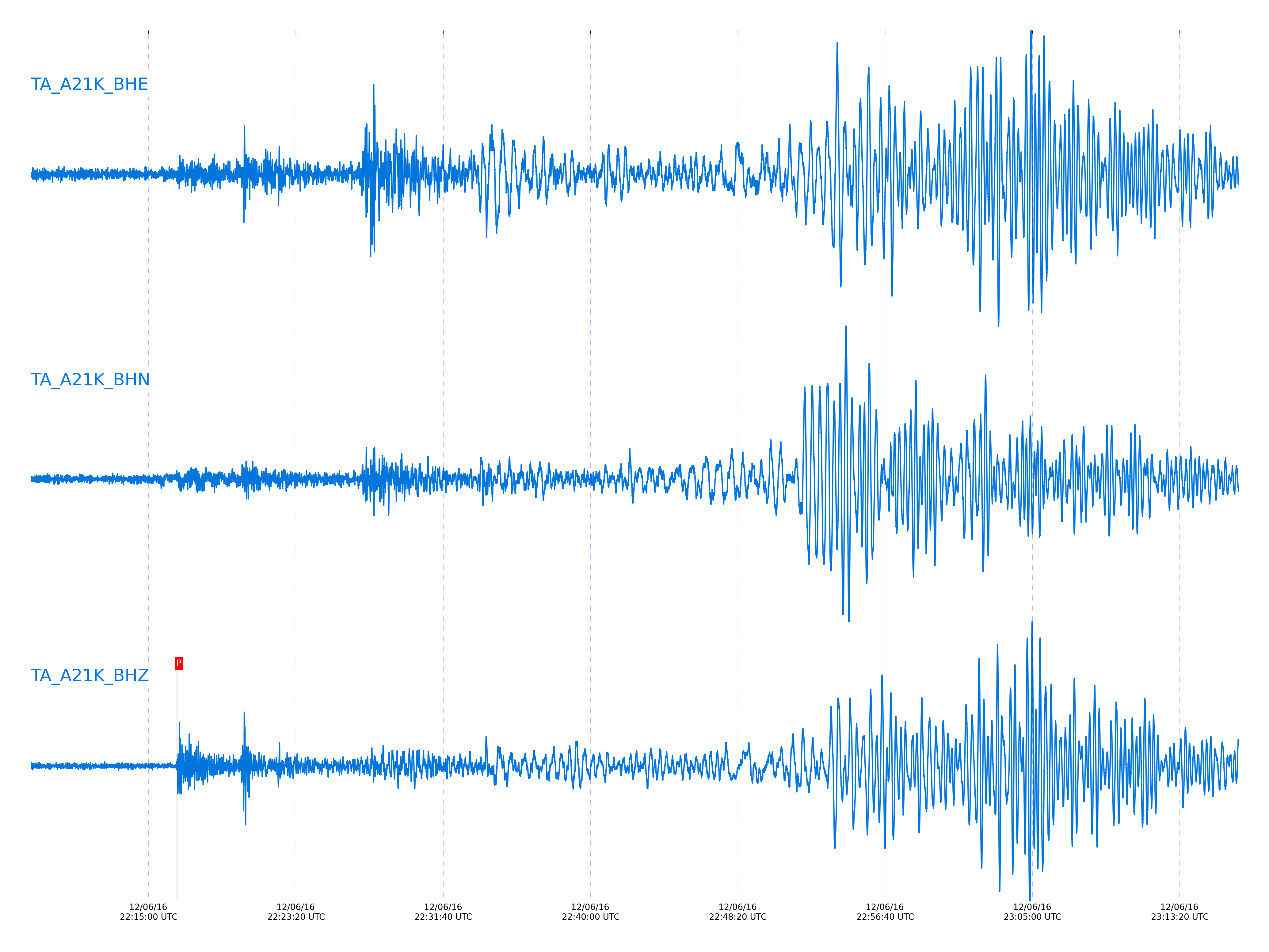
Seismic waveforms for closest station
Closest station with identified signal. Not filtered.
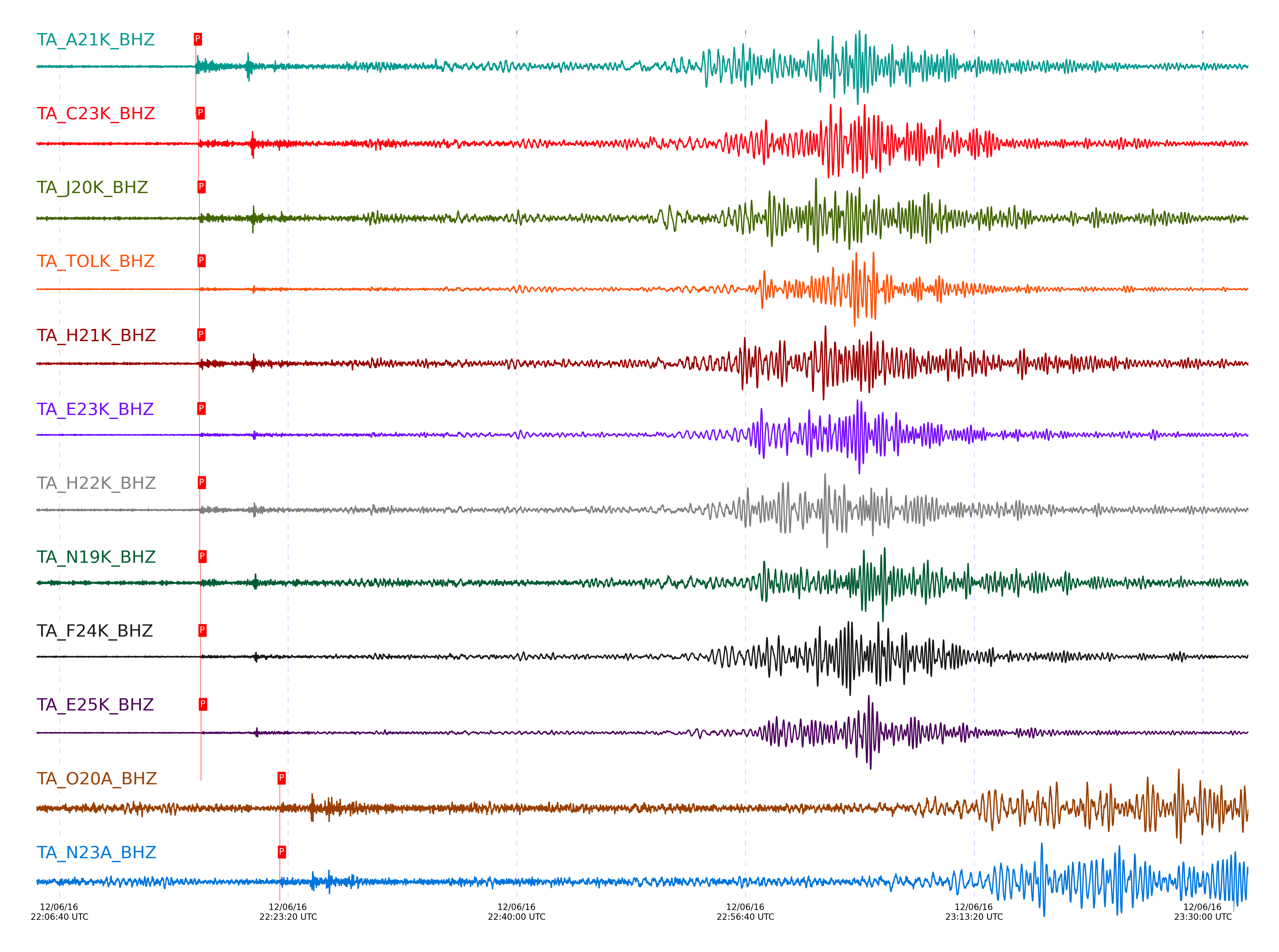
Seismic waveforms for vertical channels in network
Subset of several stations close to the event. Not filtered.
Signal description at some stations
| STA_CHAN | S-E Delta | S-E Azimuth | Phase | Time | Signal/Noise | Time Residual | V. Model | Auth | arid |
|---|---|---|---|---|---|---|---|---|---|
| A21K_BHZ | 90.355° | 287.89° | PcP | 2016-12-06 22:16:36.6378 UTC | 44.191 | 0.539 | iasp91 | dbp:vladik:1634 | 3408246 |
| C23K_BHZ | 92.747° | 293.54° | PcP | 2016-12-06 22:16:48.1274 UTC | 19.691 | 1.434 | iasp91 | dbp:vladik:1634 | 3408247 |
| J20K_BHZ | 93.561° | 289.96° | PcP | 2016-12-06 22:16:52.5368 UTC | 10.717 | 2.233 | iasp91 | dbp:vladik:1634 | 3408243 |
| TOLK_BHZ | 93.57° | 294.46° | PcP | 2016-12-06 22:16:52.6906 UTC | 30.265 | 2.349 | iasp91 | dbp:vladik:1634 | 3408248 |
| H21K_BHZ | 93.572° | 291.28° | PcP | 2016-12-06 22:16:50.8435 UTC | 26.328 | 0.491 | iasp91 | dbp:vladik:1634 | 3408249 |
| E23K_BHZ | 93.796° | 294.38° | PcP | 2016-12-06 22:16:51.8685 UTC | 17.699 | 0.524 | iasp91 | dbp:vladik:1634 | 3408252 |
| H22K_BHZ | 94.027° | 292.61° | PcP | 2016-12-06 22:16:53.5711 UTC | 38.349 | 1.201 | iasp91 | dbp:vladik:1634 | 3408250 |
| N19K_BHZ | 94.548° | 289.43° | PcP | 2016-12-06 22:16:56.5968 UTC | 10.042 | 1.914 | iasp91 | dbp:vladik:1634 | 3408251 |
| F24K_BHZ | 94.617° | 295.97° | PcP | 2016-12-06 22:16:56.525 UTC | 21.046 | 1.538 | iasp91 | dbp:vladik:1634 | 3408254 |
| E25K_BHZ | 95.122° | 298.2° | PcP | 2016-12-06 22:16:58.7 UTC | 6.8554 | 1.471 | iasp91 | dbp:vladik:1634 | 3408245 |
| O20A_BHZ | 129.273° | 327.75° | PKiKP | 2016-12-06 22:22:43.0929 UTC | 17.578 | 0.149 | iasp91 | dbp:vladik:1634 | 3408276 |
| N23A_BHZ | 129.513° | 330.8° | PKiKP | 2016-12-06 22:22:43.974 UTC | 6.3375 | 0.549 | iasp91 | dbp:vladik:1634 | 3408277 |
External resources
Current seismic activity measured by the seismic network
Click the link below to observe an interactive map of earthquakes recorded by the station deployment: