last update to page: March 15 2016 17:32:37 (UTC).
Magnitude 6.3 Earthquake: Andreanof Islands, Aleutian Is.
SummaryThe red marker denotes the earthquake epicenter. On Sat Mar 12th 2016 18:06:46 (UTC) the seismic network recorded an earthquake (preliminary 6.3 mww) located in Andreanof Islands, Aleutian Is.. Seismic region Alaska - Aleutian Arc. The epicentral distance (i.e. distance separating the location to the epicenter) to the closest station P18K in the network is 1,457.6 km. If you felt the quake, the USGS would like to know. Please add your comments to the USGS page "Did you feel it?". |
Details
Proximity to Population Centers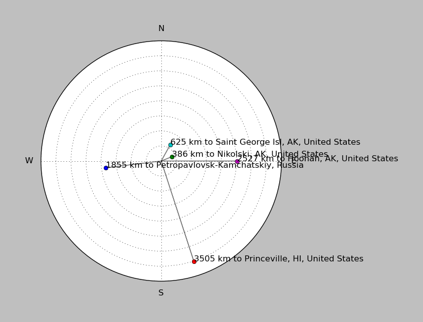
| ||||||||||||||||
Event and active stations
|
|||||||||||||||||
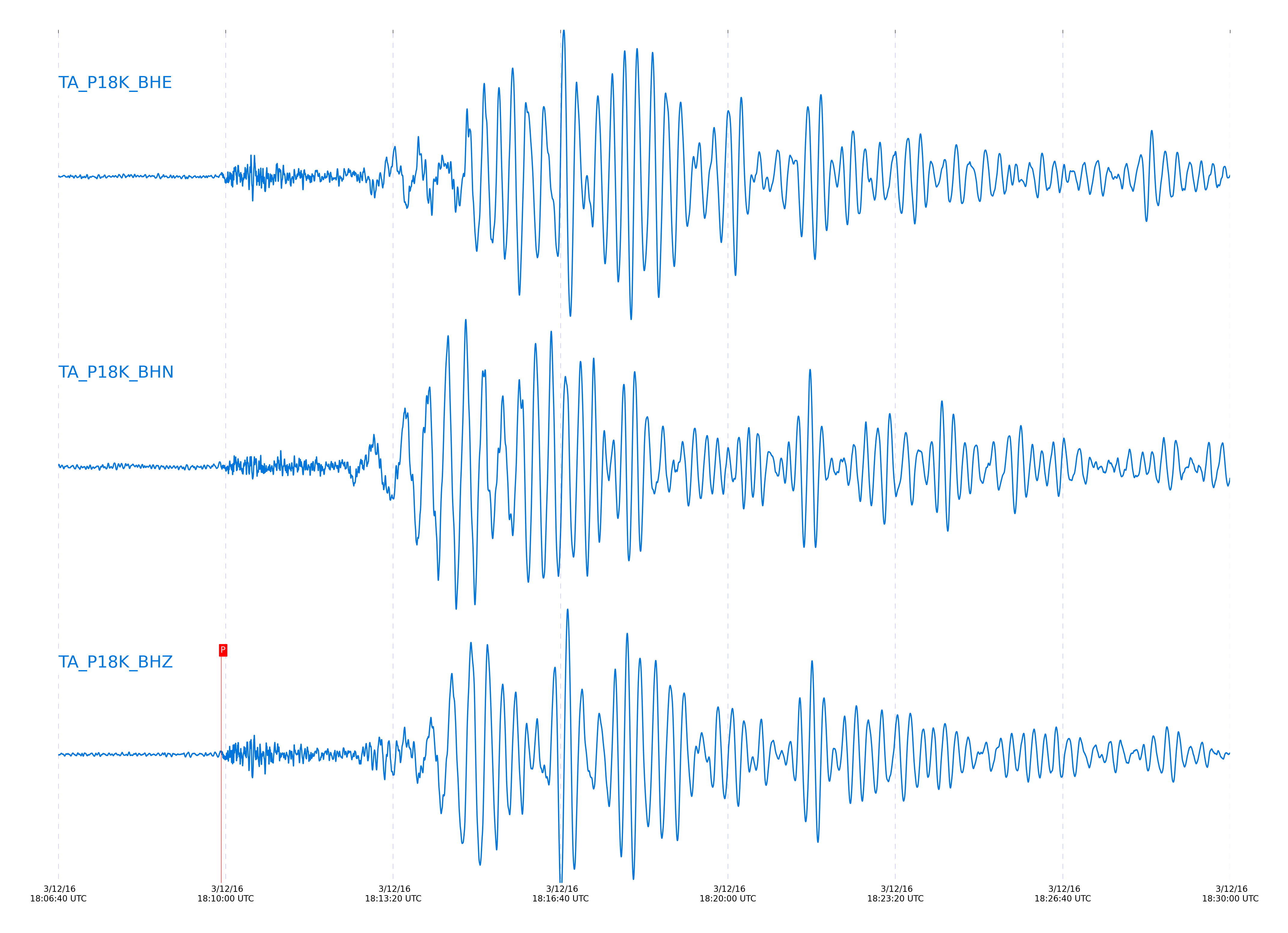
Seismic waveforms for closest station
Closest station with identified signal. Not filtered.
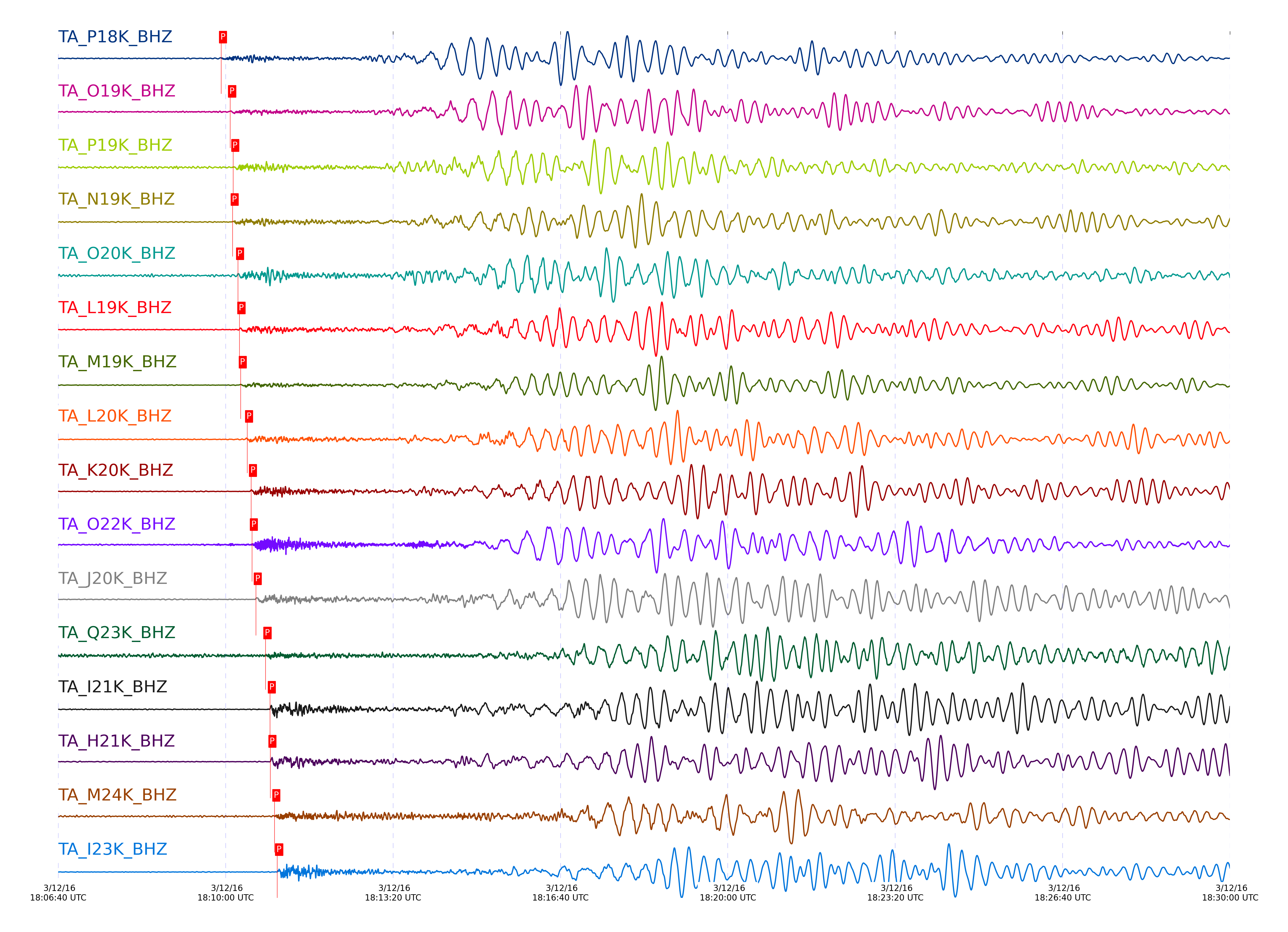
Seismic waveforms for vertical channels in network
Subset of several stations close to the event. Not filtered.
Signal description at some stations
| STA_CHAN | S-E Delta | S-E Azimuth | Phase | Time | Signal/Noise | Time Residual | V. Model | Auth | arid |
|---|---|---|---|---|---|---|---|---|---|
| P18K_BHZ | 13.093° | 241.89° | pPn | 2016-03-12 18:09:54.6527 UTC | -1 | -1.264 | iasp91 | dbp:mcwhite:160 | 2854605 |
| O19K_BHZ | 13.881° | 240.66° | pPn | 2016-03-12 18:10:05.5237 UTC | 31.265 | -1.143 | iasp91 | dbp:mcwhite:160 | 2851214 |
| P19K_BHZ | 14.115° | 244.54° | pPn | 2016-03-12 18:10:09.1463 UTC | -1 | -0.72 | iasp91 | dbp:mcwhite:160 | 2854607 |
| N19K_BHZ | 14.125° | 238.22° | pPn | 2016-03-12 18:10:08.4869 UTC | -1 | -1.522 | iasp91 | dbp:mcwhite:160 | 2854608 |
| O20K_BHZ | 14.576° | 244.07° | pPn | 2016-03-12 18:10:14.9138 UTC | 13.296 | -1.242 | iasp91 | dbp:mcwhite:160 | 2851197 |
| L19K_BHZ | 14.752° | 233.11° | pPn | 2016-03-12 18:10:16.575 UTC | 61.893 | -1.978 | iasp91 | dbp:mcwhite:160 | 2851217 |
| M19K_BHZ | 14.764° | 234.86° | pPn | 2016-03-12 18:10:18.15 UTC | 143.76 | -0.568 | iasp91 | dbp:mcwhite:160 | 2851220 |
| L20K_BHZ | 15.292° | 234.09° | pPn | 2016-03-12 18:10:25.7906 UTC | -1 | -0.13 | iasp91 | dbp:mcwhite:160 | 2854609 |
| K20K_BHZ | 15.756° | 231.21° | P | 2016-03-12 18:10:30.4121 UTC | -1 | 0.114 | iasp91 | dbp:mcwhite:160 | 2854611 |
| O22K_BHZ | 16.051° | 247.41° | Pn | 2016-03-12 18:10:31.5278 UTC | 59.903 | 0.489 | iasp91 | dbp:mcwhite:160 | 2851232 |
| J20K_BHZ | 16.257° | 228.88° | P | 2016-03-12 18:10:36.142 UTC | -1 | 0.291 | iasp91 | dbp:mcwhite:160 | 2854612 |
| Q23K_BHZ | 17.324° | 255.47° | P | 2016-03-12 18:10:47.7669 UTC | -1 | 0.103 | iasp91 | dbp:mcwhite:160 | 2854613 |
| I21K_BHZ | 17.612° | 230.3° | Pn | 2016-03-12 18:10:53.0103 UTC | -1 | 0.825 | iasp91 | dbp:mcwhite:160 | 2854614 |
| H21K_BHZ | 17.667° | 227.71° | Pn | 2016-03-12 18:10:53.6011 UTC | -1 | 0.674 | iasp91 | dbp:mcwhite:160 | 2854615 |
| M24K_BHZ | 18.247° | 247.77° | P | 2016-03-12 18:10:58.3498 UTC | 64.113 | 0.502 | iasp91 | dbp:mcwhite:160 | 2851274 |
| I23K_BHZ | 18.467° | 234.81° | Pn | 2016-03-12 18:11:01.6486 UTC | 363.02 | 1.18 | iasp91 | dbp:mcwhite:160 | 2851276 |
| N25K_BHZ | 18.769° | 251.33° | P | 2016-03-12 18:11:03.6 UTC | 55.893 | 0.011 | iasp91 | dbp:mcwhite:160 | 2851282 |
| H23K_BHZ | 18.805° | 232.89° | Pn | 2016-03-12 18:11:05.4149 UTC | -1 | 0.841 | iasp91 | dbp:mcwhite:160 | 2854616 |
| TCOL_BHZ | 18.842° | 237.89° | Pn | 2016-03-12 18:11:05.4803 UTC | 49.855 | 0.462 | iasp91 | dbp:mcwhite:160 | 2851286 |
| POKR_BHZ | 19.125° | 237.95° | Pn | 2016-03-12 18:11:09.069 UTC | 43.444 | 0.642 | iasp91 | dbp:mcwhite:160 | 2851290 |
| H24K_BHZ | 19.365° | 235.53° | Pn | 2016-03-12 18:11:11.7028 UTC | 667.85 | 0.39 | iasp91 | dbp:mcwhite:160 | 2851578 |
| J25K_BHZ | 19.634° | 242.31° | P | 2016-03-12 18:11:12.3787 UTC | 1273.1 | -0.686 | iasp91 | dbp:mcwhite:160 | 2851294 |
| L26K_BHZ | 19.795° | 249.18° | P | 2016-03-12 18:11:15.5168 UTC | 63.907 | 0.691 | iasp91 | dbp:mcwhite:160 | 2851300 |
| M27K_BHZ | 20.216° | 252.83° | P | 2016-03-12 18:11:20.1655 UTC | 182.68 | 0.762 | iasp91 | dbp:mcwhite:160 | 2851579 |
| J26L_BHZ | 20.28° | 245.16° | P | 2016-03-12 18:11:19.917 UTC | -1 | -0.187 | iasp91 | dbp:mcwhite:160 | 2854617 |
| L27K_BHZ | 20.456° | 251.08° | P | 2016-03-12 18:11:22.7013 UTC | -1 | 0.691 | iasp91 | dbp:mcwhite:160 | 2854618 |
| TOLK_BHZ | 20.615° | 226.83° | Pn | 2016-03-12 18:11:25.7268 UTC | 859.39 | -0.354 | iasp91 | dbp:mcwhite:160 | 2851304 |
| A21K_BHZ | 21.188° | 210.88° | Pn | 2016-03-12 18:11:31.589 UTC | 31.438 | -1.152 | iasp91 | dbp:mcwhite:160 | 2851308 |
| J29M_BHZ | 22.409° | 252.24° | P | 2016-03-12 18:11:44.3341 UTC | 130.74 | -0.142 | iasp91 | dbp:mcwhite:160 | 2851313 |
| M30M_BHZ | 22.546° | 258.29° | P | 2016-03-12 18:11:45.0538 UTC | -1 | 0.607 | iasp91 | dbp:mcwhite:160 | 2854620 |
| I29M_BHZ | 22.667° | 250.06° | P | 2016-03-12 18:11:45.9698 UTC | 69.529 | 0.243 | iasp91 | dbp:mcwhite:160 | 2851314 |
| N31M_BHZ | 22.827° | 261.95° | pP | 2016-03-12 18:11:51.3658 UTC | 19.049 | -2.374 | iasp91 | dbp:mcwhite:160 | 2851317 |
| M31M_BHZ | 23.578° | 261.74° | P | 2016-03-12 18:11:57.05 UTC | 24.091 | 1.722 | iasp91 | dbp:mcwhite:160 | 2851319 |
| P33M_BHZ | 24.151° | 267.76° | P | 2016-03-12 18:12:02.2502 UTC | 114.34 | 0.945 | iasp91 | dbp:mcwhite:160 | 2851321 |
| C36M_BHZ | 29.013° | 258.41° | P | 2016-03-12 18:12:44.2218 UTC | 67.456 | -0.008 | iasp91 | dbp:mcwhite:160 | 2851328 |
| A36M_BHZ | 29.298° | 252.54° | P | 2016-03-12 18:12:47.7 UTC | 122.23 | 0.941 | iasp91 | dbp:mcwhite:160 | 2851329 |
| D03D_BHZ | 32.588° | 296.53° | pP | 2016-03-12 18:13:19.6414 UTC | -1 | -2.846 | iasp91 | dbp:mcwhite:160 | 2854621 |
| B05D_BHZ | 32.864° | 295.79° | pP | 2016-03-12 18:13:21.8528 UTC | 27.21 | -3.05 | iasp91 | dbp:mcwhite:160 | 2851336 |
| D04E_BHZ | 32.941° | 297.1° | pP | 2016-03-12 18:13:23.1594 UTC | -1 | -2.412 | iasp91 | dbp:mcwhite:160 | 2854622 |
| F04D_BHZ | 33.307° | 298.53° | pP | 2016-03-12 18:13:25.5206 UTC | -1 | -3.243 | iasp91 | dbp:mcwhite:160 | 2854625 |
| E04D_BHZ | 33.352° | 298° | pP | 2016-03-12 18:13:26.255 UTC | 6.1873 | -2.905 | iasp91 | dbp:mcwhite:160 | 2851337 |
| G03D_BHZ | 33.576° | 299.63° | pP | 2016-03-12 18:13:28.8007 UTC | -1 | -2.303 | iasp91 | dbp:mcwhite:160 | 2854624 |
| C06D_BHZ | 33.735° | 296.61° | pP | 2016-03-12 18:13:30.7359 UTC | -1 | -1.754 | iasp91 | dbp:mcwhite:160 | 2854623 |
| J01E_BHZ | 34.218° | 302.15° | pP | 2016-03-12 18:13:34.1142 UTC | -1 | -2.565 | iasp91 | dbp:mcwhite:160 | 2854626 |
| H04D_BHZ | 34.244° | 300.61° | pP | 2016-03-12 18:13:33.662 UTC | -1 | -3.241 | iasp91 | dbp:mcwhite:160 | 2854627 |
| I03D_BHZ | 34.294° | 301.56° | pP | 2016-03-12 18:13:34.7027 UTC | -1 | -2.641 | iasp91 | dbp:mcwhite:160 | 2854628 |
| F05D_BHZ | 34.346° | 299.13° | pP | 2016-03-12 18:13:34.7749 UTC | -1 | -3.017 | iasp91 | dbp:mcwhite:160 | 2854629 |
| K02D_BHZ | 34.632° | 302.76° | pP | 2016-03-12 18:13:37.3954 UTC | -1 | -2.87 | iasp91 | dbp:mcwhite:160 | 2854630 |
| G05D_BHZ | 34.75° | 299.97° | pP | 2016-03-12 18:13:38.1154 UTC | -1 | -3.172 | iasp91 | dbp:mcwhite:160 | 2854631 |
| I04A_BHZ | 34.821° | 301.57° | pP | 2016-03-12 18:13:38.7215 UTC | 8.6011 | -3.172 | iasp91 | dbp:mcwhite:160 | 2851338 |
| L02E_BHZ | 34.964° | 303.41° | pP | 2016-03-12 18:13:40.3332 UTC | 7.7335 | -2.799 | iasp91 | dbp:mcwhite:160 | 2851339 |
| I05D_BHZ | 35.196° | 301.08° | pP | 2016-03-12 18:13:41.7981 UTC | 14.584 | -3.327 | iasp91 | dbp:mcwhite:160 | 2851340 |
| J04D_BHZ | 35.299° | 302.28° | pP | 2016-03-12 18:13:43.8168 UTC | -1 | -2.202 | iasp91 | dbp:mcwhite:160 | 2854632 |
| L04D_BHZ | 35.734° | 303.46° | P | 2016-03-12 18:13:46.3446 UTC | 6.8158 | 3.383 | iasp91 | dbp:mcwhite:160 | 2851342 |
| J05D_BHZ | 35.814° | 302.36° | pP | 2016-03-12 18:13:47.3299 UTC | 12.773 | -3.109 | iasp91 | dbp:mcwhite:160 | 2851343 |
| K04D_BHZ | 35.851° | 303.06° | pP | 2016-03-12 18:13:47.637 UTC | -1 | -3.121 | iasp91 | dbp:mcwhite:160 | 2854633 |
| M02C_BHZ | 35.855° | 304.37° | pP | 2016-03-12 18:13:47.9407 UTC | 7.3776 | -2.851 | iasp91 | dbp:mcwhite:160 | 2851344 |
| N02D_BHZ | 36.185° | 304.85° | pP | 2016-03-12 18:13:50.6509 UTC | 7.2513 | -2.963 | iasp91 | dbp:mcwhite:160 | 2851345 |
| M04C_BHZ | 36.263° | 304.01° | pP | 2016-03-12 18:13:51.1604 UTC | 11.501 | -3.126 | iasp91 | dbp:mcwhite:160 | 2851346 |
| O02D_BHZ | 36.594° | 305.73° | pP | 2016-03-12 18:13:53.761 UTC | 12.345 | -3.346 | iasp91 | dbp:mcwhite:160 | 2851347 |
| O03E_BHZ | 37.136° | 305.65° | P | 2016-03-12 18:13:57.7262 UTC | 20.855 | 2.808 | iasp91 | dbp:mcwhite:160 | 2851348 |
| H17A_BHZ | 41.679° | 303.38° | pP | 2016-03-12 18:14:37.2172 UTC | 62.24 | -2.437 | iasp91 | dbp:mcwhite:160 | 2851356 |
| R11A_BHZ | 42.151° | 307.99° | P | 2016-03-12 18:14:37.6728 UTC | 80.116 | 1.03 | iasp91 | dbp:mcwhite:160 | 2851360 |
| TPFO_BHZ | 44.657° | 311.81° | P | 2016-03-12 18:14:58.9959 UTC | 10.956 | 2.144 | iasp91 | dbp:mcwhite:160 | 2851376 |
| 109C_BHZ | 44.733° | 312.36° | P | 2016-03-12 18:15:00.0832 UTC | 6.0284 | 2.619 | iasp91 | dbp:mcwhite:160 | 2851378 |
| K22A_BHZ | 45.087° | 305.92° | P | 2016-03-12 18:15:02.85 UTC | 32.085 | 2.568 | iasp91 | dbp:mcwhite:160 | 2851379 |
| O20A_BHZ | 45.559° | 307.54° | P | 2016-03-12 18:15:04.983 UTC | 67.516 | 0.956 | iasp91 | dbp:mcwhite:160 | 2851385 |
| MDND_BHZ | 46.114° | 303.94° | P | 2016-03-12 18:15:10.6597 UTC | 24.246 | 2.254 | iasp91 | dbp:mcwhite:160 | 2851388 |
| N23A_BHZ | 46.483° | 307.43° | P | 2016-03-12 18:15:13.0914 UTC | 29.319 | 1.783 | iasp91 | dbp:mcwhite:160 | 2851389 |
| W18A_BHZ | 47.821° | 311° | P | 2016-03-12 18:15:24.263 UTC | 15.436 | 2.515 | iasp91 | dbp:mcwhite:160 | 2851396 |
| 214A_BHZ | 48.031° | 312.97° | P | 2016-03-12 18:15:24.8386 UTC | 14.597 | 1.47 | iasp91 | dbp:mcwhite:160 | 2851397 |
| Q24A_BHZ | 48.156° | 308.99° | P | 2016-03-12 18:15:27.3787 UTC | 17.64 | 3.038 | iasp91 | dbp:mcwhite:160 | 2851398 |
| SUSD_BHZ | 48.45° | 306.73° | P | 2016-03-12 18:15:27.921 UTC | 26.592 | 1.313 | iasp91 | dbp:mcwhite:160 | 2851399 |
| KSCO_BHZ | 49.645° | 309.46° | P | 2016-03-12 18:15:37.959 UTC | 14.974 | 2.191 | iasp91 | dbp:mcwhite:160 | 2851404 |
| T25A_BHZ | 49.769° | 310.35° | P | 2016-03-12 18:15:39.7124 UTC | 104.48 | 2.999 | iasp91 | dbp:mcwhite:160 | 2851403 |
| 121A_BHZ | 50.754° | 312.81° | P | 2016-03-12 18:15:46.8632 UTC | 15.125 | 2.685 | iasp91 | dbp:mcwhite:160 | 2851406 |
| BGNE_BHZ | 50.779° | 309.01° | P | 2016-03-12 18:15:46.7786 UTC | 24.147 | 2.415 | iasp91 | dbp:mcwhite:160 | 2851408 |
| SPMN_BHZ | 51.436° | 308.31° | P | 2016-03-12 18:15:50.65 UTC | 31.623 | 1.352 | iasp91 | dbp:mcwhite:160 | 2851411 |
| MSTX_BHZ | 52.866° | 312.5° | P | 2016-03-12 18:16:02.175 UTC | 39.453 | 2.235 | iasp91 | dbp:mcwhite:160 | 2851417 |
| ABTX_BHZ | 55.695° | 313.64° | P | 2016-03-12 18:16:22.2031 UTC | 43.001 | 1.645 | iasp91 | dbp:mcwhite:160 | 2851427 |
| TUL1_BHZ | 55.77° | 312.69° | P | 2016-03-12 18:16:22.1425 UTC | 22.015 | 1.049 | iasp91 | dbp:mcwhite:160 | 2851429 |
| L44A_BHZ | 56.101° | 311.74° | P | 2016-03-12 18:16:24.1064 UTC | 26.565 | 0.637 | iasp91 | dbp:mcwhite:160 | 2851434 |
| U40A_BHZ | 57.205° | 313.13° | P | 2016-03-12 18:16:30.55 UTC | 87.763 | -0.769 | iasp91 | dbp:mcwhite:160 | 2851437 |
| W39A_BHZ | 57.451° | 313.46° | P | 2016-03-12 18:16:33.6477 UTC | 29.097 | 0.588 | iasp91 | dbp:mcwhite:160 | 2851442 |
| WHTX_BHZ | 57.465° | 314.26° | P | 2016-03-12 18:16:31.375 UTC | 11.286 | -1.784 | iasp91 | dbp:mcwhite:160 | 2851334 |
| SFIN_BHZ | 57.766° | 312.87° | P | 2016-03-12 18:16:35.659 UTC | 79.049 | 0.383 | iasp91 | dbp:mcwhite:160 | 2851444 |
| 435B_BHZ | 58.234° | 314.78° | P | 2016-03-12 18:16:40.6388 UTC | -1 | 2.075 | iasp91 | dbp:mcwhite:160 | 2854645 |
| W41B_BHZ | 58.375° | 313.82° | P | 2016-03-12 18:16:40.8039 UTC | 71.394 | 1.255 | iasp91 | dbp:mcwhite:160 | 2851448 |
| X40A_BHZ | 58.504° | 313.99° | P | 2016-03-12 18:16:42.0137 UTC | 55.742 | 1.562 | iasp91 | dbp:mcwhite:160 | 2851452 |
| 833A_BHZ | 58.871° | 315.63° | P | 2016-03-12 18:16:44.875 UTC | 16.66 | 1.87 | iasp91 | dbp:mcwhite:160 | 2851456 |
| O48B_BHZ | 58.928° | 313.56° | P | 2016-03-12 18:16:43.6306 UTC | 71.428 | 0.228 | iasp91 | dbp:mcwhite:160 | 2851454 |
| Z41A_BHZ | 59.381° | 314.53° | P | 2016-03-12 18:16:47.3877 UTC | -1 | 0.844 | iasp91 | dbp:mcwhite:160 | 2854646 |
| P49A_BHZ | 59.671° | 314.01° | P | 2016-03-12 18:16:48.5593 UTC | 38.665 | 0.011 | iasp91 | dbp:mcwhite:160 | 2851458 |
| M53A_BHZ | 60.541° | 314.62° | P | 2016-03-12 18:16:55.5051 UTC | 78.237 | 0.989 | iasp91 | dbp:mcwhite:160 | 2851464 |
| P52A_BHZ | 61.024° | 314.82° | P | 2016-03-12 18:16:59.4519 UTC | 23.422 | 1.641 | iasp91 | dbp:mcwhite:160 | 2851475 |
| M54A_BHZ | 61.029° | 314.96° | P | 2016-03-12 18:16:58.95 UTC | 61.442 | 1.102 | iasp91 | dbp:mcwhite:160 | 2851470 |
| O53A_BHZ | 61.089° | 314.9° | P | 2016-03-12 18:16:58.9021 UTC | 84.49 | 0.646 | iasp91 | dbp:mcwhite:160 | 2851472 |
| N54A_BHZ | 61.243° | 315.06° | P | 2016-03-12 18:17:00.2392 UTC | 78.659 | 0.94 | iasp91 | dbp:mcwhite:160 | 2851474 |
| O56A_BHZ | 62.495° | 315.83° | P | 2016-03-12 18:17:08.8196 UTC | 59.563 | 1.087 | iasp91 | dbp:mcwhite:160 | 2851484 |
| N59A_BHZ | 63.495° | 316.64° | P | 2016-03-12 18:17:15.8298 UTC | 99.771 | 1.439 | iasp91 | dbp:mcwhite:160 | 2851493 |
| L61B_BHZ | 63.949° | 317.35° | P | 2016-03-12 18:17:18.9343 UTC | 62.035 | 1.55 | iasp91 | dbp:mcwhite:160 | 2851499 |
| TIGA_BHZ | 66.105° | 317.23° | P | 2016-03-12 18:17:32.6864 UTC | -1 | 1.273 | iasp91 | dbp:mcwhite:160 | 2854652 |
External resources
Current seismic activity measured by the seismic network
Click the link below to observe an interactive map of earthquakes recorded by the station deployment: