last update to page: March 10 2016 23:29:58 (UTC).
Magnitude 7 Earthquake: Solomon Islands
SummaryThe red marker denotes the earthquake epicenter. On Wed Nov 18th 2015 18:31:04 (UTC) the seismic network recorded an earthquake (preliminary 7 mww) located in Solomon Islands. Seismic region Bismarck And Solomon Islands. The epicentral distance (i.e. distance separating the location to the epicenter) to the closest station P18K in the network is 8,642.8 km. If you felt the quake, the USGS would like to know. Please add your comments to the USGS page "Did you feel it?". |
Details
Proximity to Population Centers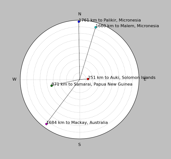
| ||||||||||||||||
Event and active stations
|
|||||||||||||||||
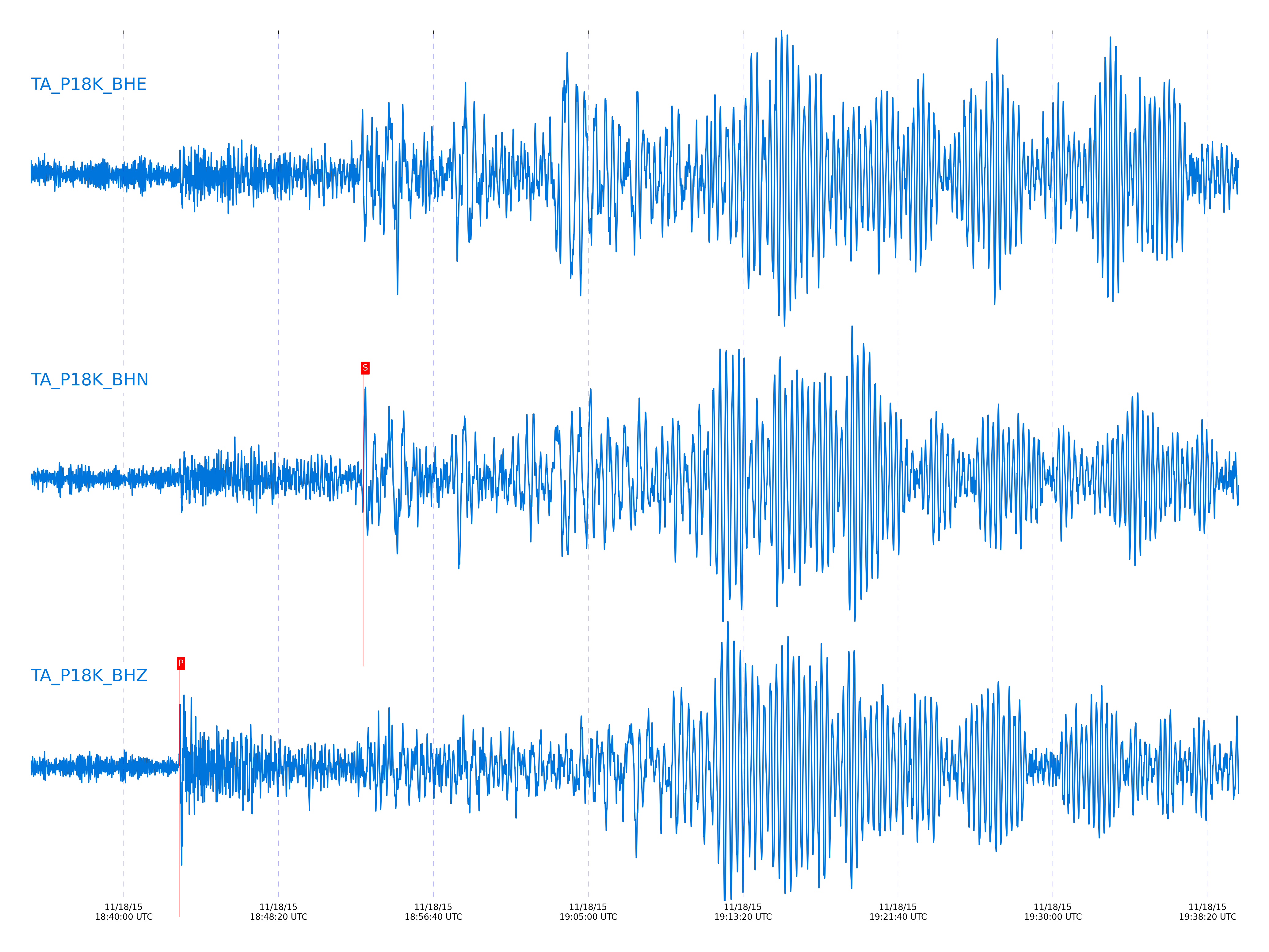
Seismic waveforms for closest station
Closest station with identified signal. Not filtered.
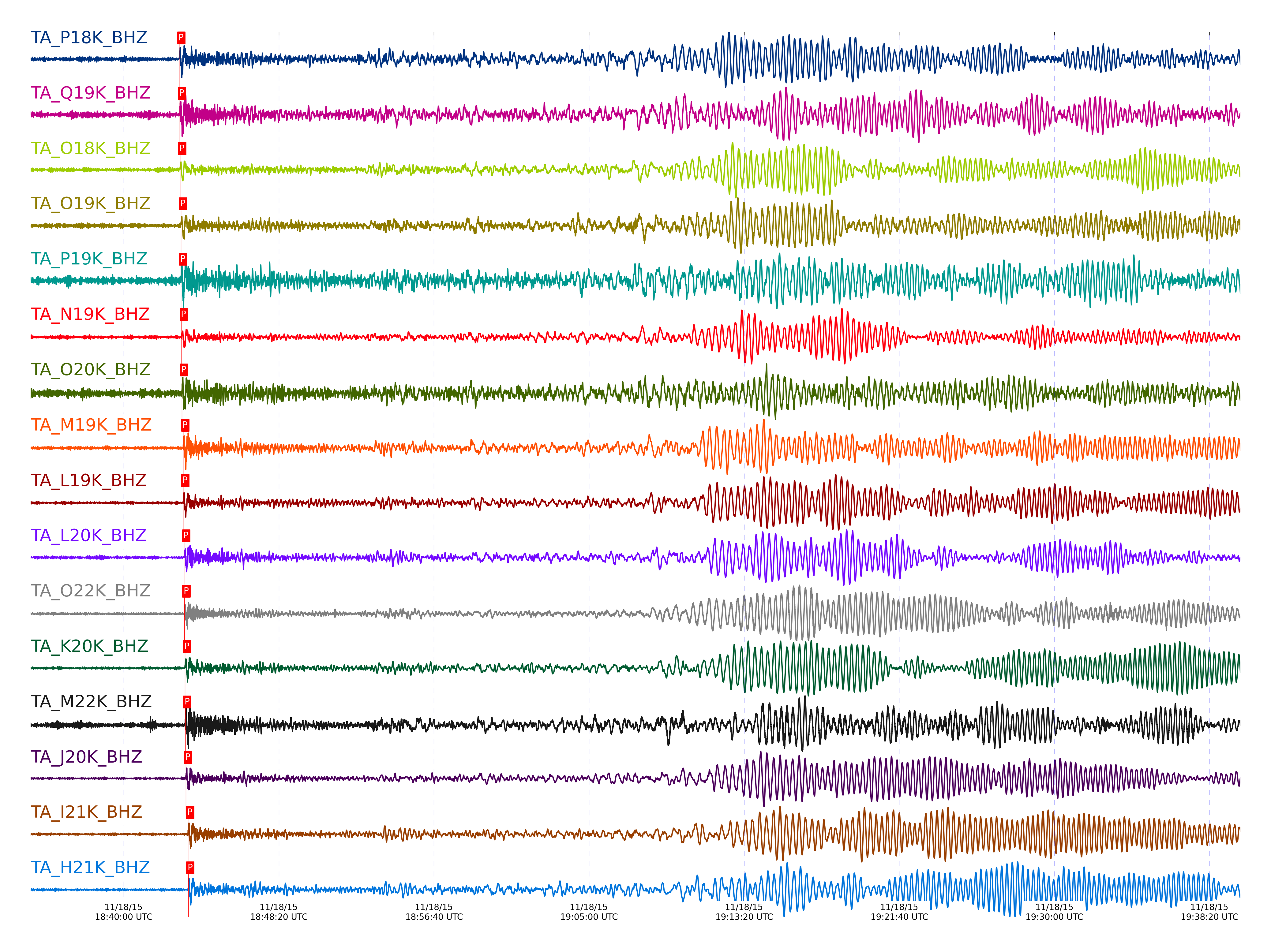
Seismic waveforms for vertical channels in network
Subset of several stations close to the event. Not filtered.
Signal description at some stations
| STA_CHAN | S-E Delta | S-E Azimuth | Phase | Time | Signal/Noise | Time Residual | V. Model | Auth | arid |
|---|---|---|---|---|---|---|---|---|---|
| P18K_BHZ | 77.639° | 227.04° | P | 2015-11-18 18:42:58.8156 UTC | 20.138 | -1.935 | iasp91 | dbp:mcwhite:153 | 16130650 |
| Q19K_BHZ | 77.93° | 228.59° | P | 2015-11-18 18:43:00.8657 UTC | 36.652 | -1.504 | iasp91 | dbp:mcwhite:153 | 16130652 |
| O18K_BHZ | 77.962° | 226.99° | P | 2015-11-18 18:43:01.5207 UTC | -1 | -1.028 | iasp91 | dbp:mcwhite:153 | 16130653 |
| O19K_BHZ | 78.52° | 227.76° | P | 2015-11-18 18:43:04.425 UTC | 12.529 | -1.208 | iasp91 | dbp:mcwhite:153 | 16130655 |
| P19K_BHZ | 78.566° | 228.86° | P | 2015-11-18 18:43:04.8578 UTC | 19.646 | -1.03 | iasp91 | dbp:mcwhite:153 | 16130657 |
| N19K_BHZ | 78.876° | 227.52° | P | 2015-11-18 18:43:06.5665 UTC | 25.126 | -1.029 | iasp91 | dbp:mcwhite:153 | 16130658 |
| O20K_BHZ | 79.078° | 229.36° | P | 2015-11-18 18:43:07.0734 UTC | 13.184 | -1.624 | iasp91 | dbp:mcwhite:153 | 16130659 |
| M19K_BHZ | 79.646° | 227.45° | P | 2015-11-18 18:43:11.8977 UTC | -1 | 0.102 | iasp91 | dbp:mcwhite:153 | 16130663 |
| L19K_BHZ | 79.676° | 226.98° | P | 2015-11-18 18:43:11.875 UTC | 90.515 | -0.081 | iasp91 | dbp:mcwhite:153 | 16130662 |
| L20K_BHZ | 80.21° | 227.86° | P | 2015-11-18 18:43:14.8263 UTC | -1 | -0.017 | iasp91 | dbp:mcwhite:153 | 16130667 |
| O22K_BHZ | 80.443° | 231.99° | P | 2015-11-18 18:43:15.425 UTC | 37.574 | -0.672 | iasp91 | dbp:mcwhite:153 | 16130669 |
| K20K_BHZ | 80.737° | 227.57° | P | 2015-11-18 18:43:17.5 UTC | 87.108 | -0.17 | iasp91 | dbp:mcwhite:153 | 16130674 |
| M22K_BHZ | 81.08° | 231.46° | P | 2015-11-18 18:43:17.8913 UTC | -1 | -1.611 | iasp91 | dbp:mcwhite:153 | 16130675 |
| J20K_BHZ | 81.266° | 227.4° | P | 2015-11-18 18:43:20.3 UTC | 136.4 | -0.186 | iasp91 | dbp:mcwhite:153 | 16130681 |
| I21K_BHZ | 82.624° | 229.34° | P | 2015-11-18 18:43:27.225 UTC | 121.65 | -0.395 | iasp91 | dbp:mcwhite:153 | 16130695 |
| H21K_BHZ | 82.679° | 228.52° | P | 2015-11-18 18:43:27.7195 UTC | -1 | -0.189 | iasp91 | dbp:mcwhite:153 | 16130697 |
| M24K_BHZ | 82.779° | 235.06° | P | 2015-11-18 18:43:28.4954 UTC | 92.472 | 0.068 | iasp91 | dbp:mcwhite:153 | 16130700 |
| N25K_BHZ | 83.113° | 236.55° | P | 2015-11-18 18:43:29.8849 UTC | 56.277 | -0.27 | iasp91 | dbp:mcwhite:153 | 16130704 |
| HARP_BHZ | 83.335° | 235.97° | P | 2015-11-18 18:43:30.7783 UTC | 34.083 | -0.522 | iasp91 | dbp:mcwhite:153 | 16130707 |
| I23K_BHZ | 83.454° | 231.81° | P | 2015-11-18 18:43:30.553 UTC | 78.844 | -1.357 | iasp91 | dbp:mcwhite:153 | 16130706 |
| TCOL_BHZ | 83.79° | 233.23° | P | 2015-11-18 18:43:32.2 UTC | 76.425 | -1.428 | iasp91 | dbp:mcwhite:153 | 16130711 |
| POKR_BHZ | 84.08° | 233.61° | P | 2015-11-18 18:43:33.4 UTC | 70.921 | -1.708 | iasp91 | dbp:mcwhite:153 | 16130714 |
| M26K_BHZ | 84.176° | 237.94° | P | 2015-11-18 18:43:35.3956 UTC | -1 | -0.198 | iasp91 | dbp:mcwhite:153 | 16130718 |
| H24K_BHZ | 84.362° | 233.14° | P | 2015-11-18 18:43:35.9305 UTC | -1 | -0.605 | iasp91 | dbp:mcwhite:153 | 16130719 |
| L26K_BHZ | 84.372° | 237.57° | P | 2015-11-18 18:43:36.55 UTC | 117.07 | -0.041 | iasp91 | dbp:mcwhite:153 | 16130721 |
| M27K_BHZ | 84.595° | 238.96° | P | 2015-11-18 18:43:38.1535 UTC | 141.96 | 0.44 | iasp91 | dbp:mcwhite:153 | 16130725 |
| L27K_BHZ | 84.978° | 238.95° | P | 2015-11-18 18:43:39.75 UTC | 103.54 | 0.112 | iasp91 | dbp:mcwhite:153 | 16130727 |
| J26L_BHZ | 85.087° | 237.25° | P | 2015-11-18 18:43:40. UTC | 90.881 | -0.186 | iasp91 | dbp:mcwhite:153 | 16130728 |
| TOLK_BHZ | 85.56° | 231.35° | P | 2015-11-18 18:43:42.375 UTC | 85.972 | -0.17 | iasp91 | dbp:mcwhite:153 | 16130733 |
| A21K_BHZ | 85.566° | 224.44° | P | 2015-11-18 18:43:41.577 UTC | -1 | -0.998 | iasp91 | dbp:mcwhite:153 | 16130731 |
| N31M_BHZ | 86.71° | 244.5° | P | 2015-11-18 18:43:48.75 UTC | 134.26 | 0.538 | iasp91 | dbp:mcwhite:153 | 16130743 |
| M30M_BHZ | 86.76° | 243.54° | P | 2015-11-18 18:43:48.5907 UTC | -1 | 0.134 | iasp91 | dbp:mcwhite:153 | 16130742 |
| J29M_BHZ | 87.052° | 242.16° | P | 2015-11-18 18:43:50.8 UTC | 72.654 | 0.923 | iasp91 | dbp:mcwhite:153 | 16130744 |
| L02E_BHZ | 87.207° | 255.34° | P | 2015-11-18 18:43:52.7328 UTC | 6.7024 | 2.107 | iasp91 | dbp:mcwhite:153 | 16130749 |
| K02D_BHZ | 87.298° | 255.27° | P | 2015-11-18 18:43:52.1343 UTC | 6.0917 | 1.066 | iasp91 | dbp:mcwhite:153 | 16130747 |
| O02D_BHZ | 87.31° | 255.97° | P | 2015-11-18 18:43:52.7611 UTC | 32.318 | 1.638 | iasp91 | dbp:mcwhite:153 | 16130750 |
| I29M_BHZ | 87.443° | 242.04° | P | 2015-11-18 18:43:51.4 UTC | 264.77 | -0.363 | iasp91 | dbp:mcwhite:153 | 16130745 |
| P33M_BHZ | 87.505° | 247.18° | P | 2015-11-18 18:43:52.0079 UTC | 22.038 | -0.053 | iasp91 | dbp:mcwhite:153 | 16130746 |
| M02C_BHZ | 87.557° | 255.88° | P | 2015-11-18 18:43:54. UTC | 33.834 | 1.689 | iasp91 | dbp:mcwhite:153 | 16130752 |
| N02D_BHZ | 87.564° | 255.99° | P | 2015-11-18 18:43:53.875 UTC | 28.804 | 1.531 | iasp91 | dbp:mcwhite:153 | 16130751 |
| M31M_BHZ | 87.606° | 245.71° | P | 2015-11-18 18:43:52.525 UTC | 89.593 | -0.018 | iasp91 | dbp:mcwhite:153 | 16130748 |
| I03D_BHZ | 87.775° | 255.45° | P | 2015-11-18 18:43:54.8397 UTC | -1 | 1.493 | iasp91 | dbp:mcwhite:153 | 16130753 |
| O03E_BHZ | 88.069° | 256.61° | P | 2015-11-18 18:43:56. UTC | 42.21 | 1.257 | iasp91 | dbp:mcwhite:153 | 16130756 |
| L04D_BHZ | 88.154° | 256.22° | P | 2015-11-18 18:43:56.2328 UTC | 12.056 | 1.09 | iasp91 | dbp:mcwhite:153 | 16130757 |
| G03D_BHZ | 88.214° | 255.46° | P | 2015-11-18 18:43:55.3361 UTC | -1 | -0.091 | iasp91 | dbp:mcwhite:153 | 16130755 |
| M04C_BHZ | 88.387° | 256.54° | P | 2015-11-18 18:43:57.7487 UTC | 19.326 | 1.503 | iasp91 | dbp:mcwhite:153 | 16130762 |
| H04D_BHZ | 88.405° | 255.85° | P | 2015-11-18 18:43:58.1415 UTC | -1 | 1.813 | iasp91 | dbp:mcwhite:153 | 16130766 |
| I04A_BHZ | 88.455° | 256.1° | P | 2015-11-18 18:43:58.6268 UTC | -1 | 2.061 | iasp91 | dbp:mcwhite:153 | 16130769 |
| EPYK_BHZ | 88.482° | 243.47° | P | 2015-11-18 18:43:56.4946 UTC | 194.06 | -0.197 | iasp91 | dbp:mcwhite:153 | 16130758 |
| J04D_BHZ | 88.536° | 256.32° | P | 2015-11-18 18:43:58.0027 UTC | 10.248 | 1.057 | iasp91 | dbp:mcwhite:153 | 16130764 |
| F04D_BHZ | 88.603° | 255.61° | P | 2015-11-18 18:43:56.639 UTC | -1 | -0.623 | iasp91 | dbp:mcwhite:153 | 16130759 |
| K04D_BHZ | 88.645° | 256.58° | P | 2015-11-18 18:43:58.5139 UTC | -1 | 1.055 | iasp91 | dbp:mcwhite:153 | 16130767 |
| D03D_BHZ | 88.913° | 255.53° | P | 2015-11-18 18:44:00.6701 UTC | -1 | 1.952 | iasp91 | dbp:mcwhite:153 | 16130774 |
| E04D_BHZ | 89.016° | 255.93° | P | 2015-11-18 18:43:59.7382 UTC | 5.4475 | 0.533 | iasp91 | dbp:mcwhite:153 | 16130770 |
| J05D_BHZ | 89.166° | 256.92° | P | 2015-11-18 18:44:01.575 UTC | 19.824 | 1.669 | iasp91 | dbp:mcwhite:153 | 16130779 |
| I05D_BHZ | 89.331° | 256.84° | P | 2015-11-18 18:44:01.393 UTC | 6.939 | 0.712 | iasp91 | dbp:mcwhite:153 | 16130777 |
| A04D_BHZ | 89.454° | 255.8° | P | 2015-11-18 18:44:01.978 UTC | 5.6552 | 0.723 | iasp91 | dbp:mcwhite:153 | 16130782 |
| G05D_BHZ | 89.553° | 256.84° | P | 2015-11-18 18:44:02.9434 UTC | -1 | 1.226 | iasp91 | dbp:mcwhite:153 | 16130786 |
| F05D_BHZ | 89.602° | 256.74° | P | 2015-11-18 18:44:02.8347 UTC | -1 | 0.886 | iasp91 | dbp:mcwhite:153 | 16130785 |
| B05D_BHZ | 89.736° | 256.26° | P | 2015-11-18 18:44:03.2961 UTC | 11.233 | 0.721 | iasp91 | dbp:mcwhite:153 | 16130787 |
| 109C_BHZ | 90.235° | 259.54° | P | 2015-11-18 18:44:06.9817 UTC | 8.7304 | 2.08 | iasp91 | dbp:mcwhite:153 | 16130797 |
| C06D_BHZ | 90.439° | 257.15° | P | 2015-11-18 18:44:07.2606 UTC | -1 | 1.412 | iasp91 | dbp:mcwhite:153 | 16130798 |
| R11A_BHZ | 92.398° | 260.54° | P | 2015-11-18 18:44:16.175 UTC | 145.47 | 1.26 | iasp91 | dbp:mcwhite:153 | 16130816 |
| 214A_BHZ | 93.66° | 261.79° | P | 2015-11-18 18:44:22.751 UTC | 13.152 | 2.038 | iasp91 | dbp:mcwhite:153 | 16130821 |
| A36M_BHZ | 94.298° | 254.3° | P | 2015-11-18 18:44:23.1253 UTC | -1 | -0.503 | iasp91 | dbp:mcwhite:153 | 16130822 |
| W18A_BHZ | 96.603° | 263.74° | P | 2015-11-18 18:44:36.297 UTC | -1 | 2.215 | iasp91 | dbp:mcwhite:153 | 16130829 |
| H17A_BHZ | 96.926° | 264.31° | P | 2015-11-18 18:44:38.4444 UTC | -1 | 2.911 | iasp91 | dbp:mcwhite:153 | 16130830 |
| O20A_BHZ | 98.261° | 265.29° | P | 2015-11-18 18:44:44.1767 UTC | 15.756 | 2.679 | iasp91 | dbp:mcwhite:153 | 16130835 |
| Y22D_BHZ | 98.808° | 265.17° | Pdiff | 2015-11-18 18:44:46.6478 UTC | -1 | 2.723 | iasp91 | dbp:mcwhite:153 | 16130836 |
| S22A_BHZ | 99.171° | 265.8° | Pdiff | 2015-11-18 18:44:49.2564 UTC | -1 | 3.719 | iasp91 | dbp:mcwhite:153 | 16130839 |
| K22A_BHZ | 99.72° | 266.81° | Pdiff | 2015-11-18 18:44:49.1844 UTC | -1 | 1.21 | iasp91 | dbp:mcwhite:153 | 16130838 |
| N23A_BHZ | 100.056° | 266.89° | Pdiff | 2015-11-18 18:44:51.3616 UTC | -1 | 1.898 | iasp91 | dbp:mcwhite:153 | 16130841 |
| Q24A_BHZ | 100.562° | 267.04° | Pdiff | 2015-11-18 18:44:55.3626 UTC | -1 | 3.651 | iasp91 | dbp:mcwhite:153 | 16130845 |
| T25A_BHZ | 101.051° | 267.14° | Pdiff | 2015-11-18 18:44:58.2071 UTC | -1 | 4.328 | iasp91 | dbp:mcwhite:153 | 16130848 |
| MSTX_BHZ | 102.232° | 267.43° | Pdiff | 2015-11-18 18:45:00.7117 UTC | -1 | 1.586 | iasp91 | dbp:mcwhite:153 | 16130849 |
| KSCO_BHZ | 102.523° | 268.62° | Pdiff | 2015-11-18 18:45:02.0154 UTC | -1 | 1.601 | iasp91 | dbp:mcwhite:153 | 16130850 |
| MDND_BHZ | 104.612° | 272.85° | Pdiff | 2015-11-18 18:45:11.6999 UTC | -1 | 2.012 | iasp91 | dbp:mcwhite:153 | 16130854 |
| ABTX_BHZ | 104.803° | 268.81° | Pdiff | 2015-11-18 18:45:11.7276 UTC | -1 | 1.193 | iasp91 | dbp:mcwhite:153 | 16130855 |
| 833A_BHZ | 104.89° | 267.79° | Pdiff | 2015-11-18 18:45:13.6533 UTC | -1 | 2.733 | iasp91 | dbp:mcwhite:153 | 16130857 |
| SUSD_BHZ | 105.217° | 272.42° | Pdiff | 2015-11-18 18:45:13.9678 UTC | -1 | 1.595 | iasp91 | dbp:mcwhite:153 | 16130858 |
| BGNE_BHZ | 105.927° | 272.13° | Pdiff | 2015-11-18 18:45:16.8587 UTC | -1 | 1.335 | iasp91 | dbp:mcwhite:153 | 16130860 |
| 435B_BHZ | 106.524° | 269.36° | Pdiff | 2015-11-18 18:45:20.6688 UTC | -1 | 2.493 | iasp91 | dbp:mcwhite:153 | 16130864 |
| WHTX_BHZ | 106.643° | 269.79° | Pdiff | 2015-11-18 18:45:18.1755 UTC | -1 | -0.529 | iasp91 | dbp:mcwhite:153 | 16130861 |
| TUL1_BHZ | 107.965° | 271.95° | Pdiff | 2015-11-18 18:45:25.3852 UTC | -1 | 0.814 | iasp91 | dbp:mcwhite:153 | 16130866 |
| SPMN_BHZ | 109.499° | 277.11° | Pdiff | 2015-11-18 18:45:32.1258 UTC | -1 | 0.746 | iasp91 | dbp:mcwhite:153 | 16130867 |
| W39A_BHZ | 109.627° | 272.9° | Pdiff | 2015-11-18 18:45:35.1088 UTC | -1 | 3.159 | iasp91 | dbp:mcwhite:153 | 16130871 |
| U40A_BHZ | 110.312° | 273.88° | Pdiff | 2015-11-18 18:45:36.5948 UTC | -1 | 1.603 | iasp91 | dbp:mcwhite:153 | 16130873 |
| U40A_BHZ | 110.312° | 273.88° | PKiKP | 2015-11-18 18:49:35.7752 UTC | -1 | -0.441 | iasp91 | dbp:mcwhite:153 | 16130895 |
| X40A_BHZ | 110.443° | 273.2° | Pdiff | 2015-11-18 18:45:36.8399 UTC | -1 | 1.267 | iasp91 | dbp:mcwhite:153 | 16130874 |
| Z41A_BHZ | 110.533° | 272.75° | Pdiff | 2015-11-18 18:45:37.9154 UTC | -1 | 1.944 | iasp91 | dbp:mcwhite:153 | 16130875 |
| W41B_BHZ | 110.882° | 273.8° | Pdiff | 2015-11-18 18:45:39.9394 UTC | -1 | 2.42 | iasp91 | dbp:mcwhite:153 | 16130876 |
| W41B_BHZ | 110.882° | 273.8° | PKiKP | 2015-11-18 18:49:37.0643 UTC | -1 | -0.228 | iasp91 | dbp:mcwhite:153 | 16130896 |
| L44A_BHZ | 113.439° | 279.51° | Pdiff | 2015-11-18 18:45:55.7086 UTC | -1 | 6.839 | iasp91 | dbp:mcwhite:153 | 16130881 |
| SFIN_BHZ | 114.337° | 279.31° | PKiKP | 2015-11-18 18:49:44.5678 UTC | -1 | 0.685 | iasp91 | dbp:mcwhite:153 | 16130898 |
| SFIN_BHZ | 114.337° | 279.31° | Pdiff | 2015-11-18 18:45:56.6193 UTC | -1 | 3.761 | iasp91 | dbp:mcwhite:153 | 16130883 |
| P49A_BHZ | 116.28° | 280.59° | PKPdf | 2015-11-18 18:49:46.9809 UTC | -1 | -0.621 | iasp91 | dbp:mcwhite:153 | 16130900 |
| P52A_BHZ | 118.212° | 282.49° | Pdiff | 2015-11-18 18:46:12.8059 UTC | 6.2094 | 2.75 | iasp91 | dbp:mcwhite:153 | 16130889 |
| P52A_BHZ | 118.212° | 282.49° | PKPdf | 2015-11-18 18:49:50.3445 UTC | -1 | -0.953 | iasp91 | dbp:mcwhite:153 | 16130901 |
| O53A_BHZ | 118.76° | 283.5° | Pdiff | 2015-11-18 18:46:17.0456 UTC | 7.6451 | 4.555 | iasp91 | dbp:mcwhite:153 | 16130892 |
| O53A_BHZ | 118.76° | 283.5° | PKPdf | 2015-11-18 18:49:51.825 UTC | -1 | -0.523 | iasp91 | dbp:mcwhite:153 | 16130904 |
| M53A_BHZ | 118.867° | 284.54° | Pdiff | 2015-11-18 18:46:15.293 UTC | 6.6022 | 2.329 | iasp91 | dbp:mcwhite:153 | 16130891 |
| M53A_BHZ | 118.867° | 284.54° | PKPdf | 2015-11-18 18:49:52.0652 UTC | -1 | -0.486 | iasp91 | dbp:mcwhite:153 | 16130905 |
| N54A_BHZ | 119.487° | 284.8° | PKPdf | 2015-11-18 18:49:53.5356 UTC | -1 | -0.202 | iasp91 | dbp:mcwhite:153 | 16130906 |
| M54A_BHZ | 119.58° | 285.35° | PKPdf | 2015-11-18 18:49:53.5728 UTC | -1 | -0.344 | iasp91 | dbp:mcwhite:153 | 16130907 |
| KMSC_BHZ | 119.735° | 280.61° | PKiKP | 2015-11-18 18:49:54.5232 UTC | -1 | 0.173 | iasp91 | dbp:mcwhite:153 | 16130908 |
| O56A_BHZ | 120.711° | 285.51° | PKPdf | 2015-11-18 18:49:56.0344 UTC | -1 | -0.043 | iasp91 | dbp:mcwhite:153 | 16130910 |
| N59A_BHZ | 122.556° | 288.09° | PKPdf | 2015-11-18 18:49:59.3935 UTC | 16.728 | -0.207 | iasp91 | dbp:mcwhite:153 | 16130915 |
| P60A_BHZ | 122.992° | 287.52° | PKPdf | 2015-11-18 18:50:00.3738 UTC | -1 | -0.057 | iasp91 | dbp:mcwhite:153 | 16130916 |
| L61B_BHZ | 124.207° | 291.61° | PKPdf | 2015-11-18 18:50:02.925 UTC | 18.966 | 0.179 | iasp91 | dbp:mcwhite:153 | 16130919 |
External resources
Current seismic activity measured by the seismic network
Click the link below to observe an interactive map of earthquakes recorded by the station deployment: