last update to page: March 04 2019 21:02:56 (UTC).
Magnitude 5.3 Earthquake: Colorado
SummaryThe red marker denotes the earthquake epicenter. On Mon Mar 4th 2019 17:22:51 (UTC) the seismic network recorded an earthquake (preliminary 5.3 ml) located in Colorado. Seismic region Eastern North America. The epicentral distance (i.e. distance separating the location to the epicenter) to the closest station S22A in the network is 192.0 km. If you felt the quake, the USGS would like to know. Please add your comments to the USGS page "Did you feel it?". |
Details
Proximity to Population Centers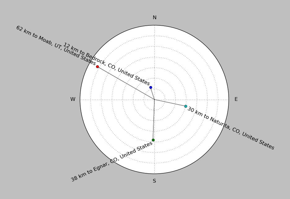
| ||||||||||||||||
Event and active stations
|
|||||||||||||||||
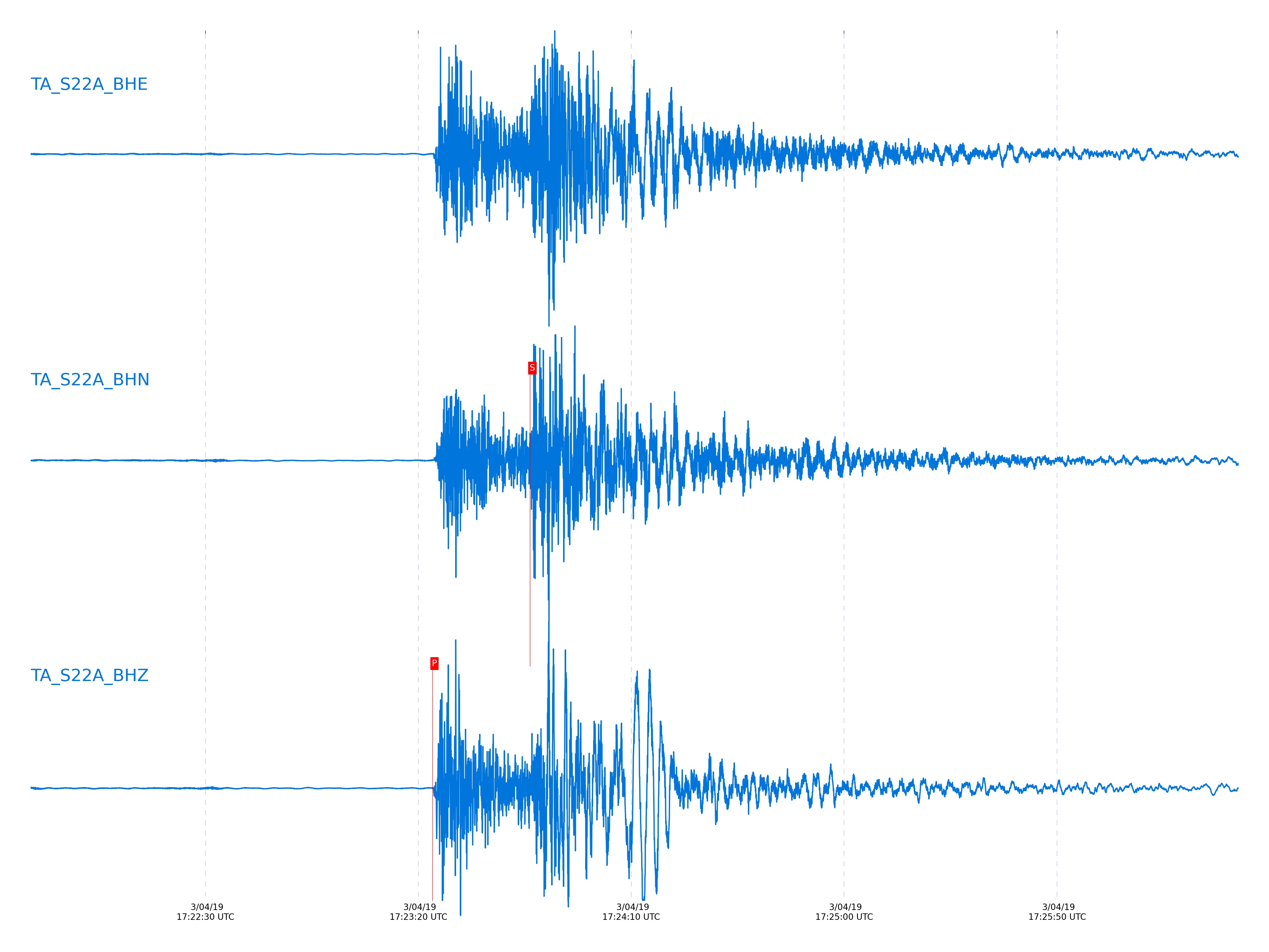
Seismic waveforms for closest station
Closest station with identified signal. Not filtered.
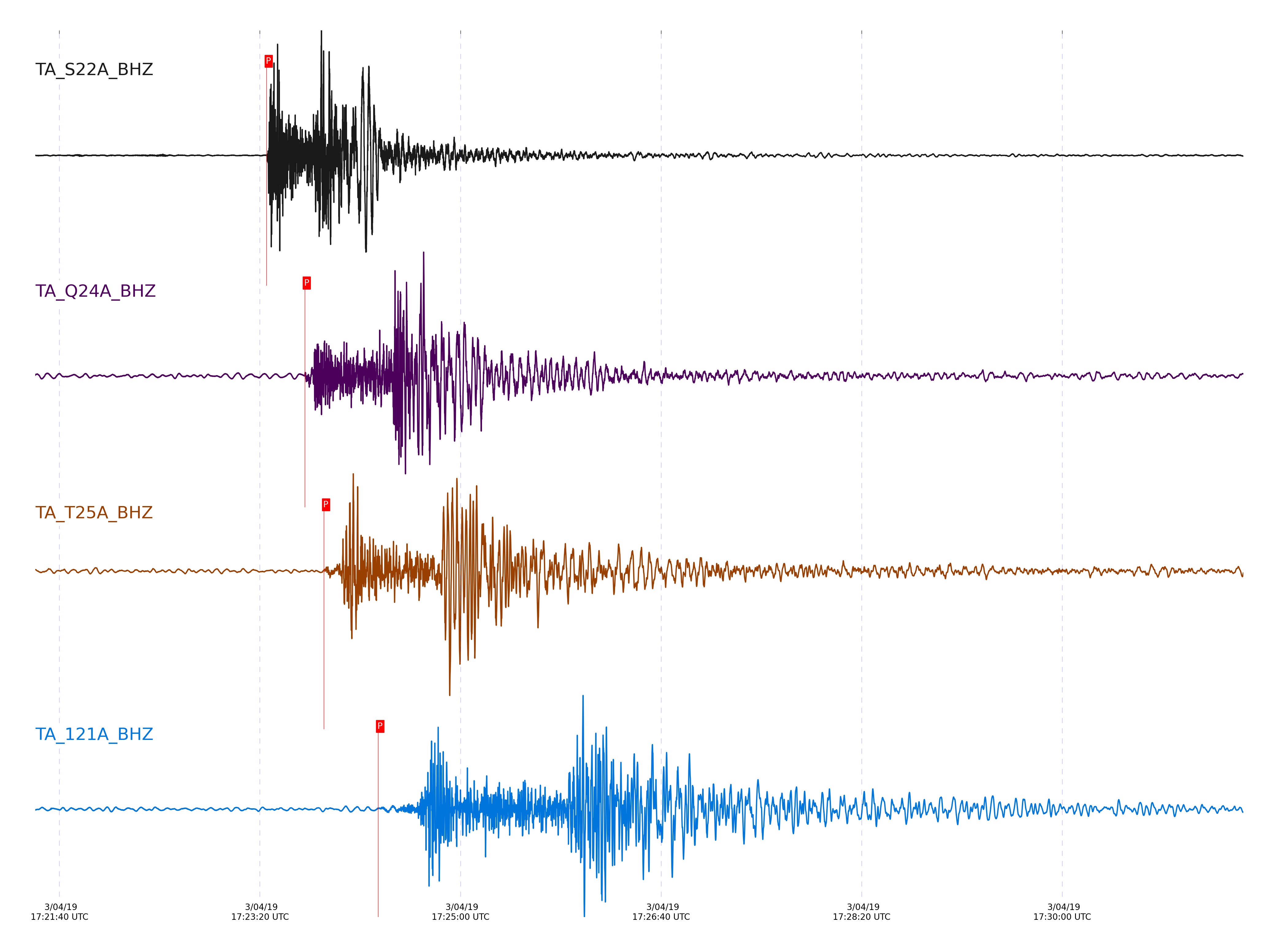
Seismic waveforms for vertical channels in network
Subset of several stations close to the event. Not filtered.
Signal description at some stations
| STA_CHAN | S-E Delta | S-E Azimuth | Phase | Time | Signal/Noise | Time Residual | V. Model | Auth | arid |
|---|---|---|---|---|---|---|---|---|---|
| S22A_BHZ | 1.725° | 288.68° | pPn | 2019-03-04 17:23:23.3506 UTC | 3857.3 | 0.278 | iasp91 | dbp:tcox:19063 | 5775918 |
| Q24A_BHZ | 3.017° | 258.08° | pPn | 2019-03-04 17:23:42.3452 UTC | 237.36 | 1.499 | iasp91 | dbp:tcox:19063 | 5775919 |
| T25A_BHZ | 3.738° | 289.15° | pPn | 2019-03-04 17:23:51.9097 UTC | 21.136 | 1.15 | iasp91 | dbp:tcox:19063 | 5775920 |
| 121A_BHZ | 5.821° | 351.25° | Pn | 2019-03-04 17:24:18.9237 UTC | 10.458 | -0.275 | iasp91 | dbp:tcox:19063 | 5775922 |
| T35M_BHZ | 23.382° | 133.97° | pP | 2019-03-04 17:28:03.1726 UTC | -1 | 0.666 | iasp91 | dbp:tcox:19063 | 5776072 |
| R33M_BHZ | 25.363° | 136.51° | pP | 2019-03-04 17:28:21.0619 UTC | -1 | 0.483 | iasp91 | dbp:tcox:19063 | 5776075 |
| Q32M_BHZ | 25.525° | 133.76° | P | 2019-03-04 17:28:23.1601 UTC | -1 | -1.053 | iasp91 | dbp:tcox:19063 | 5776076 |
| P33M_BHZ | 26.597° | 134.72° | pP | 2019-03-04 17:28:31.9173 UTC | -1 | 0.157 | iasp91 | dbp:tcox:19063 | 5776077 |
| I30M_BHZ | 31.308° | 135.83° | pP | 2019-03-04 17:29:14.2571 UTC | 7.7607 | 0.585 | iasp91 | dbp:tcox:19063 | 5775934 |
| I28M_BHZ | 32.541° | 131.22° | pP | 2019-03-04 17:29:24.4037 UTC | 8.4155 | -0.078 | iasp91 | dbp:tcox:19063 | 5775938 |
| G26K_BHZ | 34.694° | 127.95° | pP | 2019-03-04 17:29:43.3944 UTC | 5.4053 | 0.2 | iasp91 | dbp:tcox:19063 | 5775940 |
| E25K_BHZ | 35.947° | 127.03° | pP | 2019-03-04 17:29:55.0754 UTC | 8.4812 | 1.106 | iasp91 | dbp:tcox:19063 | 5775942 |
| C27K_BHZ | 36.374° | 130.94° | pP | 2019-03-04 17:29:58.2001 UTC | 7.1503 | 0.583 | iasp91 | dbp:tcox:19063 | 5775954 |
| D25K_BHZ | 36.906° | 127.33° | pP | 2019-03-04 17:30:03.2257 UTC | 14.845 | 1.071 | iasp91 | dbp:tcox:19063 | 5775955 |
| H20K_BHZ | 37.813° | 112.99° | pP | 2019-03-04 17:30:10.8734 UTC | 8.0559 | 1.035 | iasp91 | dbp:tcox:19063 | 5775946 |
| E22K_BHZ | 37.899° | 119.55° | pP | 2019-03-04 17:30:11.4592 UTC | 8.9321 | 0.896 | iasp91 | dbp:tcox:19063 | 5775948 |
| D20K_BHZ | 39.733° | 114.72° | pP | 2019-03-04 17:30:26.9047 UTC | 6.3507 | 0.964 | iasp91 | dbp:tcox:19063 | 5775950 |
| A22K_BHZ | 40.265° | 119° | pP | 2019-03-04 17:30:31.1428 UTC | 9.1835 | 0.79 | iasp91 | dbp:tcox:19063 | 5775952 |
External resources
Current seismic activity measured by the seismic network
Click the link below to observe an interactive map of earthquakes recorded by the station deployment: